-
Welcome to this forum . We are a worldwide group with a common interest in Birmingham and its history. While here, please follow a few simple rules. We ask that you respect other members, thank those who have helped you and please keep your contributions on-topic with the thread.
We do hope you enjoy your visit. BHF Admin Team
You are using an out of date browser. It may not display this or other websites correctly.
You should upgrade or use an alternative browser.
You should upgrade or use an alternative browser.
A month or so back there was something locally about "naturalising" the river in Calthorpe park so I looked up some of the story about how it got to be culverted and moved. The story goes that there was heavy flooding in various parts of Birmingham near the Rea Valley in the 1890s so the City Council decided to "improve" the river to drain the floodwater. They straightened bits and cut the culverted section to make it take more water and run faster. There were more floods in the 1930s so they deepened the culvert again. Nowadays it seems none of the river is entirely natural. The river that fed the Speedwell mills would have been much closer to the surface and a hundred yards or so east of where the river is now.
Dave M
Pheasey Born Bumper
There's a DVD on Birmingham's River Rea. I believe it runs into The Tame which runs into The Trent which runs into The Humber which finally runs into The North Sea. Is this correct?
The River Rea runs into the River Tame near behind Costco Heatlands Spine Rd, the river Tame runs into the river Trent at the far end of the National Memorial Arboretum at Alrewas.
jennyann
Gone but not forgotten. R.I.P.
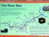
Hi: Here's an outline of where the River Rea flows https://www.riverreatrail.org.uk/index.php?option=com_content&task=view&id=60&Itemid=124 followed by the fact that the River Severn which it flows into subsequently flows into the Bristol Channel https://en.wikipedia.org/wiki/River_Severn
Had to check this up as I remember some details of this from school...a long time ago!
Had to check this up as I remember some details of this from school...a long time ago!
jennyann
Gone but not forgotten. R.I.P.
Quite right Rupert. I got that wrong...the river Rea actually merges with the River Tame and then into the Trent then on into the Humber and finally into the North Sea. No wonder I didn't get a good mark on the "Rivers" test at school! https://en.wikipedia.org/wiki/River_Rea So yes, Steve TQ you're correct the river Rea does eventually end up in the North Sea.
Wexfordlass
New Member
We use to play down the river rea and there was a bridge that we called the dark 1/2 hour how we didn't fall in i don't know we played anywhere as kids in the 1960s.
Hi: Here's an outline of where the River Rea flows https://www.riverreatrail.org.uk/index.php?option=com_content&task=view&id=60&Itemid=124 followed by the fact that the River Severn which it flows into subsequently flows into the Bristol Channel https://en.wikipedia.org/wiki/River_Severn
Had to check this up as I remember some details of this from school...a long time ago!
Thanks, this answered my question.
The River Tame, now carrying the water from the Rea, joins the River Trent, further on, and in its turn the Trent flows into the Humber and out into the North Sea. You can find the River Trent and the North Sea on a map of the British Isles.
Have a great Sunday! Steve C
In the 60's/70's I lived off Popes Lane near The Rea and the Reservoirs along Wychall Lane. The woods of mainly Willow trees and the very large tree on the banks of The Rea on the path to the rezza was our playground. We would make dens and rafts out of oil drums and pallets acquired from Triplex dump alongside the railway. Triplex used to dump everything on that tip (no way it would be allowed now). It kept us everything we need to build some amazing dens in the woods. They would throw out the imperfect windscreens, which would have great fun in smashing.
One scam which I'm claiming to have started was the selling of Bullrushes door to door as flower arrangements. We would wade waist height to cut them down with my Mom's carving knife. We made a fortune in the first summer, then other gangs moved in.
We used to spend most of the summer at Northfield Baths if wet or Rowheath Lido when sunny (mom worked at Cadburys so got the free pass for 4 people). We would spend hours I these places then take hours to walk home.
At 57 these happy times are so far away. We didn't have much money, but I have lots of lovely memories. Money can't buy that!
flossiefoster
master brummie
Hi Steve!
I think you had the best time in the 60/70s before everything changed beyond recognition. From what you say everyone would have a fit these days to read how you spent the time out of school. But that's what children did then and it was safe to be just children. Though I don't know about you having your Mom's carving knife to cut the bulrushes but I do admire your enterprise. I think you should be proud you had a "childhood" as that is something children today do not have. Fantastic memories - enjoy! Best wishes Denise
I think you had the best time in the 60/70s before everything changed beyond recognition. From what you say everyone would have a fit these days to read how you spent the time out of school. But that's what children did then and it was safe to be just children. Though I don't know about you having your Mom's carving knife to cut the bulrushes but I do admire your enterprise. I think you should be proud you had a "childhood" as that is something children today do not have. Fantastic memories - enjoy! Best wishes Denise
GeoffMiller
Brummie babby
GeoffMiller
Brummie babby
A friend of mine once had an old print of the river at Digbeth where people, in what looked like Georgian clothing, picnicked and punted on the river.
Not like that now.
My father also told me that when he was a kid they could catch trout in the river. That was before the Austin etc started to pump all their sewage into it and killed off all the life.
Not like that now.
My father also told me that when he was a kid they could catch trout in the river. That was before the Austin etc started to pump all their sewage into it and killed off all the life.
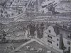
I could be wrong but I don't think that the Rea has ever carried much water , except in flood conditions. However there was a millpond that was engineered for the Heath Mill/Coopers Mill in Floodgate Street. The weir made there formed a mill pond with the mill and head race draining off at Fazeley Street...just below the River Street junction. The weir backed up the Rea to above Digbeth bridge and would have formed a kind of reservoir there for rowing on. The owner of the mill had to sign a covenant not to back the river up too much because traffic would be disrupted at the Derritend bridge. The Westly Aspect shows all of this and the horsemen are standing on River Street and the angler is fishing in the mill pond.
The mill pond was eventually filled in and Gulverton Tin Works was built on top of the filling. The delapidated tin works is still there I think and the Rea runs along side of it in a deep manufactured channel...still open under Fazley St. and then under the canal to emerge at Montague Street at the point of the recently posted sketch.The run of the Rea now in that place is not a natural one. The natural path would have been further north from the flood gate and would have passed by Warwick Wharf I thnk...the wharf and canal not being there at the time.
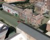
Two views included; one of Westleys aspect and the other of the view today. Same building I am pretty sure but much modified. Fazeley Street and River Street.
In the Westley picture you can see the original run of the Rea just above the fishermen. At that point it would have just been carrying water that ran over the flood gate...the rest of the water going over the tandem mill wheels which can be seen. This is all eerily recognisable today...even the Montague Street sketch and one wonders if a dig on the side of the bridge in Fazely St. would not discover a mill stone. Being heavy, they would probably have just been buried when any demolition took place
The mill pond was eventually filled in and Gulverton Tin Works was built on top of the filling. The delapidated tin works is still there I think and the Rea runs along side of it in a deep manufactured channel...still open under Fazley St. and then under the canal to emerge at Montague Street at the point of the recently posted sketch.The run of the Rea now in that place is not a natural one. The natural path would have been further north from the flood gate and would have passed by Warwick Wharf I thnk...the wharf and canal not being there at the time.
Two views included; one of Westleys aspect and the other of the view today. Same building I am pretty sure but much modified. Fazeley Street and River Street.
In the Westley picture you can see the original run of the Rea just above the fishermen. At that point it would have just been carrying water that ran over the flood gate...the rest of the water going over the tandem mill wheels which can be seen. This is all eerily recognisable today...even the Montague Street sketch and one wonders if a dig on the side of the bridge in Fazely St. would not discover a mill stone. Being heavy, they would probably have just been buried when any demolition took place
Attachments
N
Neville Philpott
Guest
Many years ago i was mooching around Rea Street and happened to look through a works gate opening and one of the lunch time workers took me through
to see the river as it flowed through their back yard. I can't recall the name of the company but i do remember the river not being much of a flow....
to see the river as it flowed through their back yard. I can't recall the name of the company but i do remember the river not being much of a flow....
The river as we know it was rebuilt as a flood channel over a century ago and deepened to cope with worse flooding during the 1930s. On bad days it fills up the channel at places and overflows in others (notably just before Belgrave Road and previously in Cannon Hill Park). It can run 10-15 feet deep.I could be wrong but I don't think that the Rea has ever carried much water , except in flood conditions.
Old time building stayed away from the flood plains and you can see evidence of this in old pictures on this forum, here and Hockley Brook. If building on flood plains is to take place then deepening measures have to be taken. Even then the measures are not always adequate but occurencies are very few.
Old time building stayed away from the flood plains and you can see evidence of this in old pictures on this forum, here and Hockley Brook. If building on flood plains is to take place then deepening measures have to be taken. Even then the measures are not always adequate but occurencies are very few.
I don't know how long ago "Old time" is supposed to be but the deepening and diversion of the Rea came about after a couple of floods in the mid-late 1800s. The Rea was converted to take all the excess surface water in the area - or that was the intent. Work started in the 1890s and was completed within 10-20 years (I don't remember exactly). The work straightened and culverted most of the river between Bourn Brook and the Tame. New floods in the 30s meant that sections of the river had to be deepened to cope with the additional water. I got the original data from council reports in the central library and made some notes that I don't have to hand (I may have lost them) so you'll have to excuse the bits I'm vague about.
It would appear that the housing affected by the flooding must have been built in the early to middle 1800s in the first wave of mass house building in the area. Presumably nobody thought that much about flood plains at the time. I have vague memories of reading somewhere that Calthorpe Estates weren't particularly worried about the quality of housing that they put up or other developers put up on the land the Estate controlled/sold. Maybe that had something to do with it.
Phil
Gone, but not forgotten.
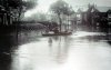
Yes they couldn't have been thinking much of flood plains when they built these houses in Selly Park and Stirchley. As for depth of the Rea it could be quite deep in parts. I remember where we used to swim in the rea at the back of Cannon Hill Park as kids and we used to dive in to it off high clay banks.
Attachments

It's like anything. Records are made to be broken and climates change. Of course they had to consider the flood table and must have taken measures. They did not work all of the time. Most of the rivers and brooks are culverted now and mostly there is not much flow. At least I never noticed much.
Hi phil;
yes you are quite correct in what you are saying especialy in selly park ; and the surrounding avenues along with st johns
i know the st johns very wellindeed and also the first three or four avenues tat run along it at the back of the park ; and most of the inhabbitants
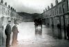
on the picture of the st johns where the boat is the third bay window was used to be the head accountants house for the water board ;
he lived there along with a brother and his wife and his own son ; I used to go to his house quite regular his wife used to make cakes for sale big wedding cakes and a varity of occasions for about25 pounds i think it was she made my late father inlaw one way ;l way back in time ;
they was in the late stages of life when they all died there is a few celebs living down there or should i say there was a pop singer a well known councillor and a a couple of well known actors still live in st johns but i am not allowed tosay as you know these people still alive and living there
one councillor lives more or less oppersite this house and the actor l[ a lady still lives there she as been there all her life she his elderly now and disababled
when the BBC was at pebble mill all the surrounding streets of them avenueswas really thriving and buzzing with well known people and producers and stars
its been inthe last eight years that almost all the top names have gone from those streets even a well known one from the east enders now an mp and some of our news readers have final gone ;thanks for the cracking picture i am sure there will be other memers with there bits of memory of the old place sellypark as
changed dramiticly but the flooding still goes on down there especialy st johns avenue and the first two avenues still come flooding ;
have a good day best wishes astonian;;
yes you are quite correct in what you are saying especialy in selly park ; and the surrounding avenues along with st johns
i know the st johns very wellindeed and also the first three or four avenues tat run along it at the back of the park ; and most of the inhabbitants
on the picture of the st johns where the boat is the third bay window was used to be the head accountants house for the water board ;
he lived there along with a brother and his wife and his own son ; I used to go to his house quite regular his wife used to make cakes for sale big wedding cakes and a varity of occasions for about25 pounds i think it was she made my late father inlaw one way ;l way back in time ;
they was in the late stages of life when they all died there is a few celebs living down there or should i say there was a pop singer a well known councillor and a a couple of well known actors still live in st johns but i am not allowed tosay as you know these people still alive and living there
one councillor lives more or less oppersite this house and the actor l[ a lady still lives there she as been there all her life she his elderly now and disababled
when the BBC was at pebble mill all the surrounding streets of them avenueswas really thriving and buzzing with well known people and producers and stars
its been inthe last eight years that almost all the top names have gone from those streets even a well known one from the east enders now an mp and some of our news readers have final gone ;thanks for the cracking picture i am sure there will be other memers with there bits of memory of the old place sellypark as
changed dramiticly but the flooding still goes on down there especialy st johns avenue and the first two avenues still come flooding ;
have a good day best wishes astonian;;
WE lived in Kitchener Rd then Cartland Rd in the 90's. We would quite often cycle or walk along the path into Cannon Hill Park alongside the Rea. It was cleared out in the 80's and quite often carried flood water in heavy rainfall times. Anyone who has seen Stirchley in a storm will know how the drain covers explode into fountains. Cartland Rd used to flood regularly. I have a Photo of our house under 3 feet of water.
All Central B'hams water eventually ends up via Minworth Sewage works thence to Whitacre Heath where a settlement lake is used to clear it before it flows into the Tame. One occasional task I had was to retrieve bodies from the Boom at Coton Rd, where they ended up after going in somewhere in the city.
All Central B'hams water eventually ends up via Minworth Sewage works thence to Whitacre Heath where a settlement lake is used to clear it before it flows into the Tame. One occasional task I had was to retrieve bodies from the Boom at Coton Rd, where they ended up after going in somewhere in the city.
River Rae at Fazely Street. The photo is the other side of the aquaduct shown on sketch middle left. Both photo and sketch posted previously by others. Just below the yellow cross is the Gun Barrel Proof House and above is St Phillips. Green lines are Birmingham and Warwick canals. Added Picture.
Attachments
During the programme they mentioned the Banana unloading area, if possible can someone pinpoint the area as I would like to visit there Thanks Dave
In my student days I used to leave our house in Castle Bromwich every weekday about four in the morning and ride into town to meet my uncle who was a fishmonger and greengrocer in Cotteridge. It helped pay my way.
He would make his way around the Fish and Veg markets ahead of me placing orders for the shop and I would follow his route around the stalls looking for his tickets at each wholesaler and then load the produce they had put out onto a barrow. (I think I had to hire the barrow)
You learned to be smart as sometimes what they offerred for collection wasn't exactly what he had ordered as his standards were quite high for a suburban shop.
Once loaded I would find his old Morris van and transfer the barrowload before heading off for another round of collections. Though most were in the main markets some items were in the cold stores beneath Moor Street Station where they had been unloaded from wagons which were transferred by lifts to the two sub levels of the Goods Station. They were in the area between Park Street, Well Lane and Allison Street beneath the viaduct.
One of my ports of call was the Banana shed beneath the Goods Station where the green bananas having been rail freighted up from Southampton Docks had been placed in cellars to ripen either using xylene or ripe tomatoes to hasten the process.
These two pics were taken quite recently (and slightly illegally) of what where part of the underground stores most which have been recycled as the new Bull Ring car park.
https://images.birminghamhistory.co.uk/coppermine/displayimage.php?album=lastup&cat=0&pid=11113#top_display_media
https://images.birminghamhistory.co.uk/coppermine/displayimage.php?album=lastup&cat=0&pid=11114#top_display_media
Nearby was another port of call which was Barracloughs Potato store which was generally pitch black to lessen the chance of the vegetable sprouting and this trip was often the last requiring an empty barrow. Meeting big black rats was quite normal though a bit unsettling when they would sometimes jump out of the sack I had on my back.
By sevenish I had done my shift and we settled down to a bloke's breakfast before I rode over to Gosta Green for a nap in the Common Room before college.
I could be wrong but I don't think that the Rea has ever carried much water , except in flood conditions. However there was a millpond that was engineered for the Heath Mill/Coopers Mill in Floodgate Street. The weir made there formed a mill pond with the mill and head race draining off at Fazeley Street...just below the River Street junction. The weir backed up the Rea to above Digbeth bridge and would have formed a kind of reservoir there for rowing on. The owner of the mill had to sign a covenant not to back the river up too much because traffic would be disrupted at the Derritend bridge. The Westly Aspect shows all of this and the horsemen are standing on River Street and the angler is fishing in the mill pond.
The mill pond was eventually filled in and Gulverton Tin Works was built on top of the filling. The delapidated tin works is still there I think and the Rea runs along side of it in a deep manufactured channel...still open under Fazley St. and then under the canal to emerge at Montague Street at the point of the recently posted sketch.The run of the Rea now in that place is not a natural one. The natural path would have been further north from the flood gate and would have passed by Warwick Wharf I thnk...the wharf and canal not being there at the time.
Two views included; one of Westleys aspect and the other of the view today. Same building I am pretty sure but much modified. Fazeley Street and River Street.
In the Westley picture you can see the original run of the Rea just above the fishermen. At that point it would have just been carrying water that ran over the flood gate...the rest of the water going over the tandem mill wheels which can be seen. This is all eerily recognisable today...even the Montague Street sketch and one wonders if a dig on the side of the bridge in Fazely St. would not discover a mill stone. Being heavy, they would probably have just been buried when any demolition took place
I have been digitising some of Brunel's Contract drawings for the Birmingham and Oxford Junction railway held at The National Archive in Kew as part of research into the Duddeston Viaduct.
The original drawings are in a sorry state sadly having been poorly stored for several years before being handed over to the TNA. Many are on vellum and linen paper and have become very brittle.
One of the first to be completed covers the section around Heath Mill Lane/Great Barr Street/Liverpool Street northwards toward the Rea crossing and the link will display with north to the left.
https://images.birminghamhistory.co.uk/coppermine/displayimage.php?album=lastup&cat=10449&pid=11128#top_display_media
The second file is a scrap from the Society for the Diffusion of Knowledge map for the same area and tilted in roughly the same viewing plane

https://images.birminghamhistory.co...=lastup&cat=10449&pid=11127#top_display_media
Brunel's survey would have taken place around 1845-6 when the Act of Parliament was presented and therefore compares in time to the SDUK map which was produced around the same time and shows the course of the "Little Rea" leading away from the Mill Pool north eastwards.
Brunel's survey also shows a similar line feature appearing north of the Warwick Canal and heading in the same alignment as the present Montague Street.
The line itself snakes across the area, tiptoing past established factories with many of the abutments still in situ marching across the "small gardens" that bordered the rivers.
At this time the part of Montague Street beginning at Great Barr Street is only titled as "Proposed New Street" but nevertheless determined the many complex skewed arches that were constructed in the now lost section toward Curzon Street.
So if Rupert's buried millstones are to be found my bones tells me they will be around or beneath the Council Car Park but they could be quite deep down.
The main section of the River Rea is 6.5 feet lower than the base of the canal so if the original alignment of the Little Rea was culverted it will be beneath the base of the canal.
Last edited by a moderator:
In post #70 I proposed that the later day aerial shot of the building on Fazeley St. was in fact the same building as the one on the Westly Prospect and thought that it might have started off as Coopers residence. Now, to the north of this building, lower down on the proposed Fazeley St. the tandem mill whees can be seen just by the dam with the horse and rider on it. Sure the building is modified but there are several cues to it being the same and also historical writing about it's history. I don't know what the Little Rae refers to but propose that it actually refers to the 'original' Rae natural route which was dammed probably at Floodgate St. and have already proposed that it ran somewhere under the later Warwick Wharf. The dam would have forced the Rae water up to higher ground to the south and formed a long mill pool with a head above the Rae. In other words pretty normal leat pond and tailrace routine. What was actually formed was a very long millpond and backed up the Rae all the way to Derrittend Bridge which originally would have been a wide causeway with stepping stones...according to reports of damaging traffic to the Bull Ring market. The Little Rae/original course would not have been at any elevation at all to form a raised mill pond at Warwick Wharf just looking at it.
I can't see your pictures to comment on them. Maybe if you post in the regular forum format.
I think that the Little Rae became just a millpool run off device for maintaining the level in the large millpool lake. It all seems pretty obvious but then again how often do the Time Team dig in the wrong place. Show us your maps
B
BernardR
Guest
Rupert the links 'Speedwing' has put up link to 'Coppermine'. Fascinating information and images thanks Rupert and Speedwing.
Edit - I hope 'Speedwing' does not mind but I have edited the post so that the images now show without the need to click through to 'Coppermine'?
Edit - I hope 'Speedwing' does not mind but I have edited the post so that the images now show without the need to click through to 'Coppermine'?
Last edited by a moderator: