sylviasayers
master brummie
Can anyone find Potter Street around 1900. I am pretty sure it is not Potter's Hill, or Potter's Lane. May be around Newtown Row/Summer Lane area.
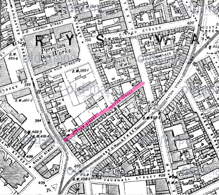
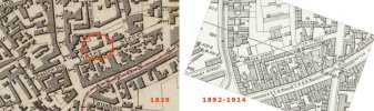
Thanks Mike, I notice your map shows what looks like a little alleyway on the right ... just the first letters of a name showing in the photo.The dates given for the maps were publication dates. The survey dates were always earlier. The map was probably around 1900. There is a later map c 1915 (probably surveyed c1913), as below, on which I have marked what must be the Weights and measures office from looking at the directories
Thanks Mike, I notice your map shows what looks like a little alleyway on the right ... just the first letters of a name showing in the photo.


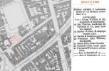
another great photo...not easy to findA later view of Potter Street and the Weights & Measures Offices .... dated as 1932.
View attachment 207511
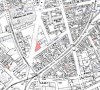
What a WONDERFUL photograph this is - there is so much going on in it, and the fact it probably sourced from a glass plate negative means you can zoom in to really examine the detailHere is a view of Potter Street in 1905. I would suggest that the buildings on th eleft are the ones in red on the 1886 map below
View attachment 207435View attachment 207437


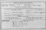
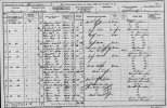
Yes Lynlooking at the map there does not seem to be too many houses in potter st so just out of interest i wonder if we could find potter st on the 1901 census....i am certain the living conditions would have been very bad as was most of that area
lyn
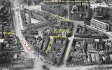
thanks john...some of these aerial views are very goodAn aerial view from 1937 showing the last remnants of Potter Street.
 1875.jpg")
if the location is correct i wonder what side of the street this was taken as looking at other photos of it i cant see any houses with attics unless they were added to the houses shown on post 15This photo shows a row of old houses in Potter Street. I believe it's one of the series of photos taken by James Burgoyne showing sites that would be affected by the construction of Corporation Street. That development started in the 1870's, but the section that crossed Potter Street was not completed until the early 1900's.
View attachment 207581
 (James Burgoyne) c1900.jpg")
Difficult to say. But if they were being demolished to build that section of Corporation Street, then they would have been near to Lancaster Street.if the location is correct i wonder what side of the street this was taken as looking at other photos of it i cant see any houses with attics unless they were added to the houses shown on post 15
lyn
Great image and so atmospheric.This photo shows a row of old houses in Potter Street. I believe it's one of the series of photos taken by James Burgoyne showing sites that would be affected by the construction of Corporation Street. That development started in the 1870's, but the section that crossed Potter Street was not completed until the early 1900's.
View attachment 207581