-
Welcome to this forum . We are a worldwide group with a common interest in Birmingham and its history. While here, please follow a few simple rules. We ask that you respect other members, thank those who have helped you and please keep your contributions on-topic with the thread.
We do hope you enjoy your visit. BHF Admin Team
You are using an out of date browser. It may not display this or other websites correctly.
You should upgrade or use an alternative browser.
You should upgrade or use an alternative browser.
Old street pics..
- Thread starter Astoness
- Start date

farmerdave
master brummie
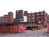
This is called "Central Place after Improvement" in 1937 showing the Fire Station and a tram and trolley bus on their travels. Not sure which way the tram is going but hope it is going away from us otherwise the car is in danger of getting wrecked! I walked down Corporation Street many times towards the College then University at Gosta Green but never knew that the area in front of the Fire Station was called Central Place. Dave.
.jpg")
Radiorails
master brummie
The pic, in post 4690, is now in the DR Harvey collection I believe.
It shows tramcar 668, built in 1925, going from the city on the 79 Pype Hayes route. The trolley bus is No.12, OJ 1012 which entered service in 1932 but had a short operational life as it was withdrawn in 1940 and stored during WW2 only to be sold for breaking up in 1946. The picture shows it on trolleybus route 7 to Nechells which operated until the end of September 1940. The TB 7 had replaced tram route 7 in 1922.
Bus route 43 took over in October 1940.
The problem for the Nechells trolleybus route was that the system for gaining the depot was one pole and a return skate on the tram rails. This caused arcing which was considered most undesirable during the hours of darkness as so much of interest, to the Luftwaffe, lay in that side of the city. The reason for this method of current collection, it appears, was due to the 8 Alum Rock and 10 Washwood Heath tramcars being fitted with a bow collector instead of the more common single pole.
I am grateful for verifying my information from the book by David Harvey entitled Birmingham Trolleybuses 1922 - 1951.
farmerdave
master brummie
Thanks for that Radiorails. It provides a lot of interesting information for the photograph. My source for the photograph in # 4690 was the "City of Birmingham Handbook; a publication of the City of Birmingham Information Bureau" published in January 1938. The name of the photographer is unfortunately not given. DaveThe pic, in post 4690, is now in the DR Harvey collection I believe.
It shows tramcar 668, built in 1925, going from the city on the 79 Pype Hayes route. The trolley bus is No.12, OJ 1012 which entered service in 1932 but had a short operational life as it was withdrawn in 1940 and stored during WW2 only to be sold for breaking up in 1946. The picture shows it on trolleybus route 7 to Nechells which operated until the end of September 1940. The TB 7 had replaced tram route 7 in 1922.
Bus route 43 took over in October 1940.

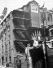
Interesting view of what to me is the old Suffolk Street (incorrectly labelled here as Digbeth) in its last days as a simple two-way road. View looking towards Holloway Circus with Allport Street on the right and on the left the Technical College.
The occasion seems to be the transport of a preserved locomotive en route to a museum? Dated 20 May 1966
https://www.rail-online.co.uk/p645258869/h5522efbc#h5522efbc
The occasion seems to be the transport of a preserved locomotive en route to a museum? Dated 20 May 1966
https://www.rail-online.co.uk/p645258869/h5522efbc#h5522efbc
norfolk brummie
gone but not forgotten
Richie; The occasion seems to be the transport of a preserved locomotive en route to a museum? Dated 20 May 1966 [URL said:https://www.rail-online.co.uk/p645258869/h5522efbc#h5522efbc[/URL]
City of Birmingham on route to the museum
Eddie
DavidGrain
master brummie
This would be the loco City Of Birmingham which was taken to the old Science Museum in Newhall Street but now at Millenium Point. The confusion of the street name is because the loco did come up Digbeth on its way if you look at the other photos. Of particular note is that it is on the wrong side of the road passing the Bordesley Flyover. "Running wrong road" to use a railway term.
OK this isnt technically a street pic, but it is a pic of streets . To help visualise where streets have changed path or disappeared completely I did a transition between this 1890 map and the current googlemap.

Noticing little things like the green lawn next to the modern chapel on Carrs Lane is the site of the original one
Noticing little things like the green lawn next to the modern chapel on Carrs Lane is the site of the original one
")
Excellent transformation, Wobag, but dare I say it? Can I have the old one back please?
Maurice
ditto mauice...everytime
lyn
Dennis Williams
Gone but not forgotten
Whoa a bit Wobag! Could you post both please...separately....me eyes and brain is too old to see the transitions clearly..? Be very grateful...must say I think this is a very novel and original way of looking at history for me anyway...LOVE it....!
Last edited:
Brilliant Wobag! For those that want to study it a bit more, maybe a longer time lapse between the images? And if you plan to do more of them, maybe a new thread? Think they're absolutely fascinating. To make this comparison manually would take much more individual time and effort, so you've saved us a lot of time. Many thanks. Viv.

That's a great one too Wobag. Shows clearly how Moor Street was diverted from its original course to make way for them Bull Ring. Was that in the 1960s or for the more recent redevelopment? I only use iPad now, and if I hold my fingers on the map it keeps it from changing until I'm ready to compare it with the other map. Then I take my fingers off and ..... Magic! Viv.
After reviewing a 1990s road map, the changes to Moor Street were part down to the 60s version and part the recent version. In the 60s, the modern double sided Moor street was cut off at the point you see, and flowed into the new St Martins Circus that ran around the part of the bullring that had the gardens in it. There also appears to have been a small section of the original Moor Street left.
The current path where Moor street bends immediately around Moor Street Station, down the side of the Selfridges building and joins Park St appears to be part of the newest development. Ill try and find a better map to show that.
The current path where Moor street bends immediately around Moor Street Station, down the side of the Selfridges building and joins Park St appears to be part of the newest development. Ill try and find a better map to show that.

Admin, if you feel this shouldnt be on here, i understand if you delete. Carol
https://www.youtube.com/watch?v=ncnO5AOC1IQ
https://www.youtube.com/watch?v=ncnO5AOC1IQ
I Am Nico
master brummie
Admin, if you feel this shouldnt be on here, i understand if you delete. Carol
https://www.youtube.com/watch?v=ncnO5AOC1IQ
That made me want to look at it Carolina it's brilliant, here's mud in your eye!
Two postcards of Aston Cross. Difficult to imagine this today as the junction has completely changed. But where was the photographer standing? Rocky Lane? Aston Road North? Lichfield Road? Or has the clock been moved? Today, there's still a pub standing from the period (but now residential). But maybe the pub isn't in shot unless it's one of the buildings to the right in the postcards. Viv.
View attachment 101666View attachment 101667
I am sure I remember Aston Cross from my childhood but seem also to remember the smell of the brown sauce factory. Wasn't that nearby??
Phil
Gone, but not forgotten.
Katrina
HP sauce was just to the left of those two photos just off Park Lane between Aston Cross and the A38 Expressway. Which Cross Keys are you asking about.
HP sauce was just to the left of those two photos just off Park Lane between Aston Cross and the A38 Expressway. Which Cross Keys are you asking about.
Attachments
Many thanks for your prompt reply Phil. There was certainly a distinctive smell from the factory, does anyone else remember it?? The Cross Keys was a pub that my dad ran but that might have been nearer to the Bull Ring. But he also at one point ran a pub at Cross Keys it might have been The Eagle???