-
Welcome to this forum . We are a worldwide group with a common interest in Birmingham and its history. While here, please follow a few simple rules. We ask that you respect other members, thank those who have helped you and please keep your contributions on-topic with the thread.
We do hope you enjoy your visit. BHF Admin Team
You are using an out of date browser. It may not display this or other websites correctly.
You should upgrade or use an alternative browser.
You should upgrade or use an alternative browser.
Old street pics..
- Thread starter Astoness
- Start date
paul stacey
master brummie
The one thing that hasn't changed , is three workmen leaning on, 1, shovel. Paul
Very funny Paul! Val de Travers is an area in Switzerland famous for its asphalt mines. Maybe the name came from that? There's a sign for Tarslag in the middle of the road too. Was that part of Tarmac? Viv.
Lyn
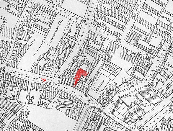
Have marked where photo was taken from with red arrow. Bonsers, an iron merchants, is at no 85, and is the narrow building with the tall roof half way between the digbeth Institute and Oxford St, and is marked in red on the map. Now I think only the frontage remains
Have marked where photo was taken from with red arrow. Bonsers, an iron merchants, is at no 85, and is the narrow building with the tall roof half way between the digbeth Institute and Oxford St, and is marked in red on the map. Now I think only the frontage remains
Morning Lyn. Oxford Street to the left. Hard to imagine the road with a central reservation which was being shown in the photo. Viv.

thanks viv...not the same place is it...
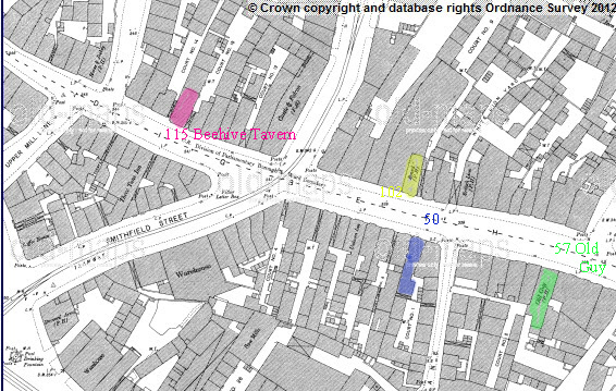
thanks for the map mike..just wondering if the old guy pub at no 57 is showing on it...this is where my grandad was living at the time of his marriage in 1929.. cant be sure now but i think some time back we said that after the old guy was demolished the police station was built on the ground..
lyn
thanks for the map mike..just wondering if the old guy pub at no 57 is showing on it...this is where my grandad was living at the time of his marriage in 1929.. cant be sure now but i think some time back we said that after the old guy was demolished the police station was built on the ground..
lyn
Dennis Williams
Gone but not forgotten
A reprise of some of that area for interest and maybe clarification....?


Dennis Williams
Gone but not forgotten
No Lyn, the Old Guy was the other side of the road. It is the PH just below the red arrow on the map
Never heard of it. Sounds cool though...got a piccy Lyn? Anyone?
Dennis Williams
Gone but not forgotten
Wow...even better...this is what Mckenna has to say....
CENTRAL BIRMINGHAM PUBS
The Old Guy Inn was situated on the site of the present Midland Red Coach Station.
Its original name was the Old Guy of Warwick, taking its name from a semi-mythical character, Guy, Earl of Warwick, who went around doing deeds of valour, and slaying giant cattle.
Christopher Fuller was licensee in 1767, according to the town's first trade directory. James Lees had taken over by 1776. During the 1850s the house changed its name to the Albion, after having a brick front added.
This was under licensee, Benjamin Jenkins. By I863, however, it had reverted to its original name under J. Cleton. By the I870s the house was given a complete overhaul.
Landlord Henry Griffiths called in architect Henry Holmes in February 1877 to design a new pub, with large picture windows.
At the turn of the century the house was noted for its entertainment in the form of freak shows, featuring Siamese twins, the fat lady and her sister the bearded lady, and any number of dwarfs.
It must have been rather akin to the present Broad Street on a Saturday night. The Old Guy's license was withdrawn, and the pub closed in I933, Albert Rose being its last licensee.
Also gone beneath the coach station was the Hand & Glove of 1767 to I770, under licensee Joseph Latham, and the 1860s Wine & Liquor Vaults, at 71 -72 High Street, run by Charles Swingler.
thanks dennis...i knew a little bit of info from mike albert rose was the landlord in 1929 when my grandad was living there as a lodger i suspect..my grandmother was at no 51 digbeth which was a fried fish place or chippy as we would call it now lol..the owners of the chippy were family friends and our dad well remembered as a nipper walking from hockley and taking a few of his mates to the chippy for free chips...i also knew about the old guy being noted for its freak shows..now why did i think it used to be on the other side of the road where the police station is...must have been a memory lapse lol would love to find a photo of this pub...
lyn
lyn
Last edited:
No Lyn, the Old Guy was the other side of the road. It is the PH just below the red arrow on the map
mike is it the pub opposite the institute ? im sure there was a pub on or near the site of the police station..i would have to dig out my old notes but it could well of been a pub that the downes side of my family ran...
lyn
Dennis Williams
Gone but not forgotten
Fascinating Mike and Lyn....heres a couple you've probably seen before...The Rose Tavern was where the Police Station is, corner of Allison Street, then there used to be an old pub on the opposite corner to that - The Horse and Jockey....so many pubs down Digbeth/Deritend High Street....some of the oldest marked here...on the 1751 Map...The White Hart and the Castle and Falcon...


Matthewammba
New Member
Hi all,
Great thread, some smashing photos. I wonder if anybody can help? I'm working on a digital project which traces the history of the Jewellery Quarter and some of the wider Hockley area through the use of trails, which can be followed using mobile devices. This is a not-for-profit project which will enable users to access the content for free.
One of the features on a trail is the Hockley Abbey. I'm trying to locate a picture of the abbey to use on the trail, but am struggling at the moment. Can anybody help provide an image which is either out of copyright or can be provided in exchange for a credit on the site.
Many thanks in advance.
Matthew
DavidGrain
master brummie
Hi all,
Great thread, some smashing photos. I wonder if anybody can help? I'm working on a digital project which traces the history of the Jewellery Quarter and some of the wider Hockley area through the use of trails, which can be followed using mobile devices. This is a not-for-profit project which will enable users to access the content for free.
One of the features on a trail is the Hockley Abbey. I'm trying to locate a picture of the abbey to use on the trail, but am struggling at the moment. Can anybody help provide an image which is either out of copyright or can be provided in exchange for a credit on the site.
Many thanks in advance.
Matthew
Matthew. Welcome to the Forum. If you are looking for a particular subject you will need to use the Search facility at the top right of the screen. I suggest you post you request on the Hockley Abbey thread https://birminghamhistory.co.uk/forum/showthread.php?t=2962&highlight=hockley+abbey
There were pictures of Hockley Abbey on that thread but some time ago this Forum got hacked and we lost the picture but your request is more likely to be answered on that thread
Phil
Gone, but not forgotten.
Matthew
Take a look here you will see the reasons why it was built and also a photo that you might get permission to use.
https://billdargue.jimdo.com/placenames-gazetteer-a-to-y/places-h/hockley/
Take a look here you will see the reasons why it was built and also a photo that you might get permission to use.
https://billdargue.jimdo.com/placenames-gazetteer-a-to-y/places-h/hockley/
Why are there two sets of weighing scales on the porch of the hotel? An observation, I think there maybe two auto cycles leaning against the porch above the word 'hotel'.
Appropriate as this was an Auto Cycle Union hotel in 1909.
Viv.
Maybe the two sets of scales were one for those going "in" to enjoy the fayre and the the "out" to indicate how swelling the fayre had made the indulger? Alternatively, one set of scales was the the gents and the other for ladies? (with the ladies' scales 'adjusted' in order not to reveal an indiscreet figure?)
Dancing queen
proper brummie kid
Hi I wonder if anyone knows anything about John Roberts in this lovely photograph
i had a grandfather named John Roberts he was born in Stratford upon Avon mothers maiden name was Eva canning.
probably not the one but I have to ask you .thanks..
i had a grandfather named John Roberts he was born in Stratford upon Avon mothers maiden name was Eva canning.
probably not the one but I have to ask you .thanks..
Dennis Williams
Gone but not forgotten
Another nice one I've not seen before...and one I think has been on recently...the junction of Paradise Street with Easy Row....turn on the Century perhaps, from the fashions...? and that little shop to the right of the Pharmacy in the first pic looks fascinating from whatever is above the door??


Last edited:
You don't often see detailed posters like that on older photos (re the first photo: The Birmingham New Building Co Ltd) explaining the plans for the new development. The plan seem to be for new shops (including a new pharmacy) and offices to be built on the site between the Woodman and the Garden Restaurant. Dennis I think the thingy above the shop doorway might be another one of those 'by appointment' shields. Birmingham seems to have had many at one time. I presume the building next door to that is the lovely old Woodman. But can t see any trace of the Garden Restaurant. Very nice photo. Viv.

Dennis Williams
Gone but not forgotten
Loved this old pic of the Navigation Inn in Wharf Road, Kings Norton from 134 years ago (1880)! Just been saved from demolition I gather....https://www.birminghammail.co.uk/ne...birmingham-pub-the-navigation-in-kings-189635
