-
Welcome to this forum . We are a worldwide group with a common interest in Birmingham and its history. While here, please follow a few simple rules. We ask that you respect other members, thank those who have helped you and please keep your contributions on-topic with the thread.
We do hope you enjoy your visit. BHF Admin Team
You are using an out of date browser. It may not display this or other websites correctly.
You should upgrade or use an alternative browser.
You should upgrade or use an alternative browser.
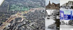
OLD BIRMINGHAM PHOTOS FROM STEVEBHx
- Thread starter SteveBhx
- Start date
devonjim
master brummie
Is this the building to the left of the bank?Sorry my wording the building to the left of the bank
.png")
Picture from Facebook "Old Pictures of Brum"
SteveBhx
master brummie
Yes I believe it isIs this the building to the left of the bank?View attachment 158725
Picture from Facebook "Old Pictures of Brum"


SteveBhx
master brummie
Another wall this one is 380 Stratford road in 1974, the main chimney seem to be an afterthought, and interesting that the decorative wall only goes half the way up. Building on the left looks quite decorative, and the old style road sign peeping out on the right. Not forgetting the Midland Bank which was swallowed up long ago ( HSBC?)


SteveBhx
master brummie
Finally 14 Warwick Road in 1974, interesting rear wall of the terrace, on the left, Henwick Villas - love these names, with a tailors and a printers - a proper one no doubt none of this computer nonsense !! Lovely ornamental windows, one painted one original , pity the harp advert spoils the building.

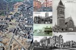
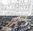
interesting shot steve....wonder if our members can identify any of the buildings left standing...i am lost at the minInteresting shot showing the march of the expressway from the north heading towards Birmingham, Aston Hall grounds at the top , and already rows of terraces have disappeared and gaps in roads have started with whole blocks empty .
View attachment 158734
lyn
aston lad
master brummie
Brilliant photo of my Aston, thanks for posting it. Just knowing where to start, top right square you can see Ansells on Aston Cross, to the left of it you can just make out the HP Sauce factory the one on Tower Road with the warehouse on the corner of Upper Thomas Street, which is just in front of the Upper Thomas Street schools, left middle of the photo where the green patch is , is The Retreat, the row of houses to the left is Clarendon Street where I was born and bred, my home can be seen but its hard to make out which one it is, at the top of the photo there are two roads which look quite long, the one on the left is Upper Sutton Street and the one on the right is Park Road.In the middle of the photo is a large building which looks like its on Aston Brook Street, sorry I cannot recall the name, but just above it you can see a flat piece of land, that was the old bomb peck which ran from Wilkinson Street down hill to Phillips Street now its the location of Aston Manor Secondary School, if you travel to the right you can just make out St Mary's Church and school, I think you can see where the Norton motorbikes where built in Bracebridge Road the building is right in the middle of the photo on the left, I am not sure about anymore buildings or roads apart from the road which runs through the centre of the photo which is Aston Road North, until Ansells then it becomes Litchfield Road...the date would have to be 1969 or very early 1970, we moved out in October 1969, and our house was pulled down not long after...interesting shot steve....wonder if our members can identify any of the buildings left standing...i am lost at the min
lyn
Susan shaw
master brummie
Hi Aston lad, Yes, what a brilliant photo. Unfortunately, I am useless with Ariel views and really struggle to spot places. I will go back and study it later. Aston will always be close to my heart, working there until 1970 and following the local football team! Would the building in Aston Brook Street be Benton & Stone, where I worked, which also backed on to Bracebridge Street? Very happy memories, though slowly fading. Kind regards, SueBrilliant photo of my Aston, thanks for posting it. Just knowing where to start, top right square you can see Ansells on Aston Cross, to the left of it you can just make out the HP Sauce factory the one on Tower Road with the warehouse on the corner of Upper Thomas Street, which is just in front of the Upper Thomas Street schools, left middle of the photo where the green patch is , is The Retreat, the row of houses to the left is Clarendon Street where I was born and bred, my home can be seen but its hard to make out which one it is, at the top of the photo there are two roads which look quite long, the one on the left is Upper Sutton Street and the one on the right is Park Road.In the middle of the photo is a large building which looks like its on Aston Brook Street, sorry I cannot recall the name, but just above it you can see a flat piece of land, that was the old bomb peck which ran from Wilkinson Street down hill to Phillips Street now its the location of Aston Manor Secondary School, if you travel to the right you can just make out St Mary's Church and school, I think you can see where the Norton motorbikes where built in Bracebridge Road the building is right in the middle of the photo on the left, I am not sure about anymore buildings or roads apart from the road which runs through the centre of the photo which is Aston Road North, until Ansells then it becomes Litchfield Road...the date would have to be 1969 or very early 1970, we moved out in October 1969, and our house was pulled down not long after...
thanks for the guided tour john...got my bearing now..my fault for not spotting the hp factoryBrilliant photo of my Aston, thanks for posting it. Just knowing where to start, top right square you can see Ansells on Aston Cross, to the left of it you can just make out the HP Sauce factory the one on Tower Road with the warehouse on the corner of Upper Thomas Street, which is just in front of the Upper Thomas Street schools, left middle of the photo where the green patch is , is The Retreat, the row of houses to the left is Clarendon Street where I was born and bred, my home can be seen but its hard to make out which one it is, at the top of the photo there are two roads which look quite long, the one on the left is Upper Sutton Street and the one on the right is Park Road.In the middle of the photo is a large building which looks like its on Aston Brook Street, sorry I cannot recall the name, but just above it you can see a flat piece of land, that was the old bomb peck which ran from Wilkinson Street down hill to Phillips Street now its the location of Aston Manor Secondary School, if you travel to the right you can just make out St Mary's Church and school, I think you can see where the Norton motorbikes where built in Bracebridge Road the building is right in the middle of the photo on the left, I am not sure about anymore buildings or roads apart from the road which runs through the centre of the photo which is Aston Road North, until Ansells then it becomes Litchfield Road...the date would have to be 1969 or very early 1970, we moved out in October 1969, and our house was pulled down not long after...
lyn
brummy-lad
master brummie
Steve, what an incredible image, thank-you so much for posting this, it's the only image I've seen to date that portrays an overall view of the devastation at this time. I could spend hours picking out areas from my childhood and have added a few street names and images to help in the orientation of the map.Interesting shot showing the march of the expressway from the north heading towards Birmingham, Aston Hall grounds at the top , and already rows of terraces have disappeared and gaps in roads have started with whole blocks empty .
View attachment 158734
The text on the images is probably illegible, better copies of the images can be found on:
www.leroux.co.uk/aston
Attachments
devonjim
master brummie
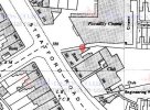
Clearly the carpark of the Piccadilly cinema in Sparkhill.Another wall this one is 380 Stratford road in 1974, the main chimney seem to be an afterthought, and interesting that the decorative wall only goes half the way up. Building on the left looks quite decorative, and the old style road sign peeping out on the right. Not forgetting the Midland Bank which was swallowed up long ago ( HSBC?)
View attachment 158733
pjmburns
master brummie
The building on the right was the Piccadilly Cinema - for once I knew where this was and was fairly certain it was a cinema but I had to look it up to get the name. Sadly no longer there. 1960s map. Tried to find a photo and ythis is from the Birmingham Mail websiteAnother wall this one is 380 Stratford road in 1974, the main chimney seem to be an afterthought, and interesting that the decorative wall only goes half the way up. Building on the left looks quite decorative, and the old style road sign peeping out on the right. Not forgetting the Midland Bank which was swallowed up long ago ( HSBC?)
View attachment 158733
Attachments
devonjim
master brummie
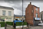
Blink and it's gone! Still there on Google Map as is the Smart Car.The building on the right was the Piccadilly Cinema - for once I knew where this was and was fairly certain it was a cinema but I had to look it up to get the name. Sadly no longer there. 1960s map. Tried to find a photo and ythis is from the Birmingham Mail website
.png")
SteveBhx
master brummie
Thanks, I have few pictures like that heading towards the city which I will post soonSteve, what an incredible image, thank-you so much for posting this, it's the only image I've seen to date that portrays an overall view of the devastation at this time. I could spend hours picking out areas from my childhood and have added a few street names and images to help in the orientation of the map.
The text on the images is probably illegible, better copies of the images can be found on:
www.leroux.co.uk/aston
pjmburns
master brummie
Apologies - you are correct - I was a little too far down the road where the building marked as a club was. It is indeed there - or was a few months ago.Blink and it's gone! Still there on Google Map as is the Smart Car.View attachment 158748
Thanks
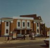
That view of the Piccadilly Cinema was exactly as I remembered it. Went to see many films there at the time and was the place that the whole of Golden Hillock Secondary Boys school was marched down to to watch a selection of short films/cartoons as a Christmas treat before we broke up for the Christmas holidays. DaveThe building on the right was the Piccadilly Cinema - for once I knew where this was and was fairly certain it was a cinema but I had to look it up to get the name. Sadly no longer there. 1960s map. Tried to find a photo and ythis is from the Birmingham Mail website


brummy-lad
master brummie
Another amazing image Steve, thank-you. When I created the interactive Aston map I could only identify the location for Image 3 (Clifton Road) by the construction of the expressway in the background and now with your map I can see exactly the view and looking closely at the aerial view you can actually see the tree shown on image 3.As promised her is another picture from the building of the expressway, this shows the full extent of Aston Halls grounds, Villa Park is rather small compared to today and the first piers of the elevated section are appearing
View attachment 158778
Also I like the view of Tower Road, we have so few images of that, in fact I have never seen images of the buildings nestled between the HP factory and UTS school which looked quite impressive.
Attachments
brummy-lad
master brummie
Yes Lyn, I love the britainfromabove images but to have these later images in colour and focussed on an area not covered by that website is brilliant. Fingers crossed that Steve may have one showing Parliament Street. These aerial views are invaluable.john i love trying to find my way around the overhead photos..
lyn
brummy-lad
master brummie
We have so few images of courts like that, it's great that you have this. Difficult to imagine the amount of noise and dust living next door to the construction site, must have been unbearable at times.My nan lived at 6 back 69 Clifton Road which I think on the photo on #2122 was the first house on the left of the block of back houses (north side) to the left of the mound of sand.
Attachments
SteveBhx
master brummie
As I do not know these areas it surprises me the reaction they get. I have plenty of aerial views but unfortunately they are often of the city centre I will post some with houses on when I am able and see what the reaction is. Thanks everyone for the appreciate comments and the additional comments it adds addition level of detail.Yes Lyn, I love the britainfromabove images but to have these later images in colour and focussed on an area not covered by that website is brilliant. Fingers crossed that Steve may have one showing Parliament Street. These aerial views are invaluable.