• Welcome to this forum . We are a worldwide group with a common interest in Birmingham and its history. While here, please follow a few simple rules. We ask that you respect other members, thank those who have helped you and please keep your contributions on-topic with the thread.

    We do hope you enjoy your visit. BHF Admin Team

New unseen photos with no locations

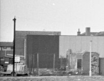
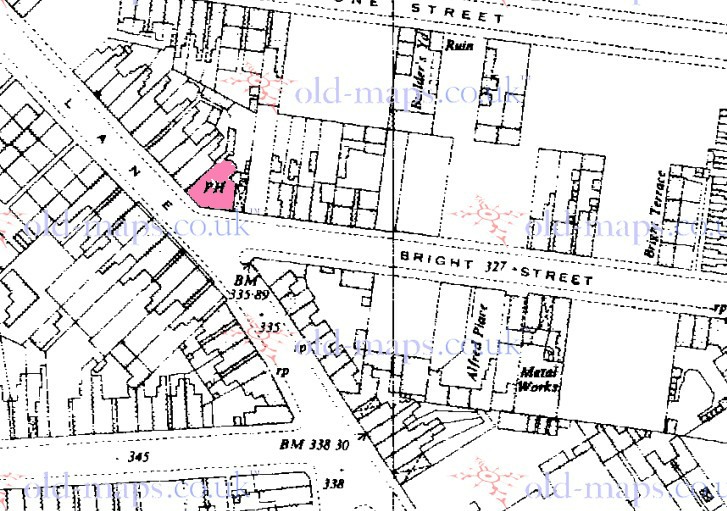
The Castle was on Bright Street, which no longer exists but ran between Church Lane and the junction of Beales Street and Vyse Street.
 
the school tower would have been behind the person taking the foto, and atkinsons very much to the left. behind the pub was a telephone exchange, with Lichfield rd to the right.
 
I'm not so sure it was the Castle as this was at no 2 Bright St on a sloping corner (see below) and this does not seem to fit the picture

map_c_1952_showing_the_Castle_pub_Bright_St.jpg
 
Last edited:
have to agree mike compering your photo with the map i dont think its the castle either

lyn
 
Yes, agree with you all - position and orientation all wrong. Could someone show us a section of map a little farther north? I'd like to see if the predecessor of The Adventurers, on Queens Road, fits the bill.
 
If standing in Queens Rd looking south, the building to the right of the pub in the photo, which might be the uni, appears in the right place and aspect on Google Earth, see view in #114, but I don't think there was any old pubs on the south side of Queens Rd.
I don't know why, I just have a feeling that Mike's photo looks towards the city centre ... but I could be wrong.
 
I'm afraid not viewfinder. As so often happens, someone has marked The New adventurers on google on the wrong side of the road !!. Found it though. It is a little disingenous , perhaps to state that it replaces an old pub. There was a pub on approximately the same site in 1938 (see below), but the maps of the 1950s and 1960s show an open space, so it could not be our pub. the 1951 map below is marked in red where the new pub is. In addition it was on a corner.


map_c_1951_showing_site_of_later_New_adventurers_pub.jpg


map_c_1938_showing_site_of_later_New_adventurers_pub.jpg
 
My next suggestion. think it might be off Dartmouth Middleway, around maybe Gt Lister Street. And maybe it disappeared when the Middleway was built. Viv.
 
Good work, mikejee - that rules out The Adventurers. I keep going back to the original photo to compare the street layout with an old A to Z: we have a road in the foreground running roughly east to west (assuming we have correctly identified Aston University). This runs parallel to the road on which the pub stands, separated by rough ground on which there is evidence of demolition. To the right of the pub is a receding terrace of houses, presumably on a street running southwards.

Is it possible that we are looking at a location rather closer to the University than we thought? Somewhere near Aston Cross - Portland Street? Holland Road?
 
This is why I think it's near Dartmouth Middleway. This view is along Lister St near the junction with Dartmouth Middleway. If you turn off to the left down Venture Way the angle looking towards Aston Uni is about right. The elevation is roughly about right too if the pub stood somewhere around Venture Way. Obviously Venture Way is a new road - now all commercial properties. You can't see much of the Uni from there. Managed just a couple of glimpses (red dots) of it from Venture Way. On the other hand. ...... could be completely wrong! Viv.
 

Attachments

  • image.jpg
    image.jpg
    205.8 KB · Views: 51
  • image.jpg
    image.jpg
    261.3 KB · Views: 48
Last edited:
image.jpg

Chimney stack could be the metal works near junction of Lister Street and Dartmouth Road on this 1917 Godfrey Edition Old Ordnance Survey map. Gosta Green is top left. So I place the pub at the junction of Lister Street and Dartmouth Street. I presume Dartmouth Street was widened when Dartmouth Middleway came into being.

Now wondering if the houses/pub were something to do with the Holt Brewery, there are Malthouses nearby as well as the Brewery and they sat in a very industrial area near to the canal. Viv.
 

Attachments

  • image.jpg
    image.jpg
    584.2 KB · Views: 25
Last edited:
Looking to the extreme left of the photo there appears to be some 1960s style housing possibly maisonettes as shown in this crop from the original photo.
12Acrop.jpg


Looking on Google Earth towards the city from Queens Rd some similar housing can be seen with similar vertical dark brick stripes by the windows. Unfortunately there are a lot of trees blocking the GE view. The image has been made b/w.
Capturetbw.JPG

These may not be the housing in the original photo but similar housing from the 1960s may be around that area.
 
theres none so blind as those who will not see. too much of a little clique for my liking. go and ignore the next daft sod who tries a little input,i knew that area like the back of my hand. tara.
 
No-one is ignoring you paulyx. You suggested a solution. According to maps and directpories it id not seem to fit. If that conclusion is wrong, then please say how that is. The point of the forum is to share knowledge. Do you think that the pub on the corner in the map is not the Castle?
 
I have just found the only picture i have of a Castle pub, not sure where it was situated in Birmingham, but certainly on a corner. Castle Inn.jpg
 
The maisonettes on Queens Roads were built in the early to mid 1960's, I had a school friend who move into them when they were first built, .......but they would be to the right as you looked at the Castle, unless the photo is a mirror image, trying to look at the steering wheels but I cannot make them out.....,
 
Hi aston lad - Thats an interesting theory about the photo being mirrored. I've had a close look at the steering wheels but nothing conclusive and nothing else in the pic to test whether it is mirrored. The maisonettes I mentioned in post #136 are shown in the aerial view below. They seem to be the only ones near there that have pitched roofs, all the others seem to have flat roofs.
Img_0620.jpg
 
think we need a little update on this one now folks..

mikes unknown pub pic on post 102 is definately a pub
paulyx on post 119 tells us it is the castle pub
mikes map on post 124 suggests that the castle was a corner pub which mikes unknown pub is not..
thanks to happyguy providing a photo of the castle pub it clearly bares out mikes map showing that the castle was a corner pub and also discounts the suggestion that the unknown pub is the castle..

will leave this running for another day or so in case we solve the
mystery after that i will move onto my next unknown photo..
 
Last edited:
The suggested location of this pub is about 2 miles from Aston Uni, not too far from the station. IF that is Aston Uni could it be seen so far away? My only knowledge of Aston is from making my way to and from "town" to Erdington for some thirty years either along Lichfield Road or the Express Way and I don't remember being aware of the Uni until much closer to town.
 
Referring to post #129 I was born in Queens Rd in 1930 next door to Atkinsons brewery (they owned the houses) and I can only remember only 2 pubs, the 'Avenue' at the very top, (Queens Rd/Park Rd junction) and the 'Queens Head' but the 'Queens Head' was sometimes referred to as 'the top queens' suggesting there was another pub of similar name lower down. In 1940 a landmine landed at the bottom of the road so it would have gone anyway. my Dads local was the 'Grosvenor Arms in Grosvenor Rd. Eric
 
I've looked for a photo of the Grosvenor Arms and there does not appear to be one anywhere - has anyone got a pic ?
 

Mike Kelly's 1964 proves there was a pub and it was M&B


QUEENS ROAD,
Aston (6),
Lovers' walk to 251 Park
road. MAP 1 1 ,12.
NORTH SIDE.
. . . here is Grosvenor rd ...
Mitchells & ButlersLta.
brewers
Atkinsons Brewery Ltd
MI Walker Peter Ltd.
mineral wateir mfrs
here is Church la
SOOTH SIDE.
... here is Grosvenorrd ...
70 J. & F. Wholesale Co.
Ltd. who. grocers
here are Church la.<k
Vicarage rd
124 D.M.T. TransportLtd.
haulage contrctrs
128 Daniels Mrs. Eliz refreshment
rms
14,6 Jones L. G. &Co.
Ltd. shopfittefs
146 Jones L. G.(Contractors)
Ltd. bldrs
 
Sorry. Have been away from my computer. Meant to put this c 1950 map on .It looks like the photo was taken from Brueton St

map_c_1950_showing_Castle_pub_at_junc__Brueton_st___Prospect_Row.jpg
 
John
Is that a pub or is it the Atkinson Brewery, which would have been taken over by then, but presumably still existed as a firm (thus also ahving the Atkinsons listed) ? The 1940 Kellys lists only the Queens Tavern (I think the Avenue was listed as Park Road), though the 1921 edition does list a beer retailer at 12.however it looks as if that , again, is on a corner, that with Vicarage Road. However this might explain Eric's memory of the "top Queens", this one possibly also being the Queens something or other.
 
The Grosvenor Arms wasn't on a corner, but in c1978 it still stood with houses immediately to the right of it, unlike the picture

I would like to see a picture of it though, if Phil has one.

map_c_1978_showing_grosvenor_Arms_2C_grosvenor_Road.jpg
 
Back
Top