I notice the houses #418 are below the road surface. So could these houses have been somewhere along the Viaduct? Can't spot anything as yet. Viv.
-
Welcome to this forum . We are a worldwide group with a common interest in Birmingham and its history. While here, please follow a few simple rules. We ask that you respect other members, thank those who have helped you and please keep your contributions on-topic with the thread.
We do hope you enjoy your visit. BHF Admin Team
You are using an out of date browser. It may not display this or other websites correctly.
You should upgrade or use an alternative browser.
You should upgrade or use an alternative browser.
New unseen photos with no locations
- Thread starter Astoness
- Start date
Viewfinder
master brummie
I notice the houses #418 are below the road surface. So could these houses have been somewhere along the Viaduct? Can't spot anything as yet. Viv.
The wall alongside the pavement looks substantial enough to become a bridge parapet...
oldMohawk
gone but not forgotten
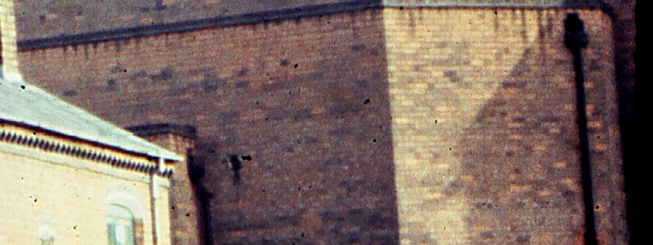
I can't see a window but I see dark coloured cap stones on the short walls around the flat roofs with the outlet to a drain pipe on the right. The small part of the building almost against the house is unusual and has the cap stones. The angled wall is unusual as it is not a boundary wall which is why I thought it might be the screen area of a cinema.Re. The brick wall, I think there's just a suggestion of a window or opening in the wall behind the roofline at that end. Viv.
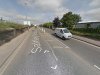
Thought I'd have a go at making a suggestion. The houses look squeezed into the space to me ie the houses are dropped down below the road level and probably abut the tall wall on the other side. If this was somewhere along the Saltley Viaduct it could be here, near what is now Saltley Business Park. (The building abutting the houses could be a non-residential commercial property). I've looked at the wall edging the Viaduct and further along it looks similar, albeit with less paint to cover up the graffiti. The wall next to the business park is new, so we can't compare it at that point. I also notice there's an access road in the photo - would this be to business properties behind the houses? All speculation, as usual. Viv.
Attachments
oldMohawk
gone but not forgotten
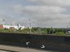
A 1937 aerial view of Wright St (3) and Woodbine Ave can be seen (1) and a chapel type building (2) which is a children's nursery today. It shows short terraces of houses at right angles to Wright St but nothing like the large brick building near the house.

From https://www.britainfromabove.org.uk/image/epw053099?x=409692&y=285879&extent=1000&ref=10
From https://www.britainfromabove.org.uk/image/epw053099?x=409692&y=285879&extent=1000&ref=10
I can't see a window but I see dark coloured cap stones on the short walls around the flat roofs with the outlet to a drain pipe on the right. The small part of the building almost against the house is unusual and has the cap stones. The angled wall is unusual as it is not a boundary wall which is why I thought it might be the screen area of a cinema.
Now see the capstones Phil. I thought that was a recess. Could only see the cap stones in magnification. Yes very unusual building. Viv.
There are more houses to the right - shadow on back wall(s) suggest house roofline, and pavement shadows make it look quite a tall building. But maybe the sun was low in the sky at the time. Viv.
oldMohawk
gone but not forgotten
I've been looking on https://www.smallheathcircle.co.uk/brum-cinemas.html and coincidently there was a cinema called the Victoria on the Coventry Rd but it closed in 1914. It is the red shuttered building in https://goo.gl/maps/RmNcV
Last edited:
Viewfinder
master brummie
I'm trying to make a connection between the wall alongside the pavement in Mike's photo (post 418) and the wall on Saltley Viaduct in the second photo posted by Viv (424). There are 18 layers of bricks in the latter, and a very similar number - if not the same - in the former. Layers of headers and stretchers are visible in the recent google image, but patterns in the earlier photo are indistinct.
Viewfinder
master brummie
I've been looking on https://www.smallheathcircle.co.uk/brum-cinemas.html and coincidently there was a cinema called the Victoria on the Coventry Rd but it closed in 1914. It is the red shuttered building in https://goo.gl/maps/RmNcV
An extraordinary variety of architectural styles shown on that link, OM. Look at the Tudor cinema, in Haunch Lane, Yardley Wood (opened 1929, closed 1963).
oldMohawk
gone but not forgotten
It certainly looks a functional building, not even the smallest window, unusual extensions and on Mike's latest enlarged pic I think I can see on the small part of the building next to the house, an outlet and drainpipe similar to the other drainpipe in the full pic. I wonder which was built first, the houses or the building? It looks like it could be one of those occasional unanswered questions on the forum, and on that subject what about this one here ...

The chimney is within the compound of the Birmingham Aluminium die castors it was a large foundry
Stretching front the front of ickneild port red and as far back as the ressor within the ressor if anybody ever went there by the cadetts
Hut was a viaduct which was like an over flow and feeder to the canal which trapped through and by passed the aluminium castorors
Foundry and back into the old canal ( main line )
The wall you see is actually the ressor boundary wall which if you was around the resservoir
And its high ground and you can over see the whole complex of the foundry and house and such on ickneild port road.
And some parts of rotten park. And the chimneys of such building as its been stated the salvage dept ETC,
The road neatest to rotten park was Oseler Street Then Clarke Street where my Mrs was brought up
On the corner of osler street was a rubber manu factor with a smaller chimney
Within the castors was a a high walk over bridge for the employees to get to a canteen and toilets which was about half way back heading in the direction
Of the ressor and beyond there was the employees car park then there was a huge hill of grass going the whole length of the
Massive ground you would try and walk up it but it was impossible to do so and that is the huge long wall you see and you would never get over it
Next to the castors was a coal wharf and the inlet for badges to unloand metals and the coal yard
Ten years ago this was all mentioned on here and later that family turned it into a scrap yard back in the sixtys
When I was 17 years old I worked in that foundry as a linisher
My brother worked across the road At Docker brothers paints for years which went all down the rotten park to the channel in those days
The main canal coming from gas street up to the black country and gaulton bridge and railway station
Best wishes Astonian,,,,,Alan,,,,,
Radiorails
master brummie
The first time I saw the last pic of post 410, which is repeated in post 418 and enlarged in post 431, I believed the large wall at the rear to be that of a railway or canal viaduct with another building, of a lean-to style added to it. The lean-to building seems to have a flat roof which might support this idea. Another facet is the road that the houses are in goes where? I suggest it goes beneath an arch of a viaduct.
oldMohawk
gone but not forgotten
The buildings attached to the far wall are using the same bricks and look to be part of the same structure. Capping stones on all walls look the same. There appears to be a small hole in the wall when the lower right area of the pic is lightened although I can't see a drain pipe there. The flat roofs of the building look like ashphalt covered and with parapet walls. The 1937 pic in post#425 (which I've made to appear in this post) shows several groups of houses at right angles to the main road appearing to go nowhere and some ending at buildings which are not houses.It seems the builders sited houses almost anywhere in the space between the roads and they probably all had narrow access roads.

Although it is not the same area there are interesting pics of houses against the Saltley Viaduct in a forum thread here
https://birminghamhistory.co.uk/forum/showthread.php?t=38220&p=465805#post465805
Although it is not the same area there are interesting pics of houses against the Saltley Viaduct in a forum thread here
https://birminghamhistory.co.uk/forum/showthread.php?t=38220&p=465805#post465805
Last edited:
Viewfinder
master brummie
The chimneys on the cottages in that short terrace are distinctive: six stacks, with two at each end of the row. I'm trying to spot this arrangement in your aerial photo, OM.
Old Boy
master brummie
Believe it or not, that chimney is a school, Somerville School in Somerville Road. Have no idea why it would need such a large chimney. Used the architectural features and the chimney to spot the terrace. Viv.
Hi Viv,
I do not think that it is a chimney. I went to Somerville Road School and always thought of it as a tower but I never heard of anyone going up the tower. I believe the school is still there so perhaps someone could find out for us. Never did I see any smoke coming out of it. I am sure it was not a chimney.
Chris Beresford (Old Boy)
Phil
Gone, but not forgotten.
Hi Viv,
I do not think that it is a chimney. I went to Somerville Road School and always thought of it as a tower but I never heard of anyone going up the tower. I believe the school is still there so perhaps someone could find out for us. Never did I see any smoke coming out of it. I am sure it was not a chimney.
Chris Beresford (Old Boy)
Most Schools had a tower or a steeple, I always thought that these had something to do with fresh air circulation, if you can imagine what was like in Victorian days when most of these schools were built.
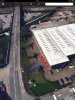
This is the position I suggested for he cottages in photos #4 and #5 in Mike's post #410. The blue dots being cottages and the red dots being the tall wall. I suggest it's roughly there as I think the wall is a commercial /industrial building and the land could still be classified today for commercial/industrial use as a business park. Vv.
Attachments
Phil
Gone, but not forgotten.
This is the position I suggested for he cottages in photos #4 and #5 in Mike's post #410. The blue dots being cottages and the red dots being the tall wall. I suggest it's roughly there as I think the wall is a commercial /industrial building and the land could still be classified today for commercial/industrial use as a business park. Vv.
Vivienne
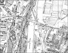
I can tell you from memory that there was no housing either side of Saltley Viaduct, just gasworks, railway sidings, public works dept & commercial properties, but here's a map from around the time Mike was taking his photos so you can see for yourself.
Attachments
Radiorails
master brummie
A brick built Victorian church? There must be one or two in that area.
oldMohawk
gone but not forgotten
Maybe old maps from the Wright St and Cato St areas could be looked at to see if buildings with the same plan shape as the one in the photo could be spotted next to houses at right angles to a street.Vivienne
I can tell you from memory that there was no housing either side of Saltley Viaduct, just gasworks, railway sidings, public works dept & commercial properties, but here's a map from around the time Mike was taking his photos so you can see for yourself.
Radiorails
master brummie
Most Schools had a tower or a steeple, I always thought that these had something to do with fresh air circulation, if you can imagine what was like in Victorian days when most of these schools were built.
Presumably to hold a water tank, as the mains would be of insufficient pressure for a large user.
Maybe old maps from the Wright St and Cato St areas could be looked at to see if buildings with the same plan shape as the one in the photo could be spotted next to houses at right angles to a street.
There is a video of Cato Street. Dunno if its any use to anyone
https://www.macearchive.org/Archive...to-street-in-birmingham/MediaEntry/36052.html
Nice video Richie. Will study it later.
A few things crossed my mind about Mike's 4th and 5th cottages. The first is they're built of different brick to the regular bricks used in the area (is it London brick). The second is they remind me of artisan cottages built for railway workers. Sometimes they were squeezed in alongside railway property. Could these be? Viv.
A few things crossed my mind about Mike's 4th and 5th cottages. The first is they're built of different brick to the regular bricks used in the area (is it London brick). The second is they remind me of artisan cottages built for railway workers. Sometimes they were squeezed in alongside railway property. Could these be? Viv.
oldMohawk
gone but not forgotten
I've looked at available aerial photos and also cannot find any houses near viaducts or embankments in that area.
Like others I'm reduced to looking at small details in the pics and they probably won't help ...
There are two terraces of only two houses at right angles to the road.
The houses have unusual small windows between the bedroom windows over their front doors . I can't recall previously seeing houses with that window layout.
The one terrace has the large building really close to it. The flat drained roof over the angled part of the building suggests there is a room underneath. Also the shadow on the right wall seems to indicate that the high wall finishes just out of shot.
There are out-houses with chimneys on the house gable ends adjacent to the road.
The houses have small front and back gardens and narrow access roads.
The houses have rooms each side of their front doors and so accomodation is not small and not cramped.
The street light in photo5 is different to the one in photo3 pics and could indicate a different road or even area.
Viewfinder
master brummie
Nice video Richie. Will study it later.
A few things crossed my mind about Mike's 4th and 5th cottages. The first is they're built of different brick to the regular bricks used in the area (is it London brick). The second is they remind me of artisan cottages built for railway workers. Sometimes they were squeezed in alongside railway property. Could these be? Viv.
Good thinking, Viv. It's difficult to assess true colours in pictures 4 and 5 of Mike's sequence because his film didn't record faithfully the contrast between sunlight and shadow - and there has been a hefty colour shift as the film or print has degraded in the intervening 45 years. Picture 3 is intriguing: the house on the left edge is red brick, while the focus of Mike's attention is soft yellow: Peterborough, or 'London' brick. Yet this has been painted or glazed in a deep crimson colour from pavement level to chest high.
Of course it's quite possible that between Small Heath and Cato Street North, Mike went to Watford without telling us...