-
Welcome to this forum . We are a worldwide group with a common interest in Birmingham and its history. While here, please follow a few simple rules. We ask that you respect other members, thank those who have helped you and please keep your contributions on-topic with the thread.
We do hope you enjoy your visit. BHF Admin Team
You are using an out of date browser. It may not display this or other websites correctly.
You should upgrade or use an alternative browser.
You should upgrade or use an alternative browser.
Location wanted for this bus if possible
- Thread starter Grea
- Start date
- Status
- Not open for further replies.
Phil
Gone, but not forgotten.
Could it be possible that this service has been diverted to avoid road works and is not on a familiar route?
Yes badpenny this has already been discussed as a possibility.
There was also a bundy clock on the number 8 route outside the Brewers Arms at the junction of Highgate Road and Stoney Lane in Sparkbrook.

Radiorails
master brummie
There is a bus stop (not covered) and people seem to be waiting. At the time of the photo the clock might well have been moved given the narrowness of the pavement. There was a good deal of road improvements in the 1960's onwards. The last clocks were removed in 1997 I understand.
Last edited:
Gerry Cannell
master brummie
Such a sad end to a lovely old vehicle.....Hi Maurice,
I noted the CVP 108 number plate on the bus and had a search for a bus with that number and good old Google found it in scrapyard !
Phil
View attachment 130390
Curly
master brummie
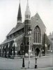
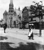
This is my current thinking, but like you cannot find any photos of St Margaret's or any views in Ledsam St or Gt Tindal St showing the tower over other buildings.Looking behind the bus, the road appears to sweep around to the left slightly with a building (shop?) protruding into the image (behind the bus shelter).
Could the building be St. Margarets Church (Ledsam Street) ? the road configuration looks correct but unfortunately I can find no picture of the church (shown in yellow) which was demolished in the 50s. Not sure why the bus would be on this road but I'm sure other people could advise on this. John
Radiorails
master brummie
By goood fortune CVP 207 (1107) still exists and is a runner. Can be seen at Wythall Transport Museum.Such a sad end to a lovely old vehicle.....
brummy-lad
master brummie
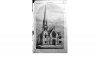
To keep this thread alive (mainly because I don't like to be defeated on this location) I have attached a picture of St Matthias Church Farm Street Hockley (now demolished)
In it's favour:
1. It is right next to the road.
2. The spire is a perfect fit.
Against:
Main building does not seem to match although this is a very old pic and perhaps some alterations took place. John
In it's favour:
1. It is right next to the road.
2. The spire is a perfect fit.
Against:
Main building does not seem to match although this is a very old pic and perhaps some alterations took place. John
Attachments
Radiorails
master brummie
Two things appear to rule out Farm Street.
1. No small pinnacles at the tower base.
2. As far as I am aware the Inner Circle 8 did not run along Farm Street. It ran further north in Nursery Road, Gerrard Street and Park Lane. At the time of the photograph of course.
1. No small pinnacles at the tower base.
2. As far as I am aware the Inner Circle 8 did not run along Farm Street. It ran further north in Nursery Road, Gerrard Street and Park Lane. At the time of the photograph of course.
brummy-lad
master brummie
Hi Alan,Two things appear to rule out Farm Street.
1. No small pinnacles at the tower base.
2. As far as I am aware the Inner Circle 8 did not run along Farm Street. It ran further north in Nursery Road, Gerrard Street and Park Lane. At the time of the photograph of course.
Thanks for the response, There are pinnacles but they are very difficult to see (above each window), they appear to correspond nicely with the original pic in post 1.
I thought perhaps with all the work going on in Birmingham at that time then perhaps the bus was 'off-route'.
I will come back to this thread again it really bugs me not to find out where it is. John
Last edited:
hi alan actually the no 8 did at one time run along farm st but only a tiny part of it....it came from icknield st over to farm st ..past my old school. then a sharp left into villa st did a right into nursery road and into gerrard st and onto park lane...st matthias was on the corner of wheeler st and farm st so quite a distance from the the villa st turning...then when the hockley fly over was built the route changed to missing out farm st...it came out of icknield st into hunters road then a right to pick up nursery road im afraid its not st matthias church..keep trying lads")
lyn
lyn
Radiorails
master brummie
Yes, it seems the dear old No. 8 has been the subject of quite a few detours in its days, due to road works, WW2 and re-development. I guess it made it interesting for the drivers but maybe not its passengers. 
Grea
master brummie
Thanks for your enthusiasm, I spent all day on it yesterday but no luck, studied the whole of the No 8 route. I can’t give up eitherTo keep this thread alive (mainly because I don't like to be defeated on this location) I have attached a picture of St Matthias Church Farm Street Hockley (now demolished)
In it's favour:
1. It is right next to the road.
2. The spire is a perfect fit.
Against:
Main building does not seem to match although this is a very old pic and perhaps some alterations took place. John
brummy-lad
master brummie
I've been all around the No.8 bus route twice using a 1950s map and found nothing, that is why I've come to the conclusion it must have been on a diversion. I think the main feature is how close it is to the road.
It's hard to believe given the very unusual cascading window and the spire with 8? pinnacles that an image can't be found on Google. John
It's hard to believe given the very unusual cascading window and the spire with 8? pinnacles that an image can't be found on Google. John
Radiorails
master brummie
I mentioned this school some while ago. The building has a spire, pinnacles and was on/close to the 8 route.I mentioned, in an earlier post the former school.
It can also be seen in this thread - ~Post 265
https://birminghamhistory.co.uk/forum/index.php?threads/icknield-street-alert.10620/page-14
View attachment 130625

brummy-lad
master brummie
Brilliant image, thanks for that and also conclusive evidence it's not the building we're looking for. JohnAt least St Mattihas church is directly on the road and it has a spire (of sorts) in this aerial view dated 1950 .... but I think not the one we are looking for ....
View attachment 130966
Lumpammer
master brummie
If it was a diversion, why is there a permanent bus stop?I've been all around the No.8 bus route twice using a 1950s map and found nothing, that is why I've come to the conclusion it must have been on a diversion. I think the main feature is how close it is to the road.
It's hard to believe given the very unusual cascading window and the spire with 8? pinnacles that an image can't be found on Google. John
Radiorails
master brummie
That was probably a bus stop on the 69 Lozells route as it traversed Wheeler Street.
oldMohawk
gone but not forgotten
Google found it for me also ...
A view of New Street notable for the bus CVP 108 which in this pic is on the 3A route but was in an unknown location on the Inner Circle route in another thread https://birminghamhistory.co.uk/for...ed-for-this-bus-if-possible.49551/post-634018

Bob Davis
Bob Davis
Very shiny and repainted looking, post war because of the buses further up New Street, probably Harborne Garage because of the route, was the horse drawn vehicle behind one of the railway delivery vans, I think, and I am ready to be corrected, GWR had some of that design. The question is, is this 1008 just after the war or when it had been revamped as one of the tram replacement substitutes? Whilst guesses could be made at one or two of the cars, unfortunately no obvious post war cars to help the dating. Still a good picture thoughGoogle found it for me also ...
Bob
Hi Phil jusst what is the questian of this route and this bus and which picture of the bus thats in question we are trying
to seek out and resolve ? . becaus ridgee i am getting confused here .
May i had yes the info on your previos thread above mine is true it did excactly go the course it said but it never went the full extent of st lukes road as it turned by the church it was a very narrow road and it more or less turned back to belgrave road and it was just pasin the round about and as it get back o belgrave road they had built the first two storie massionettes and then continued up the belgrave road but also the st lukes church had a gold brained brick on the right hand of the church it was only noticable when on the bus up stairs as the bus was very close to te walls as it was trying negoite and arond the twisting for the bus, and the only ime i have experiences on the eight bus was when they diverted the eight coming to springhill when monument road was dug up for laying pipes all the way down to springhil so it was divered down ickneil port road and turning down at dudley road back to springhill
the other photo is springhill whether you like it or not its a fact and in those days the bus wnt and down to hockley brook passing the school windows up and down all day if you never go off at the flat you woul havegot at the brook this side and itb bwould have gone over the big junction to thee big pub and down to farm street and turned left and right onto gerrarard street eventual years later the bus stopp goin down by farm streeet school as they was planning to alter the brook and blocked that road off and then went towards hunters way and headindin gerrard street
Radiorails
master brummie
Bus CVP 108, in New Street, is a 1950 photograph,
Not wishing to be rude but we do seem to be treading a path already well trodden.
We need new ideas!
Not wishing to be rude but we do seem to be treading a path already well trodden.
We need new ideas!
brummy-lad
master brummie
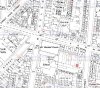
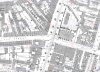
Another possible contender Wycliffe Baptist Church or Wycliffe Chapel on the Bristol Road, the tower looks correct. I don't fully understand if they are the same building and the positioning? The map is 1889. An aerial view could help if available. John
Attachments
- Status
- Not open for further replies.