-
Welcome to this forum . We are a worldwide group with a common interest in Birmingham and its history. While here, please follow a few simple rules. We ask that you respect other members, thank those who have helped you and please keep your contributions on-topic with the thread.
We do hope you enjoy your visit. BHF Admin Team
You are using an out of date browser. It may not display this or other websites correctly.
You should upgrade or use an alternative browser.
You should upgrade or use an alternative browser.
Brilliant photos! Your photos are so good Lynn I'm struggling to place most of them!! lol. Given me lots to chew over here. Correct me if I'm wrong, but wonder if Kettlehouse Farm would have been somewhere around where the KIngstanding shopping centre and library now stand on the Circle ? Would be a good position for a brewhouse. Anyone know if the house in view in the Pheasey Farm pic is the farmhouse. Looks quite grand. Love the tractor too.Viv.

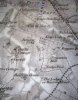
morning mike..is that shady lane on the right of your map then...must say it does look a bit different but you know me...hopless at working these things out..mike would you be able to post another map showing more of the area please...
thanks mike...
thanks mike...
lynne webb
GONE BUT NOT FORGOTTEN
I noticed an old house or cottage on Aldridge Road, opposite the exit of Asda, I must have passed it many times but missed seeing it.
Lynne.
Lynne.
Still can't post via my laptop and coppermine so giving Tapatalk another go to post the 1834 map I mentioned. This section shows Lodge Pool and I think Lyn's Pool Farm Cottages are alongside. Interesting too that Warren Farm seems to have been known as Lodge or Warren House.

Lynne - been trying to find your cottage on Aldridge Rd on streetview but can't see it. Can you tell me where exactly the Asda exit is, as I don't know the shop. Many thanks. Viv.
Lynne - been trying to find your cottage on Aldridge Rd on streetview but can't see it. Can you tell me where exactly the Asda exit is, as I don't know the shop. Many thanks. Viv.
Attachments
Think I'd better wait Lyn until I can post via coppermine. But when I can I'll drop this map and the earlier one into the original places. Really enjoying this thread. A little aside. Just been reading that the new 1930s residents of Kingstanding called it 'Little Russia'. This was because it was so high up and caught the blasts of cold air from Russia. Brrrrrrrrrrrrrrrrrrrrrrrrr... Viv.


lynne webb
GONE BUT NOT FORGOTTEN
Viv, going from Shady Lane towards Queslett Road on the right is the Oscott Club and this cottage is just past there before the shops. The Asda exit is on the left just before the big island. I was going to say you cant miss it but I have for years.
Lynne.
Lynne.
Lol Lynne! Just spent a lovely wet afternoon touring the area on Google streetview without even stepping outside! Will go and take another look. Thanks for the details.
Wow Lyn. These again are superb photos. Gives us lots to think about. Some of these farms look massive with very fancy architecture. They must have made a lot of money from the land around Kingstanding. Think it probably has very fertile soil. Remember digging in our garden, it was always very dark, rich soil and plants grew well, unlike the chalky rubbish we have down here! Speaking of soil that leads me to a little tale about the Circle mound and Kettlehouse Farm. Don't know if it's true but this is from Thefreelibrary.com:
"In 1930, George Podmore, the vicar of Hamstead, wrote that 20 years previously, an old man of almost 80 had told him that when Perry Common had been enclosed at the start of the 19th century, the tenant of Kettle House Farm had brought horses, wagons and men to cart away the knoll. Lord Calthorpe was informed and came at full gallop from Perry Hall to stop it".
Conjours up quite an image! Viv.
lol viv what an image that conjours up indeed..you can just imagine lord calthorpe going at full belt to stop the removal of the knoll...dont know about good growing soil viv but ive got red ants on the one side of my garden..cant grow a thing there so i put tubs on that side.i was just thinking that maybe tomorrow i will take a pic from the top of warren farm road and post it..still go a few mor pics to scan tomorrow.when i look at that pic of manor farm it begs the question did it really need to be demolished...mind you ive said that about many many buildings..
lyn
lyn
oldMohawk
gone but not forgotten
I was wandering around the Kingstanding area (lazy way on streetview) and Hawthorn Road used be a road I knew well. I notice the library is still there at the junction with College Rd although it is probably just in Perry Common. That was the first library I ever borrowed books from, and I remember how strictly run it was. At the top end of Hawthorn Rd, Google's cameras act very strangely - in a few yards drive along the road, a Woolworth's disappears, and a Tesco Express appears, but I suppose anything is possible in Googleland. I seem to remember a Peacocks store where Tesco is now.
oldMohawk
gone but not forgotten
Hi Jean,
Hawthorn Rd seemed to have a shop for everything. I remember an Air Training Corps place which had a Spitfire or Hurricane on display.
I had a look for Kingstanding Baths but it seems to have gone. I nearly drowned there - jumped off top board before I could swim - could not reach the side until some swimmer pushed me.
On a hot summer's day they allowed a 30 minute visit and then out - the queues were very long.
Phil


I think the school marked at the bottom left of Mike's second map must be Great Barr school. Didn't think the school was that old, but must be as the shape looks the same as the building today. Used to be able to see this from our bedroom window. We were on the top of a hill in Kingstanding and the school was on the top of a hill opposite, so the space in between must have effectively been a valley.
Oldmohawk. Loved Perry Common Library. It had oak bookcases, and heavy free-standing radiators. Lovely and warm in winter. The children's section was on the right as you went into the building, the bookcasses were all a smaller version of the adult bookcases. To the left as you went into the library was the newspaper reading room with special reading boards for newspapers. Next to this was another room, but can't remember what that was for. They had a good range of hobbies magazines for loan too. Straight ahead of you as you entered the library was the librarian's desk, one side for checking in and the other side for checking out. Every piece of furniture and fitting in that place seemed to be made of wood. Yes it certainly was a very strictly run place. The librarian's announcement of "silence" really meant silence. Spent many, many hours in there. Think you're right that it's more Perry Common than Kingstanding, but I expect many people from Kingstanding used this library. I preferred it to the modern Kingstanding Library. Viv.
Oldmohawk. Loved Perry Common Library. It had oak bookcases, and heavy free-standing radiators. Lovely and warm in winter. The children's section was on the right as you went into the building, the bookcasses were all a smaller version of the adult bookcases. To the left as you went into the library was the newspaper reading room with special reading boards for newspapers. Next to this was another room, but can't remember what that was for. They had a good range of hobbies magazines for loan too. Straight ahead of you as you entered the library was the librarian's desk, one side for checking in and the other side for checking out. Every piece of furniture and fitting in that place seemed to be made of wood. Yes it certainly was a very strictly run place. The librarian's announcement of "silence" really meant silence. Spent many, many hours in there. Think you're right that it's more Perry Common than Kingstanding, but I expect many people from Kingstanding used this library. I preferred it to the modern Kingstanding Library. Viv.
Viv, going from Shady Lane towards Queslett Road on the right is the Oscott Club and this cottage is just past there before the shops. The Asda exit is on the left just before the big island. I was going to say you cant miss it but I have for years.
Lynne.
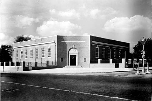
Is this the one Lynne? Viv.

I was wandering around the Kingstanding area (lazy way on streetview) and Hawthorn Road used be a road I knew well. I notice the library is still there at the junction with College Rd although it is probably just in Perry Common. That was the first library I ever borrowed books from, and I remember how strictly run it was. At the top end of Hawthorn Rd, Google's cameras act very strangely - in a few yards drive along the road, a Woolworth's disappears, and a Tesco Express appears, but I suppose anything is possible in Googleland. I seem to remember a Peacocks store where Tesco is now.
Just tried it out on streetview and, yes it's very strange! I have quite a few memories of the shops too. Yes where Tescos Express now stands was, in the 60s, Littlewoods store. It had those low flat counters with clothes laid down in lines. The counters had glass partitions on them for different items. Seem to remember they had these amazing light fittings in there too. Quite old looking - I think they were gas fittings with a chain hanging down, to light them maybe? Woolworths was next door and I'm sure I didn't imagine this, but they sold some food items, dry goods like jam and sugar. Another shop I remember was Shoefayre - where Shoe Zone is now. Bought I don't know how many pairs of shoes from there. Further down in the 50s there was George Masons grocery shop - possibly now the bread shop. It became one of the earliest supermarkets there. Well when I say supermarket, it wasn't like the large-scale later ones, it just had lots of shelving units with aisles and you used a basket to put your items in! There's been a pet shop along there too for a very, very long time. Going onto the other side of the road, I think Mama Mias or next door was a launderette in the 60s - regular visit there every Friday night. And further round near Warren Farm Road was Foster Bros - now Big Johns, next to Lloyds Bank. There's a little section at the end of the Lloyds Bank building on Warren Farm Rd which used to be a wool shop. It no longer has a shop front. On Kingstanding Road I remember going into the Territorial Army building with my mum and dad to vote. It was used as a polling station for elections. Well all these photos have certainly sparked off some memories!! Viv.
lynne webb
GONE BUT NOT FORGOTTEN
That looks like it Viv, I didn't get a very good look because the traffic is so heavy there so we couldn't stop. It looks a lot older than the other houses nearby.
hi mike thats not working for me..all i get is a whole page of mixed up letters...
Hi Lyn see if this pic of the 1921 map works for you. Viv.
View attachment 72375
