Petethebrummie
New Member
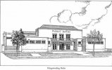
was wondering if anyone had interior pictures of the old Kingstanding swimming baths or Warren Farm school
 birminghamhistory.co.uk
 birminghamhistory.co.uk

Your right Viv, swim a length and get a free pass. I had one for Erdington Swimming Baths too and used it to death.I remember the baths. Did my test for the free swimming pass at Kingstanding baths - was at Kingsthorne Junior School at the time. I didn’t even realise I’d done it. You had to be able to swim, I think, one length of the main bath. Viv.

The second of the Department’s Baths to be erected in the newly developed areas of the City was at Warren Farm Road, Kingstanding. Opened on the 31st March, 1938, this establishment is well set back from the road with a turfed forecourt, harmonising with the general layout of this part of the district. The facilities available are similar in every respect to those at Northfield Baths, the large swim being 100ft. by 35ft., graded from 3ft. 3in. to 10ft. 2in., and the learners’ pool 36ft. by 18ft., graded from 2ft. 3in. to 4ft. 6in.
Yes, thats how I rember it.I think the cafe looked down onto the small swimming pool. Viv
Thought I’d dreamt about handing in your clothes in those baskets re post #11. I remember that too ! In the cubicles you’d always carry on conversations with your friends next door while you changed into swimming costumes.
In the cafe one of the very large tubs (I mean really really large) for Cow & Gate chocolate mix was used as a bin for rubbish - like crisp packets and chocolate wrappers.
Opposite the baths as you came out was a large grassed roundabout which I think was for traffic control
That roundabout had a brook running through it that came from Finchley park, we walked from there all the way up to the park under the tunnels.

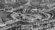
I had looked at that map and the aerial view and I can see now that what I thought was a row of houses is actually the main pool building and on the back might be a boiler room and chlorination plant. It looks like the aerial pic has the only view we have of the baths,I am not familiar with the area, but, from the c 1937 map, aren't the baths the building marked with an arrow?
View attachment 157916View attachment 157917
I thought the Welfare Centre was on the other side of the island. Got me thinking now.I have a vague feeling there was a view on Google Streetview of the Baths, obviously quite a few years ago, before it was demolished. Or maybe it was the old Welfare Centre (next door ?). Could be imagining it. Viv.
