• Welcome to this forum . We are a worldwide group with a common interest in Birmingham and its history. While here, please follow a few simple rules. We ask that you respect other members, thank those who have helped you and please keep your contributions on-topic with the thread.

    We do hope you enjoy your visit. BHF Admin Team

Harborne

  • Thread starter Thread starter mike-g
  • Start date Start date
What is they say about great minds? ;)

The 1911 census has at 85 Vivian Rd, Harborne, Worcs (the next door house is 87 in today's view):
George Douce, age 70, Fruiterer and Grocer, born Lea Marston, Warwickshire.
Mary Ann Douce, 66, wife (of 46 years - see below!)
Florence Douce, 39, daughter
Arthur Douce, 29, son - both assisitng in business;
Beatrice Mary Douce, 22, a Milliner's assistant.

George Douce married Mary Ann Penfold (I wonder if any relation of mine??) in Meriden district, 3rd quarter 1864.
In the period to 1911 they had 12 children, 7 of whom survived.

In the 1891 census, I think they were at the same property - certainly the same area - as 65 Lodge Rd, which is described as "From New Inns to Park Road".
If the "New Inns" is what is called "THe Junction" now, and "Park Road" is Harborne Park Road, then it is. Interestingly, it was Staffordshire back then.

Lodge Road again in 1881, but High Street in 1871.

In 1861 20 year old George and his parental family appear twice in the census, but both appear to be the same place, described in both as "Duston or Holston Grange", one is Lea Marston, Warwickshire; the other Merevale, Leicestershire. By elimination I think the real location is the Grange in Atherstone Road, Hurley - now the site of a farm and modern housing.
Mary Ann Penfold, 17, was a domestic servant in the well-to-do household of James and Eliza Woodfield of Croydon. Now if the woodfields knew and visited the family at Hurley grange...but that's just guessing.
 
Last edited by a moderator:
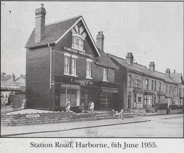
View attachment 56165This is where i lived,2nd house along after the little shop,
Beaumont Removals my brother worked there,such a long journey:)and i worked in the Coop which was just beyond the little broken wall and washing on the line.
41012_1430537090623_.jpg
 
Last edited by a moderator:
What is they say about great minds? ;)

The 1911 census has at 85 Vivian Rd, Harborne, Worcs (the next door house is 87 in today's view):
George Douce, age 70, Fruiterer and Grocer, born Lea Marston, Warwickshire.
Mary Ann Douce, 66, wife (of 46 years - see below!)
Florence Douce, 39, daughter
Arthur Douce, 29, son - both assisitng in business;
Beatrice Mary Douce, 22, a Milliner's assistant.

George Douce married Mary Ann Penfold (I wonder if any relation of mine??) in Meriden district, 3rd quarter 1864.
In the period to 1911 they had 12 children, 7 of whom survived.

In the 1891 census, I think they were at the same property - certainly the same area - as 65 Lodge Rd, which is described as "From New Inns to Park Road".
If the "New Inns" is what is called "THe Junction" now, and "Park Road" is Harborne Park Road, then it is. Interestingly, it was Staffordshire back then.

Lodge Road again in 1881.
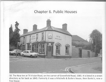
The new inns was on the corner of Greenfield Rd and Vivian Rd, i think
 
Last edited by a moderator:
What is they say about great minds? ;)
...
In the 1891 census, I think they were at the same property - certainly the same area - as 65 Lodge Rd, which is described as "From New Inns to Park Road".
If the "New Inns" is what is called "THe Junction" now, and "Park Road" is Harborne Park Road, then it is. Interestingly, it was Staffordshire back then.

Lodge Road again in 1881, but High Street in 1871.

I have always known the New Inn https://maps.google.co.uk/maps?q=52...d=ZbxmFkpGXCz0hkU-1XWfhg&cbp=12,334.02,,0,5.7 as The New Inns so I imagine it was originally called that but don't know why the plural.

There used to be a range of back-to-backs between the Church and Greenfield Road. I don't know if there was a road through the estate called Lodge Rd where present day Waterward Close is?

Would be interesting to find out more...

Was the Co-Op next to the TSB Bank which is now the highly-rated Henry Wong?
 
It was by the bank don't know what the bank was called, ssh i found your roundabout
 
I've added more on the Douce family to post #149. George Douce was a gardner in his 20s, and a Fruiterer and gardner when first in Harborne, which suggests a shop or smallholding. When was the Vivian Rd propery built, any ideas? Were the Douces the first occupants of the shop, from when it was built?
So much fascination from just one old photograph.

Yes fascinating indeed. I think the architecture of the building pictured is very early C19th say 1820-1840. The back-to-backs behind it were of a similar vintage, possibly earlier.

Harborne was part of Staffordshire and also subsumed Smethwick. They shared a Workhouse opposite the Old House At Home. Harborne seemed to be famous for its gardeners and fruiterer's (esp Gooseberries cf "Bobby" earlier this thread). I wonder what exotic fruit consisted of at that time
 
Spot the errors on the present pub sign at the New Inns pub sign board which shows a view of it c WWI time

1) Picture shows it as a Banks pub at a time when it would have been an M & B pub
2) Bus outside is a London General Omnibus Co which certainly did not have a route runing past there.
3) Bus has a reversed staircase and platform so passengers have to board from the offside.

Whilst I agree with your points, it would have been possible to see a (former) London General bus passing very close by for a short time - in 1926, when the Outer Circle route was completed a few old ex-LGOC 'B' type buses were loaned by the bus maker AEC pending the delivery of the double deckers ordered for the new service. They ran in their former owner's red & white livery as in the pub sign - but the stairs did curve the other way! They would have gone along Harborne Park Road, about 1/4 mile away.

The sign is visible on Google maps streetview, here.
 
Sorry I wanted to post a photo of the pubsign but I only have that on 35mm transparency and have not yet got round to buying a scanner. Thanks Lloyd for the info about the LGCO buses hired in for the Outer Circle.

The registered name of the London General was Compagnie Generale des Omnibus de Londres
 
Last edited by a moderator:
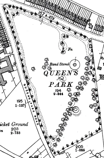
Her is queens park c 1903. i think the pond must be the little round thing three quarters down by the path
M ike

map_c_1903_queens_park_harborne.jpg
 
Thanks Mike - I am trying to cast my mind back and think what was there when I knew it - I think it was the lower swings with putting green behind but not 100% sure
 
Yes that must be the circular pond, the bandstand is visible through the trees, as are some houses on Court Oak Road in the 'general' view.
Compare a present day aerial view, other than the pond, bandstand and what might have been a fountain ('Fn' on the plan) it is much the same as before.
 
Thanks Lloyd - I forget the aerial view is available when streetview isn't (the tech is all voodoo to me).

Looks like the lower swings have gone now under a car park. Bandstand is no more. I think the Fn was a water drinking fountain in my day (but whether it replaced the decorative one I don't know). I favour the round thing 3/4 way down the path
 
Here are some other people connected with Harborne and commemorated by Birmingham Civic Society Blue Plaques (not inc David Cox & W.H.Auden above):

Sir Granville Bantock - Composer - Metchley Abbey, 93 Metchley Lane, Birmingham, West Midlands B17 0JB (Was there ever a real Abbey?)
...

I am wondering if the Metchley Abbey was the grand Metchley House on English Heritage https://www.englishheritagearchives...tsaj.aspx?t=Quick&l=exact&cr=metchley&io=true - I feel sure it is nearby
 
Drainage work has been carried out recently in Queens Park in the area where the pond was as part of the general refurbishment that is being done on the park.
 
I remember Queens Park when I was a child in the 1940s. There were the usual swings, a roundabout and a slide. There was a drinking fountain where you pessed a button and the water bubbled up - just the job for thirsty children. I remember the bandstand and the putting green, also the bowling green. The flower beds were lovely and the park keeper had a kind of Lodge at one of the entrances. Lots of events were held in the park for peoples' enjoyment such as baby shows etc. which I think took place in the 1930s. Anthea.
 
Queens Park was my favorite - OK the ONLY park I went to really. Such innocent joys as the putting green (18 holes of flat grass), the big cast iron roundabout and yes that drinking fountain (I imagine Health & Safety have done away with that little joy - I would never ask for water normally but the first stop in the Park was generally to drink at the fountain). I seem to remember there was a derelict house https://maps.google.co.uk/maps?f=q&...52.459693,-1.97015&spn=0.000786,0.001971&z=19 to the side of the park too, whose garden must I guess have been turned into the putting green & tennis courts
 
This green was the centre of the village, and was known as Harborne Town. Here the roads from Smethwick, Northfield and outlying districts converged and was the location of old inns, the smithy, and for a short time the village lock-up where local miscreants were swiftly dealt with https://www.birmingham.gov.uk/cs/Sa...092585864&pagename=BCC/Common/Wrapper/Wrapper

As well as bear-baiting, various other sports involving fighting cocks and dogs were a regular fixture. These animals were trained by the occupiers of Matchcraft cottages on Harborne Heath (High St).

These cottages were built over by the Masonic Hall in 1879 which housed the Harborne Lodge (Tudor 1792) of the Province of Staffordshire. The architect was A. E. Phipson, a local man living in Metchley Lane, who in partnership with his son, is credited with designing several buildings in Harborne of a similar date.

The Corporation then purchased this Masonic Hall for the provision of a free library - one of three concessions offered to the residents of Harborne as an encouragement to agree to annexation to the city in 1890 by Birmingham. On this occasion the proposal was accepted, having been twice rejected in preceding years. The formal opening of the library was on 12th November 1892, and the ceremony was performed by the Mayor of Birmingham. Rather tactlessly, his speech referred to the greater benefits to Harborne by annexation, than of that to Birmingham! He also regretted 'the preponderance of works of fiction on the shelves' .https://www.birmingham.gov.uk/cs/Sa...092585860&pagename=BCC/Common/Wrapper/Wrapper
 
Aiden, Interesting history of Harborne. I spent many a school dinner hour in the Library formerly the Masonic Hall. It was a dull dreary place, and complete silence was the order of the day. Also interesting to learn that there used to be bear baiting in Harborne in days past.

Does anyone remember the small park in Tennal Lane? I think it had a couple of roundabouts and a slide and that was about all.

Had a look on Google Maps at Queens Park - all the bushes and flowers gone, just trees and grass....couldn't see much from the road - anyone know what the park is like inside? Are there swings and roundabouts etc???

Anthea.
 
The Library were sticklers for SILENCE weren't they. I don't think they appreciated children in there. I think they probably wrote the Mayor's opening speech too...

Cleverpants Lloyd posted the aerial view of Queens park in post-#165 & here https://maps.google.co.uk/maps?f=q&...58997,-1.97064&spn=0.003406,0.008272&t=h&z=17

Magnifying, you can see the main swings/roundabout still seem in place https://maps.google.co.uk/maps?f=q&...2.460058,-1.972239&spn=0.000434,0.000862&z=20

and the flower-beds (can't see the drinking fountain or bandstand though) https://maps.google.co.uk/maps?f=q&...52.459842,-1.97098&spn=0.000434,0.000862&z=20
 
Thanks Aiden, Looks like the swings, slide and roundabout are still in the same place as I remember them. So pleased to see Queens Park hasn't changed that much. Anthea.
 
The recreation ground in Tennal Lane is still there with children's swings and roundabouts. There will be a Football Festival there on Saturday 25th September for primary school age children with stands, police, fire service etc.

Surprisingly I only noticed today that it says Masonic hall on the library just under the roofline. Never seen it before, I don't know it it was uncovered with the refurbisment a few years ago. The libray has expanded into the next door shop to provide a step free access and lift to the rest of the building which means the old front door has now been closed off.
 
Thanks for that DavidGrain, I am pleased that the little park in Tennal Lane is still there and being used in such a good way. If you look on Aiden's latest post #177 and click on the Google Maps you can see the words Masonic Hall just under the roof as you described.

Also, on this particular Google Map of the Library, opposite, you can see the old Victorian Urinal which, I believe, is a 'Listed' building. Anthea.
 
Compare the street view of the library in the post above with the drawing that Aidan posted no. 172. Where the cycles are in the street view is where the steps were to the front door. A good building job. The Masons would have been proud, that is if they understand building not just pretend to play with building tools in their meetings.
 
...
Also, on this particular Google Map of the Library, opposite, you can see the old Victorian Urinal which, I believe, is a 'Listed' building. Anthea.

The Harborne Vespasian was covered a little earlier https://birminghamhistory.co.uk/forum/index.php?threads/harborne.29580/page-4#post-315431, but certainly deserves another "airing". I love it and was especially useful being situated at such a strategic point on "the Harborne Run". What I didn't know is that it had been listed - do you happen to have a reference you can share for that please Anthea?
 
Last edited by a moderator:
Back
Top