Earliest could be 1910, latest 1920s ? What does everyone else think ? Viv.
-
Welcome to this forum . We are a worldwide group with a common interest in Birmingham and its history. While here, please follow a few simple rules. We ask that you respect other members, thank those who have helped you and please keep your contributions on-topic with the thread.
We do hope you enjoy your visit. BHF Admin Team
You are using an out of date browser. It may not display this or other websites correctly.
You should upgrade or use an alternative browser.
You should upgrade or use an alternative browser.
Great Barr Cottage
- Thread starter oldMohawk
- Start date
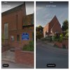
It's on a different side of Hamstead Road Lyn. Maybe Pedro's map was an original/earlier chapel, then it was re-built on the other side of Hamstead Rd/Newton Rd ?
This is the (later ?) chapel on the other side of Hamstead Rd. Still there according to Streetview. Viv.
This is the (later ?) chapel on the other side of Hamstead Rd. Still there according to Streetview. Viv.
Attachments
The Bishop's mother turned to Methodism after the death of her daughter (the Bishop's sister) She held prayer meetings in the cottage. This is allegedly the room used. Viv.
The chapel was originally built on the opposite side of Hamstead Rd https://greatbarr.wordpress.com/amenities/churches/newton-united-reform-church/
Viv.
Viv.
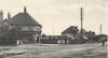
Trying to build up a picture of the 'hamlet' around Newton. The Malt Shovel further along the Newton Road and next to the Bishop's cottage once looked like this. It seems to have had a brewery alongside - Darby's. (Not surprising as there was a small stream at the rear). This seems to have been set further back off the early Newton Road (red dot). I wonder if this is the brewery which owned the Bishop's cottage terrace.

Just beyond this point there was a more acute turn in the road and on the opposite side there was another pub "The New Inns" later "The Newton". A replacement is still there on the corner of Bowstoke Road.
Before changes to Newton Road, the Bishops terrace of cottages reached halfway across the later and wider Newton Road footprint. I can start to see how this and the pubs would have amounted to a hamlet. And would "our" cottage sit somewhere in amongst all this ? We also have to remember that the road changes at this point would have dramatically transformed this part of Newton Road, making visualising all this quite difficult.
I'm also now wondering what the building was to the right of the 'L' shaped Bishops cottage terrace ? This too would have spread onto the later, wider Newton Road footprint. Viv.
PS Incidentally I think this part of Great Barr was at one time regarded as Perry Barr. Viv
Last edited:
Pedrocut
Master Barmmie
I can’t find a mention of Newton being associated with Great Barr from say 1800 to 1850. Here is a description of Great Barr from Parson’s in 1818. It doesn’t look to have been part of Perry Barr, being a place of great “antiquity.”


Trying to build up a picture of the 'hamlet' around Newton. The Malt Shovel further along the Newton Road and next to the Bishop's cottage once looked like this. It seems to have had a brewery alongside - Darby's. (Not surprising as there was a small stream at the rear). This seems to have been set further back off the early Newton Road (red dot). I wonder if this is the brewery which owned the Bishop's cottage terrace.
View attachment 121643
View attachment 121642
At this time there was a more acute turn in the road (green dot, there was also a pub at this point "The New Inns" later "The Newton"). Is the Newton pub still there ?
Before changes to Newton Road, the Bishops cottage(s) reached across half of the later Newton Road footprint. I can start to see how this and the pubs would have amounted to a hamlet. And would "our" cottage sit somewhere in amongst all this ? We also have to remember that the road changes at this point would have dramatically transformed this part of Newton Road, making visualising all this quite difficult.
I'm also now wondering what the building was to the right of the 'L' shaped Bishops cottage terrace ? This too would have spread onto the later, wider Newton Road footprint. Viv.
PS Incidentally I think this part of Great Barr was at one time regarded as Perry Barr. Viv

Eric Gibson
Gone but not forgotten
Does any of that still exist Pedro? The chapel with its painted windows etc.
Think it might be a reference to St Margaret's Eric. https://www.geograph.org.uk/photo/3210509 Viv.
Malt Shovel sounds a bit rough - or maybe a dodgy landlord Pedro.
This is how I visualise the cottage buildings in relation to the Newton Road - apologies, a bit niaive ! Viv.

This is how I visualise the cottage buildings in relation to the Newton Road - apologies, a bit niaive ! Viv.
Eric Gibson
Gone but not forgotten
could have used a landlord like that down here over the holiday. 
https://www.gloucestershirelive.co....nt-whitemead-closed-975436?service=responsive
https://www.gloucestershirelive.co....nt-whitemead-closed-975436?service=responsive
oldMohawk
gone but not forgotten
Looking again at the photo it has what most street pics usually have, a house (cottage), some people, a road surface, footpath, but most significant and unusual (to me) are the 40 bare copper wires supported by substantial telephone poles with ceramic insulators passing just above the bedroom windows. I have looked through many of the forum's street pics on the north side of the city and can find only one route which has such poles. In central areas and on other routes they used more expensive underground insulated cables. The cross-city and suburban roads did not seem to have such large poles and looking at pics of the Newton Rd/Queslett Rd there were only small 3 or 4 bar poles. These days they insulate single property wires and don't need ceramic insulators.
The only route I've found, so far, which has large poles with bars is the Aldridge Rd/College Rd/Kingstanding Rd/Chester Rd.
Aldridge Rd c1928 the closest location near the city centre ... they seem to have gone underground in Perry Barr.

Kingstanding Rd c1927

Kingstanding Rd c1943

Chester Rd (A452) leading to the A5 and on to the north west.

Irish Harp.

These large telephone poles disappeared by c1950, they must have been expensive to maintain. They were mainly used as trunk connections between city exchanges. Long distance trunk calls had to be made via the telephone operators before STD.
These large poles were quite rare but can other members possibly find pics of other routes with similar poles having 10 or more bars. The other problem is that the ones in the cottage pics have 10 bars (40 wires) whereas the ones in the above pic have 14 bars (56 wires) so not the same route. If '10 bar' poles can be found we might be able to follow it to the mystery cottage.
The only route I've found, so far, which has large poles with bars is the Aldridge Rd/College Rd/Kingstanding Rd/Chester Rd.
Aldridge Rd c1928 the closest location near the city centre ... they seem to have gone underground in Perry Barr.
Kingstanding Rd c1927
Kingstanding Rd c1943
Chester Rd (A452) leading to the A5 and on to the north west.
Irish Harp.
These large telephone poles disappeared by c1950, they must have been expensive to maintain. They were mainly used as trunk connections between city exchanges. Long distance trunk calls had to be made via the telephone operators before STD.
These large poles were quite rare but can other members possibly find pics of other routes with similar poles having 10 or more bars. The other problem is that the ones in the cottage pics have 10 bars (40 wires) whereas the ones in the above pic have 14 bars (56 wires) so not the same route. If '10 bar' poles can be found we might be able to follow it to the mystery cottage.

Radiorails
master brummie
So no one thinks extra arms could have been added to the ten as I suggested in my post 52? Because if that were the case then the 12 or more routes might be worth considering.
hi alan i completely missed that post of yours wish i hadnt because to be honest from early on i did think to myself just because there were 10 bars showing in the early photo could more have been added....if you say that extra bars could have been added or indeed taken away then it could throw a different light on the mystery..
lyn
wish i hadnt because to be honest from early on i did think to myself just because there were 10 bars showing in the early photo could more have been added....if you say that extra bars could have been added or indeed taken away then it could throw a different light on the mystery..lyn
Radiorails
master brummie
Only a supposition Lyn, but all seems worth a try. 
oldMohawk
gone but not forgotten
It is on the corner of either Little Hardwick Rd or Foley Rd. The building is still there but much changed and I can't at the moment determine which corner ... red spots.This one s labelled inter-war, Chester Road (Little Aston - where's that ?!) near Sutton Coldfield. A very tall pole. Mabe a bit too far away but interesting. Viv.

Only a supposition Lyn, but all seems worth a try.
supposition is all we have at the min alan so any ideas could prove useful
lyn
oldMohawk
gone but not forgotten
Just to make clear, I’m not suggesting the Cottage is Chester Rd area. I only showed it as the only route out of Birmingham I can find with such large poles. I’m hoping we can find another. I’ve studied the route on maps and can’t find suitable layouts.
Last edited:
Re map in #81. That's closer than I thought Phil. Thanks.
When (if) we pin down the location I shall move all the Bishop's Cottage discussion to a separate thread if it turns out to be a different location. Been interesting exploring all of this especially as it's an area that was on the cusp of major change. The telegraph poles alone echo that, turning the area from agricultural to rural in only a matter of years after the image shown us in Phil's original photo.
I'd also like to pursue a bit more the Bishop's cottage area. It can take us back quite a long way. Viv.
Edit. Thread now set up here https://birminghamhistory.co.uk/forum/index.php?threads/asbury-cottage-newton.48459/#post-608628
Curly
master brummie
It is on the corner of either Little Hardwick Rd or Foley Rd. The building is still there but much changed and I can't at the moment determine which corner ... red spots.
View attachment 121665
I disagree! Check here https://goo.gl/maps/u63dZqRagx32 - Junction of A452 Chester Road and Little Aston Road
Do we have a definition of "Great Barr" in the early 1900s ? Viv.
Eric Gibson
Gone but not forgotten
Little Aston and Great Barr maps. Could the road in the original picture of this quiz be Birmingham Road as shown on the Great Barr map?


Apparently the Parish of Aldridge included Great Barr (well in 1833 according to the site link below). https://www.historywebsite.co.uk/articles/Aldridge/19thcentury.htm
Viv.
Viv.