-
Welcome to this forum . We are a worldwide group with a common interest in Birmingham and its history. While here, please follow a few simple rules. We ask that you respect other members, thank those who have helped you and please keep your contributions on-topic with the thread.
We do hope you enjoy your visit. BHF Admin Team
You are using an out of date browser. It may not display this or other websites correctly.
You should upgrade or use an alternative browser.
You should upgrade or use an alternative browser.
Grand Union and Olton Mere
- Thread starter Frank M
- Start date
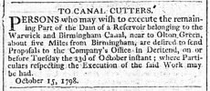
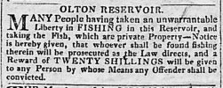
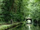
Well, that’s coincident. I was driving past yesterday and noticed Olton Reservoir on my navigator map and wonder why it was there. I intended to look it up today. Thank you.Olton Mere was created in 1799 as a reservoir to feed the Grand Union Canal. It is situated on the border of Solihull and Birmingham.
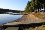
The Mere has suffered from the drought. I took this photo on Saturday. It took me 40 minutes to walk round it and only saw one heron and very few other birds.
View attachment 173143
I think it's just a reservoir known as Olton Mere.When did Olton Reservoir become Olton Mere ?
They must have had a hard winter that year.The 1903 mention advises that the ice is suitable for Skating (Februar)
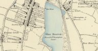
Interestingly, the 1886 map shows the reservoir labelled Olton Reservoir, but a small community of houses to the west are labeled Mereside. The only remnant of that community is a new road called Mereside Way
View attachment 173146
Stapes
proper brummie kid
Dovehouse Farm is a stunning Grade 2 listed building and well maintained, it's about 300m down from the A41 Warwick Road where the Dovehouse Parade shops are located.Thanks Mike. Great map. Interesting to note Dovehouse Farm in the bottom right of the map which is now Dovehouse Parade.
Stapes
proper brummie kid
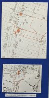
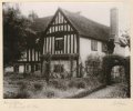
Lower map showing Mereside, one of the first houses to be built in St. Bernards Road, facing south it had vast grounds down to what became West Wawickshire (sports) Club ground. Top map around mid 1940's, marked up are 3 grand houses that all backed onto Olton Mere, that were demolished in the 1960's and repaced by several flats of it's era. These were part of my Local History Exhibition held annually in October at Olton Library, showing boards 4 of 8.
Attachments
Last edited:
Pedrocut
Master Barmmie
Stapes
proper brummie kid
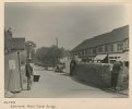
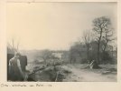
Good to see the old fashioned street lamp, also middle photo shows a tall mast, guessing it may be something to do with the sewers, as it's known that the canal was drained so pipework could be installed across the old bridge in 1904.Nice picture from 1937 of Richmond Road Canal Bridge, Olton, Warwickshire.
“View from top of bridge showing local people and children on canal bridge looking towards local shops.”
(Birmingham Archives and Collections)
View attachment 201783
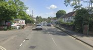
Google street view.
View attachment 201785
Stapes
proper brummie kid
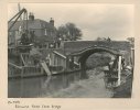
The corner house on Olton Wharf was origonally built (facing the canel) for the Coal Merchants clerk, and profession on the 1901 & 1911 census's list as coal carter. Note the house was built about half way across where the existing wharf road is today.This picture may have been taken at the same time as the one above…
Richmond Road Canal Bridge, Olton, Warwickshire. (Photographer in 1937)
“View from canal towpath showing workmen at work below bridge and local people looking over bridge.”
(Birmingham Archives and Collections)
View attachment 201789
A Sparks
master brummie
Might be what is known as a stink pipe?Good to see the old fashioned street lamp, also middle photo shows a tall mast, guessing it may be something to do with the sewers, as it's known that the canal was drained so pipework could be installed across the old bridge in 1901904
There are the remains of a couple in the area of London I live in now.
Stapes
proper brummie kid
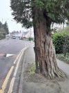
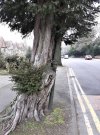
I think the London stink pipes are usually standalone street furniture with decorated painted crowns on top, whereas here in Olton there was a short one to the east of St Margarets church on the pavement, and 2 others were tethered to trees, one to an oak tree at the junction of Richmond Rd and Lyndon Rd on a 1904 photo by Barnett Johnstone, and the other still exists and is on Kineton Green Rd. immediatly before turning right into Brook Ln. [see photo] this green painted cast-iron pipe is secured by brackets (similar to roof guttering drain pipes) to a Yew tree.Might be what is known as a stink pipe?
There are the remains of a couple in the area of London I live in now.
Attachments
Lloyd
master brummie
Yes stink or stench pipes are for sewer ventelation, either to let gases out or air in to prevent syphoning. They are tall to distance the smell from pedestrians, and also to allow for floods not to spill out from them.Might be what is known as a stink pipe?
There are the remains of a couple in the area of London I live in now.
Some even have gas lamps to burn off flamable gasas - there used to be a number along the old Derby - Belper main road, many years back, alight 24/7.

