• Welcome to this forum . We are a worldwide group with a common interest in Birmingham and its history. While here, please follow a few simple rules. We ask that you respect other members, thank those who have helped you and please keep your contributions on-topic with the thread.

    We do hope you enjoy your visit. BHF Admin Team

Ghost Building Argyle St And Wharton Street

Frothblower

Lubrication In Moderation
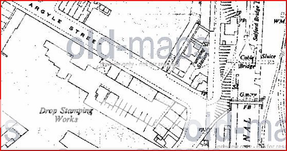
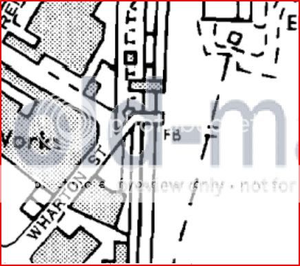
From the rear of where I work I can see this Ghost image of a long gone small building ( probably an out house) It is on the bend where Argle Street meets Wharton Street Nechells. It would cross the footpath leading onto the canal if it was still there. Anyone got any ideas of what it was.
If someone gets this I will be truly amazed
 
Could it have been a Mill of some kind, or a Railway station masters / signal man's house ... being so close to both the river Rea and Junction railway ? My old 1960 map shows the building was still there then and a little Terrace (but no name so could be Argyle or Wharton).
 
Last edited:
Could it have been a Mill of some kind, or a Railway station masters / signal man's house ... being so close to both the river Rea and Junction railway ? My old 1960 map shows the building was still there then and a little Terrace (but no name so could be Argyle or Wharton).

Thanks Pom. Love to see a print of that map:)
 
One of my maps shows a very short street just off the junction of Argile St and Wharton St called Park Mills Place, this is not shown on any of my other maps of the area Dont know date of map.
 
I have seen many buttresses shaped like that, it is possible at one time the wall could have could have been deeper. Is it deeper in the other side?

Phil
 
I would agree that it is too small to be a normal building. However the 1937 and 1962 maps show a bridge at about this point. Following Phil's suggestion, could it be smething to do with the support for this bridge. OS 1952-64 map section below.

Argylestcornerc1952-64.jpg
 
This may sound a bit daft but as it is at the top of a canal path could it have been some sort of housing for grit or salt or even straw to put down on the path in icy conditions. Dek
 
You could be right Dek but the path must have been moved a little because the image is right next to the path so this little building would have gone over the path.
This 1945 photo don't help much.
 
The whole wall at the back looks a bit mish mash with an extension on the end by the gate this I would say was existing.the wall at the front although built with old blue bricks looks to me to be new build (very clean and tidy)maybe this was extended as the gap looks pretty narrow to take horse and cart the transport of the day. Dek
 
I think a buttress was removed because it narrowed the gateway down to the canal. If you look closely to the left you will see where a new buttress was added in the same type of brick as the bridge.

Phil
 
I think Mike has this one right and if you look on his map you can see a footbridge crossing the canal and just next to it in dotted line is a structure carrying a pipe or such. I think that the outline of the old brickwork was probably a support for steps that would elevate pedestrian traffic to an initial level walkway that led to further steps at the footbridge. Perhaps under the walkway was a path that led to the tow path and maybe one or the other was gated. I cant tell for sure but the canal would be about 5 or 6 feet above the road level (the Rae passes under it) and the footbridge again would be maybe 15 or 20 feet above the canal so you would be looking at elevating traffic 20 or 25 feet maybe. Anyway the bridge is gone now so the opening next to the ghost outline only leads to the towpath. The dotted pipeway is still there though. The canal looks wonderful still.

If you look at the brickwork in the wall on the right side of the path leeding to the canal, you can see a lighter band of bricks that would have been protected from the elements by the steel beam structure of the walkway. The picture will need to be lightened by photoshop though. It shows up well if you do this.
 
I think you've hit the nail on the head Rupert. On my next lunch break I'll take some photos. See if I can confirm your theory
 
I would ask this question why would they have put a footbridge across at this point as there was nothing on the other side of the canal.Chris pity you never walked a little further,just past the pipes is a lock keepers house still lived in. Dek
 
I would ask this question why would they have put a footbridge across at this point as there was nothing on the other side of the canal.Chris pity you never walked a little further,just past the pipes is a lock keepers house still lived in. Dek

The house that is there now is quite modern about 1960/70 and nothing to do with the Canal.
It was a Toll gate not a lock.
There was something on the other side Dek, A great big power station.
 
Great photo's both.

I would have thought that there would have been a requirement for a bridge and walkway for workers at the power plant for people who lived in nechells or elsewhere for that matter. Trams would have travelled close to that point possibly and a hurried walk across the bridge might have got you to the time clockin before you lost pay. Anyway there was a bridge there and it can be seen on Mikejees map with the pipe bridge structure right next to it shown dotted. It's on the ground...look on the ground. There would have been outrigger supports for a walkway structure. They would have ended before the towpath and a transition platform would be where the stairs then led up to the bridge. The bridge has gone now but there may be some indications on the ground of concrete pillar bases. See mikes map. It shows the stairs and the run of the walkway.
One of Froths pictures looking towards the road from the path has some dark looking patches on the right in line...might be something. Might be post holes...don't tell time team.
 
Frothy's close up shows that the wall is all original brickwork and there's no sign that any bricks were tied in so it suggests a free standing structure in front of the existing wall, there is also no evidence of any flashing used to prevent water getting between the structure and the wall, indicating (to me anyway) that although it may have been there for many years it was not a permanent structure.

Colin
 
judging the hieght of the wall and imprint there in it would been a very small outhouse in deed ..it might of been an off shoot of a house sort of like an a small storage area like what youd find under stairwells or animal and stall say for chickens or pigs as people did keep animals in the town limits
 
As you say Rupert there was definitely a footbridge as shown on the map but I was disapointed not to see any signs of any brick or concrete footings for it on the canal, I must add it's all grown over so there maybe something within all that growth. I forgot to add, that building shape is about 9 foot tall.
 
There is certainly a pipe bridge at/ almost at the same place, but on the map there is a dotted line just above the bridge marked FB. I reckon thta dotted line is the pipe bridge. don't know what the letters on it mean. On the smaller scale map 1981-96 below the FB is marked (I don't think the pipe bridge would be marked on a map of this scale ), and there definitely seems to be a bit of road/ path leading up to the bridge.

argylest1981-96.jpg
 
F.B. does mean footbridge. This is stated in the O. S. map nomenclature. Hockley Brook meets the Tame at spaghetti junction around there and there used to be a branch off from the brook to around that point that is indicated on the 1890 OS. There is or was a pumping station there on the map which may have pumped excess water through the elevated pipe to the other side of the canal to release it into the old mill tailrace and thence to the Rea. Maybe this was a flood measure. As a matter of interest; where did the tram service come to in that area.
It looks like Colin is right and the structure would have been self standing. The wall seems to be part of the adjacent premisses. Maybe the ghost outline was part of formed concrete or brick steps that elevated traffic to a steel walkway structure with maybe wooden floor boards. Anyway nine feet seems about right with more risers further along the structure and the ghost outline slope seems to be about 9 1/2'" in 10" at the return at the top which would have been right for steps if that is what they were.
 
Back
Top