-
Welcome to this forum . We are a worldwide group with a common interest in Birmingham and its history. While here, please follow a few simple rules. We ask that you respect other members, thank those who have helped you and please keep your contributions on-topic with the thread.
We do hope you enjoy your visit. BHF Admin Team
You are using an out of date browser. It may not display this or other websites correctly.
You should upgrade or use an alternative browser.
You should upgrade or use an alternative browser.
City Centre Photographs
- Thread starter bobsummers
- Start date

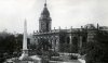
Two lovely photos Stitcher and Oldmohawk. Stitcher's photo gives an unusual view of the Market Hal, to the right and Burton's Tailors to the left. I like Oldmohawk's photo because it makes St Phillip's look like it had a mini boulevard! Anyone know what the row of stone features are near to the boy? Viv.
Bernard67Arnold
master brummie
Mine was fifty years later, Bernard.jpg")
S
Stitcher
Guest
really do like all the pics of St. Phillips because they always have an air of peace and tranquility.
S
Stitcher
Guest
 1948.
1948.Bull Street & Martineau Street.
oldMohawk
gone but not forgotten
Hi Viv,Anyone know what the row of stone features are near to the boy? Viv.
I wondered about those stone features but have no idea about their purpose. Here is another photo of Temple Row same year. I like this photo because on the corner of Cherry Street I can see the Model Aerodrome shop from where I bought my balsa wood and kits for model aeroplanes - brings back a few memories.
oldmohawk

Phil
Gone, but not forgotten.
Phil
Gone, but not forgotten.
Concerning my last post, here is a better photo of the fencing with it's upright supports fixed to the stonework blocks. I think the fencing was removed during the war and I suppose it was never replaced.
Attachments
Hi OldMohawk,
the picture of Temple Row brought back memories for me, too. I used to hang around the Model Aerodrome most Saturdays and the occasional afternoon during the school holidays. Model flying is in my blood, and I'm off flying this afternoon, the third time this week! Great being retired!
G
the picture of Temple Row brought back memories for me, too. I used to hang around the Model Aerodrome most Saturdays and the occasional afternoon during the school holidays. Model flying is in my blood, and I'm off flying this afternoon, the third time this week! Great being retired!
G
S
Stitcher
Guest
 1965.
1965.colmore Circus almost completed.
guilbert53
master brummie
A few people have said they like my "before and after" photos.
Here are a couple more.
Looking over the canal from Sheepcote St in the late 1980s (they have already started building the ICC)

Same view today (2010)

Here are a couple more.
Looking over the canal from Sheepcote St in the late 1980s (they have already started building the ICC)
Same view today (2010)
oldMohawk
gone but not forgotten
It's quarter to four the scene seems peaceful in the afternoon sun. The parking looks easy with so few cars in the postwar 1940's and a nice spare wheel on the car in view. All structures in the photo are stone except for the square brick-built block on the pavement, although they darkened the corner bricks for some decoration maybe....

B
BernardR
Guest
True but some are poorly identified Carolina and I failed to see how you could offer up corrections.
Bernard67Arnold
master brummie
you sound like Francis Albert, its a quarter to three, theres no one in the place except you and me, BernardIt's quarter to four the scene seems peaceful in the afternoon sun. The parking looks easy with so few cars in the postwar 1940's and a nice spare wheel on the car in view. All structures in the photo are stone except for the square brick-built block on the pavement, although they darkened the corner bricks for some decoration maybe....
View attachment 79716
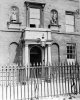
S
Stitcher
Guest
 1912.
1912.Easy Row/Edmund Street.
guilbert53
master brummie
Another before and after.
Taken in the mid 1980s looking towards Sheepcote Street and Five Ways with what will become Brindley Place on my left.

Taken in 2011

Taken in the mid 1980s looking towards Sheepcote Street and Five Ways with what will become Brindley Place on my left.
Taken in 2011
guilbert53
master brummie
Another "before and after" from Broad St. The first is from November 1986, the second from 2010.
Site of Brindley Place and Convention Centre on Broad Street. Look at that stunning brewery on the right.
Amazing to think that was still in the centre of Birmingham, on Broad St, in the mid 1980s.
Not a soul about in the first picture, on what was a sunny Sunday.

Same view in 2010.

Site of Brindley Place and Convention Centre on Broad Street. Look at that stunning brewery on the right.
Amazing to think that was still in the centre of Birmingham, on Broad St, in the mid 1980s.
Not a soul about in the first picture, on what was a sunny Sunday.
Same view in 2010.


True but some are poorly identified Carolina and I failed to see how you could offer up corrections.
Bernie someone has just forwarded the Birmingham info which was put on FR - and there was an email address [email protected] IF... you wanted to set the records straight. Carol
cookie273uk
Gone but not forgotten
Guilbert53 post 966, see they can restore buildings if they put their mind to it. The only brewery I knew in the city centre was Davenports "Beer ar home" brewery, although Holts brewery was fairly close to the city centre (by the main fire station) I cannot place that one in Broad St, what brewery was that ??? Eric
guilbert53
master brummie
Guilbert53 post 966, see they can restore buildings if they put their mind to it. The only brewery I knew in the city centre was Davenports "Beer ar home" brewery, although Holts brewery was fairly close to the city centre (by the main fire station) I cannot place that one in Broad St, what brewery was that ??? Eric
Amazing thing is that when I took that picture in the mid 1980s I was no great fan of buildings and to be honest did not even notice that brewery, it was only in the picture by "accident". I certainly took no other pictures of it.
It was only when I dug out those pictures a couple of years ago (when I had more interest in buildings) that I really noticed it in the picture and though "look at that".
How I wish I had to taken more pictures of it at the time... you dont know what you've got till ts gone.
It was behind the Crown Inn on Broad St. I know little about it but a search on the web indicates it was Butler's Crown Brewery.
Then it became Mitchell and Butlers before moving to Cape Hill.
You can read a little about it here (see text at top)
https://www.midlandspubs.co.uk/breweries/mitchellsandbutlers/history.htm
There is a topic for the Crown Inn on BHS here
https://birminghamhistory.co.uk/forum/showthread.php?t=26143
cookie273uk
Gone but not forgotten
Caroina and Guilbert, thanks for info. Eric