-
Welcome to this forum . We are a worldwide group with a common interest in Birmingham and its history. While here, please follow a few simple rules. We ask that you respect other members, thank those who have helped you and please keep your contributions on-topic with the thread.
We do hope you enjoy your visit. BHF Admin Team
You are using an out of date browser. It may not display this or other websites correctly.
You should upgrade or use an alternative browser.
You should upgrade or use an alternative browser.
Church Road, Yardley.
- Thread starter ALB10N
- Start date
I was delighted to see the 1973 photograph which had been posted by Phil. I had not spotted that before. Sue Mallings correctly points out that this terrace (which is close to Wroxton road) has been discussed elsewhere on this web site but I will make some observations here for clarification.
On the left of the photo is of course, Mr Dawkin's newsagent which is still trades as a paper shop.
Next you have a double fronted house. This was originally two houses. The left hand side was occupied by a charming widow called Mrs Green who died in the 1960s. The next one had been occupied by my ancestors on and off since it was built round about the turn of the last century. It was my parent's first married home and my home for my first 3 years. After we moved to next door in the 1950s it was occupied by the Unett (unsure of the spelling) family for some years. It changed hands, then was bought by someone who converted the two properties.
The next shop number 206 was originally built as a house (as all three shops in this row were) and converted, I guess in the early 1920s. The premises was occupied by four generations of my family from the day it was built until 1980. It was primarily a hardware and 'fancy goods' originally established by my grandmother then run by my father Alfred Holloway. It was never occupied by Mr Glyn Vaughn. He was actually hoping to take it over after my father died in 1979 but died suddenly very soon after.
So, next to 206 we have Mr Vaughn's barber shop. He and his wife (Nancy I think who died young in the 1950s) and their daughter Carol (who was a childhood friend of mine but we sadly lost touch ) originally lived there then later moved out, I think to a house in Small Heath, but he kept the shop premises. I believe they also owned a house or farm in Wales. He always had a sheep dog with him. His original side line was keeping hens in the back garden, then later he moved on to dealing in antiques. He also had a shop premises in Small Heath (Green lane I think) for the antiques but that looked more of a storage facility.
Carol became a dress fabric buyer for Rackhams and also served them in the store (far left hand side at the back). She had wonderful taste. She later left there and went into business with her father but she specialised in antique jewellery which was displayed in the former barber's shop window. The front entrances to the two shops in the photo were never angled and quite separate.
The third shop in the row, out of the photo, was Mr Edmund's greengrocer shop.
The caption to this photograph of the house called The Croft still appears to be valid. It does still stand although it is surrounded by other properties now. I found it on Google maps Streetview. This is the link:

Google Maps
Find local businesses, view maps and get driving directions in Google Maps.www.google.co.uk
Here is a photograph of Croft road under construction in 1930. The road is as yet unmade.
View attachment 136416
I’m certain this is the view from the Barrows Lane side? Looks grand.
Has anyone got any photos of the other end of Croft road, from the church road side? The road bends round the side. I’ve always been curious, the last few houses on the road were built in the late 70s from what i know. Yet all the other houses on the road are 30s/40s built.
I have seen old maps of Croft road and show that the houses towards the end of the road on the bend only came up considerably later. The area is marked out as another building but not sure what. What was there before the 4 houses were built ?
Thanks in advance
Attachments
ItalianNonna
proper brummie kid
I remember Ivy Henn had a sweet shop which is now a house in Wroxton Road same side as Kelly's bathroom shop going up toward Croft Road.
suemalings
master brummie
Not got any photos but I know exactly which houses you are thinking about. I have asked mother in law who lives in Newcroft. I think they may have been build very early in the 1970's but I have always known them to be there! The house in Church Road on the corner used to belong to a plumber (I think) Can't remember exactly but he used to work in the garage/shed that is in Church Road. I'll see what I can find out. MIL moved into Newcroft in about 1958 and previously lived in Church Road so has been a wealth of info about Yardley.
Thank you - yes it’s the 4 houses built in the 70s at some point. I posted photos of the aerial maps which shows the area blocked out but not sure by what. All the other houses on Croft road built during the 1930s, and then later, these were seen on the 70s aerial map., with the space taken by the added 4 houses. Quite interesting to see how the area changed, but also a very large prominent plot which was filled by these 4 houses I can only assume had something substantial or of interest here before the houses were built.Not got any photos but I know exactly which houses you are thinking about. I have asked mother in law who lives in Newcroft. I think they may have been build very early in the 1970's but I have always known them to be there! The house in Church Road on the corner used to belong to a plumber (I think) Can't remember exactly but he used to work in the garage/shed that is in Church Road. I'll see what I can find out. MIL moved into Newcroft in about 1958 and previously lived in Church Road so has been a wealth of info about Yardley.
Can’t wait to find out any info/see photos if anyone has anything!
I’m sure that’s a house now. That’s the last on the row from the 30s/40s built houses. Then the 4 houses built in the 70s start. But from the older maps, looks like no 75 had a very large garden area so could have been. Not sure about the rest of the area though and what was there before the houses were builtIn 1950 no 75 is listed as a petrol filling station
In 1964 there was a request for an illuminated sign for 75A: Jones family. However later applications have 75A in the back garden of 160 Church Road and much smaller. So maybe Jones had a filling station with that number in the large building, later keeping that number for the smaller car repair/storage unit to the west of the wall/fence after the newer houses were built.I’m sure that’s a house now. That’s the last on the row from the 30s/40s built houses. Then the 4 houses built in the 70s start. But from the older maps, looks like no 75 had a very large garden area so could have been. Not sure about the rest of the area though and what was there before the houses were built
suemalings
master brummie
Sadly mother in law is in hospital at the moment. I live in Cambridge but cannot visit due to the fact that I am over 65 so due to infections I am not allowed into the ward!. However her niece and nephew are with her and text constantly. I have sent a letter (she is deaf too and cannot hear on the phone) so as soon as I know I will get back to you. As I said, she has lived in Yardley all her life, her dad owned the newsagents in Church Road and she lived above the shop until she married in the 1950's.
Dennis Williams
Gone but not forgotten
suemalings
master brummie
Can't quite see where that is. Where is Croft Road?
Yes this could be right, sounds logical enough. And with the garage that backs onto church road, by the first house on Croft road, the location of a filling station would be ideal for garage/motorists.In 1964 there was a request for an illuminated sign for 75A: Jones family. However later applications have 75A in the back garden of 160 Church Road and much smaller. So maybe Jones had a filling station with that number in the large building, later keeping that number for the smaller car repair/storage unit to the west of the wall/fence after the newer houses were built.
Not like we have much else to go by to be honest, or any photos of the lower end of Croft road - by the church road.
Thanks
oldbrit
OldBrit in Exile
This is where CROFT ROAD enters CHURCH RD from Google street view Hmmm IT says the image file is too large for the server. But Google Street view has it. Not sure how to downsize the image? but it does show some commercial buildings at the junction of Croft Road and Church Road. this is up from the Yew Tree on Church Road going towards the Church. I do remember this Croft Road is a long road that winds around to Barrows lane then I would go down Barrows Lane to Moat Lane and my house I could email the photo I think if you give me an Email Address
Last edited:
Dont know if anyone remembers but i had an uncle that used to live on Church Road and operated a garage at the back of the house where he used to repair cars as a business, there was a gap in between the terraced houses where he used to take the cars to the rear garage. This would be in the 50,s and 60,s the approx location is about where Tesco filling station is now.Read with interest your comments on Church Road, my grandfather lived at 218, he also owned a cycle shop in the early 1950's in the same road. His name was William Linforth. His wifes parents (surname - Horsley) lived in Church Terrace - opposite St Edburgha's Church, also in Church Road Yardley. Wonder if you or others have any information on these.
His name was George Edward Stenson, and before him his father also repaired cars in the same location his name was Charles Leonard Stenson.
Dont know if anyone remembers them, maybe you had your car repaired.
He lived at 53 Church Road if anyone remembers, George Edward was sadly killed in a car accident in Burntwood in 1968.
Last edited:
Dennis Williams
Gone but not forgotten
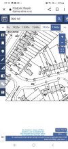
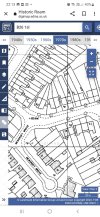
Two more files for the location showing a filling station in 1940 and a motor engineers in 1963Yes this could be right, sounds logical enough. And with the garage that backs onto church road, by the first house on Croft road, the location of a filling station would be ideal for garage/motorists.
Not like we have much else to go by to be honest, or any photos of the lower end of Croft road - by the church road.
Thanks
Attachments
oldbrit
OldBrit in Exile
Itried to post photos showing the end of Croft rd and Church Road it said they were too big?Yes this could be right, sounds logical enough. And with the garage that backs onto church road, by the first house on Croft road, the location of a filling station would be ideal for garage/motorists.
Not like we have much else to go by to be honest, or any photos of the lower end of Croft road - by the church road.
Thanks
pjmburns
master brummie
Instructions to reduce image size here
 birminghamhistory.co.uk
Uploading Pictures
I want to and have tried to upload a few newspaper cutting from 1968 & 1992 that will be of interest to you all but it just keeps telling me that they are too big and I don't know how to make them smaller, any help would be appreciated :))
HiItried to post photos showing the end of Croft rd and Church Road it said they were too big?
I have not seen these. Could you try uploading again, or maybe sending them to me and I could try?
Thank you
suemalings
master brummie
According to mother in law it was a two pump petrol station at the end of Croft Road.


Does this web site show the photos of the petrol station you are thinking about?

 outercirclebus.com
THEN & NOW on the Outer Circle – stage 13
Having gone around the Tesco car park at the Swan, we join the dual carriageway that takes us to The Yew Tree – the original “commercial centre” in Yardley. There was at one time a yew tree standin…
outercirclebus.com
devonjim
master brummie
The garage in this web is on Stoney Lane just beyond "The Yew Tree!Does this web site show the photos of the petrol station you are thinking about?
THEN & NOW on the Outer Circle – stage 13
Having gone around the Tesco car park at the Swan, we join the dual carriageway that takes us to The Yew Tree – the original “commercial centre” in Yardley. There was at one time a yew tree standin…
According to Google Maps Streetview, 2022 the former petrol station is now called Grayson's Inn. I must say, seeing a photo of the building in its original form it did look rather charming. How easy it is to destroy the character of a building by removing the original features like window frames and chimneys.The garage in this web is on Stoney Lane just beyond "The Yew Tree!
Incidentally, to the left of it is a commercial building which used to be the Birmingham Co-operative Society which was the main large grocer in the area when I was a child. It seemed vast to me as an infant. You can still see the BCS plaque still on the front. The upstairs of the latter, Sue Malling told us, was used as a dance hall years ago and it was where the late Queen's coronation evening party was held in 1953, mostly for local adults. The Co-op would also use the room for promotional demonstrations and films. As a child, I was taken to see a film about a factory canning food, and another time, a demo of making a cake from a cake mix.
The main shop below was originally formal counters (maybe white marble) where, say, cheese would be cut by the assistant. For hygiene, a cashier would be in some sort of booth high up in the shop against the right hand wall, near the ceiling. The customer would put their money into a metal container and it would fly up to the booth via a pully contraption of some sort where the cashier would process the purchase and return any change. A dividend (or "divi") would also be applied, a bit like a loyalty card today.
Just to add a bit more fact Edward Stenson was married to a lady called Barbara and Len Stenson was married to Florence always known as Floss they all lived at 53 Church Road and Barbara had twins and named them Leon and Lester, just thought it might jog someones memory. Before moving to Church Road Len and Floss used to live at 96 Cranes Park Road.Dont know if anyone remembers but i had an uncle that used to live on Church Road and operated a garage at the back of the house where he used to repair cars as a business, there was a gap in between the terraced houses where he used to take the cars to the rear garage. This would be in the 50,s and 60,s the approx location is about where Tesco filling station is now.
His name was George Edward Stenson, and before him his father also repaired cars in the same location his name was Charles Leonard Stenson.
Dont know if anyone remembers them, maybe you had your car repaired.
He lived at 53 Church Road if anyone remembers, George Edward was sadly killed in a car accident in Burntwood in 1968.