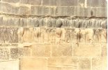
• Welcome to this forum . We are a worldwide group with a common interest in Birmingham and its history. While here, please follow a few simple rules. We ask that you respect other members, thank those who have helped you and please keep your contributions on-topic with the thread.

    We do hope you enjoy your visit. BHF Admin Team

Church Road, Yardley.

Agree with that . Going back down Church Road from the Swan island that row of shops in the 1970s i am sure Blue Circle Taxis were based there. A bit further down on the right was a model shop before Harvey Road.
Yes it was a taxi place used to use it when we came out of Bloomers nightclub
in the 80/90s it was a second hand toolshop called Toolman
run by Terry who lived a few doors up from me on Preston Rd
 
Another of Church Road. Couldn't work out whereabouts this was. An important junction I suspect.
View attachment 203329
Junction of Coventry Rd and Church Rd. B'ham left, Coventry right. Opposite towards what I always knew as the Yew Tree Pictures #3,5,7 on the left of this road. Also In 1968 a small travel agent where I booked our Honeymoon flight!
 
Last edited:
Junction of Coventry Rd and Church Rd. B'ham left, Coventry right. Opposite towards what I always knew as the Yew Tree Pictures #3,5,7 on the left of this road. Also In 1968 a small travel agent where I booked our Honey Moon flight!
Billy Haden, the barber on the left across from the bakery, cut my hair up 1957 when I left for America
 
Agree with that . Going back down Church Road from the Swan island that row of shops in the 1970s i am sure Blue Circle Taxis were based there. A bit further down on the right was a model shop before Harvey Road.
There was also a Record shop on the right before Harvey Road in the early to mid 1970s, if memory serves next to Model shop.
 
Church Road in 1913. Most of the 1913 features are still there. A lovely spot. Memorials/vaults seem to have been removed from the churchyard alongside the church (well at least anything above ground).

It's difficult to get the present day view in the same position as there are two sets of bollards blocking access. However, I managed to get a view from the other direction. And as a bonus, I discovered what was once a farm (extreme right of the B&W photo). Any ideas of the farm name? Was it once a dairy farm, perhaps ? And is that a brick-built dog kennel next to the farm cottage ?

Screenshot_20250608_101951_Chrome.jpgScreenshot_20250608_122437_Maps.jpgScreenshot_20250608_122553_Maps.jpgScreenshot_20250608_122602_Maps.jpg
 
Last edited:
could it be church farm?

Church Farm: This farm is one of the few surviving original farm buildings in Yardley Village from before the early 19th century. The farm buildings associated with Church Farm are a notable survival, including a cow-house, barn (converted to a dwelling), the farmhouse (No 451), and a stable. The cowhouse was built around 1820, and the barn dates from 1848.
 
Church Road in 1913. Most of the 1913 features are still there. A lovely spot. Memorials/vaults seem to have been removed from the churchyard alongside the church (well at least anything above ground).

It's difficult to get the present day view in the same position as there are two sets of bollards blocking access. However, I managed to get a view from the other direction. And as a bonus, I discovered what was once a farm (extreme right of the B&W photo). Any ideas of the farm name? Was it once a dairy farm, perhaps ? And is that a brick-built dog kennel next to the farm cottage ?

View attachment 203429View attachment 203431View attachment 203433View attachment 203435
That looks like the entrance to H M TRIGG the blacksmith i remember that from the 1960s and 1970s . I also remember the Post Office opposite the church and there was a greengrocer also opposite the church i think it was Maycocks.
 
Back
Top