-
Welcome to this forum . We are a worldwide group with a common interest in Birmingham and its history. While here, please follow a few simple rules. We ask that you respect other members, thank those who have helped you and please keep your contributions on-topic with the thread.
We do hope you enjoy your visit. BHF Admin Team
You are using an out of date browser. It may not display this or other websites correctly.
You should upgrade or use an alternative browser.
You should upgrade or use an alternative browser.
Richard Dye
master brummie
I grew up riding my bike around them and canoeing in a canvas kayak, watched a lot of canal journeys on tv, cruising the cut, great canal journeys etc. I never stop marveling at the wonderful engineering and workmanship involved. It will be a long time before we so much beauty and innovation again. Thank goodness for what we have!
I have to say that the Lichfield and Heatherton Caal Restoration Group are superb. A very professional group of volunteers who are making remarkable progress. We will end up with a seven mile long linier park that is multi use and diverse in terms of the natural environment. We need more of these worthwhile community projects
Richard Dye
master brummie
Pedro, do you happen to know what year the boat was built?An unusual and interesting narrow boat.
I have several generations of my family who lived and worked on the canals their family name was Flavel, I would love to find out if they worked for someone or owned their own boat.The story I was told was that my Great Grandfather Major Flavel lost an eye when he was kicked by a horse he was leading along the tow path he ended up living opposite the canal in Lifford Lane along with my grandparents.Not much on the forum about the canals which played a big part in out lives
Any Questions you have on the canals of Birmingham we will try to answer
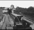
Here is a photo of a canal boatman touching up the paintwork on his barge in 1947
Bottom pic shows the old barge horse earning his living by pulling the barges along the cut (Canal) at a leisurely pace
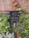
I walked along the Birmingham Main Line to The Roundhouse for the first time yesterday and passed Albert Rooke's memorial garden which is attractively planted out. 'The last Harbour Master of Birmingham.

More about Albert Rooke here. https://canalrivertrust.org.uk/abou...ds/wild-in-birmingham/alberts-memorial-garden

More about Albert Rooke here. https://canalrivertrust.org.uk/abou...ds/wild-in-birmingham/alberts-memorial-garden
Richard Dye
master brummie
Welcome to The Forum Skybus! There is a lot on here about canals as I am sure you have seen. I can’t personally help you but there are some pretty talented folks on here with lots of knowledge and insight!I have several generations of my family who lived and worked on the canals their family name was Flavel, I would love to find out if they worked for someone or owned their own boat.The story I was told was that my Great Grandfather Major Flavel lost an eye when he was kicked by a horse he was leading along the tow path he ended up living opposite the canal in Lifford Lane along with my grandparents.
Janet Hunt
master brummie
This booklet may help with your searchI have several generations of my family who lived and worked on the canals their family name was Flavel, I would love to find out if they worked for someone or owned their own boat.The story I was told was that my Great Grandfather Major Flavel lost an eye when he was kicked by a horse he was leading along the tow path he ended up living opposite the canal in Lifford Lane along with my grandparents.
Richard Dye
master brummie
Janet, excellent piece of history!This booklet may help with your search
Richard Dye
master brummie
Welcome to The Forum alanluiz! There are great folks on this, enjoy!very nice
DavidGrain
master brummie
All this work costs money and is included in the cost we hear of HS2. No credit is ever given for these non railway benefits to the environment.
DavidGrain
master brummie
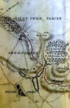
Map of the Dudley No. 2 Canal as it passes through the Parish of Hales Owen in Shropshire c 1792.
No, I haven't got that wrong. That was the way Halesowen was spelt back then and it was an exclave of Shropshire not becoming Worcestershire until 1844. For orientation purposes, the road running from Bells Wood, top Centre, to Hales Owen, bottom left, is the current Mucklow Hill.
Photo from the David Morris collection, previously posted on the Oldbury and Black Country History page on Facebook.

Richard Dye
master brummie
Great piece of history David!Map of the Dudley No. 2 Canal as it passes through the Parish of Hales Owen in Shropshire c 1792.
No, I haven't got that wrong. That was the way Halesowen was spelt back then and it was an exclave of Shropshire not becoming Worcestershire until 1844. For orientation purposes, the road running from Bells Wood, top Centre, to Hales Owen, bottom left, is the current Mucklow Hill.
Photo from the David Morris collection, previously posted on the Oldbury and Black Country History page on Facebook.
View attachment 186214
Janet Hunt
master brummie
If you have the energy you can follow the old route of the canal using this site.

 walkmidlands.co.uk

The Lost Lapal Canal walk
A varried suburban and rural walk between Selly Oak in Birmingham and Halesowen in the Black Country along the route of the long closed Lapal Canal. Including the site of the ill-fated Lapal Canal Tunnel and the sites of the ruined Weoley Manor and Halesowen Abbey.
 walkmidlands.co.uk
Richard Dye
master brummie
Great find Janet!If you have the energy you can follow the old route of the canal using this site.

The Lost Lapal Canal walk
A varried suburban and rural walk between Selly Oak in Birmingham and Halesowen in the Black Country along the route of the long closed Lapal Canal. Including the site of the ill-fated Lapal Canal Tunnel and the sites of the ruined Weoley Manor and Halesowen Abbey.walkmidlands.co.uk
Janet Hunt
master brummie
I remember this old un-used canal bed it was at the back of my Aunt's house. We used to play in that area a lot, back in the day. I can even remember the journey to my Aunt's we used to get off the bus at the Old bus station and cut through Selly Oak Park to get to her house, used to love kicking up all the fallen leaves in the Autumn. Still love doing that now!Great find Janet!
oh i would love to do it janet...trouble is although my head tells me i can my knees just would not cope with that distance unless of course i could use my mobility scooter and looking at some of the lovely photos a scooter would not be practical...Great find Janet!
lyn
DavidGrain
master brummie
I may have mentioned this in the past but some years ago I led a walk for the Black Country Society along the Dudley No.2 Canal on the parts that are in Birmingham. We started in the California area in Stonehouse Lane. There is a grassed area there which I see from the map is called Old Quarry Park which is obviously a landfill as there are gas vents around the park. On the old maps, it shows a brickworks at this point and I think it is the site of the eastern end of the Lapal Tunnel. We then walked down Somery Road and picked up traces of the canal at the back of Weoley Castle. We followed the course of the canal all the way to Selly Oak Park. The Retail Park had not been built at that time and I don't think we could have got through to the Worcester and Birmingham Canal. We walked down Harborne Park Road to just before the Shell filling station and then picked up a path which led us back along the Bourn Brook to California Way and back to our starting point. When we did the walk the path was not too clearly marked but I see that Google Maps shows the path as Bourn Brook Walkway which suggests it has been cleared.
Malvernian
master brummie
You can re-live the walk with the aid of the beautiful NLS Maps website - https://maps.nls.uk/geo/explore/#zoom=18.0&lat=52.44439&lon=-1.97682&layers=168&b=3 - hope that works - slide the blue button around. The tunnel mouth is at the SW corner of the brickworks and most of the canal line is intact. The final lock before the canal joined the W&B canal is under the supermarket car park and the final wharf is under the supermarket building. The new line for the canal is squeezed in to the south of the supermarket building.I may have mentioned this in the past but some years ago I led a walk for the Black Country Society along the Dudley No.2 Canal on the parts that are in Birmingham. We started in the California area in Stonehouse Lane. There is a grassed area there which I see from the map is called Old Quarry Park which is obviously a landfill as there are gas vents around the park. On the old maps, it shows a brickworks at this point and I think it is the site of the eastern end of the Lapal Tunnel. We then walked down Somery Road and picked up traces of the canal at the back of Weoley Castle. We followed the course of the canal all the way to Selly Oak Park. The Retail Park had not been built at that time and I don't think we could have got through to the Worcester and Birmingham Canal. We walked down Harborne Park Road to just before the Shell filling station and then picked up a path which led us back along the Bourn Brook to California Way and back to our starting point. When we did the walk the path was not too clearly marked but I see that Google Maps shows the path as Bourn Brook Walkway which suggests it has been cleared.
Couple of interesting photos in posts 29/30 on this page - https://birminghamhistory.co.uk/forum/index.php?threads/california-inn-northfield.7685/page-2
Last edited:

