• Welcome to this forum . We are a worldwide group with a common interest in Birmingham and its history. While here, please follow a few simple rules. We ask that you respect other members, thank those who have helped you and please keep your contributions on-topic with the thread.

    We do hope you enjoy your visit. BHF Admin Team

Canals of Birmingham

  • Thread starter Thread starter O.C.
  • Start date Start date
The Church was close to where my ancestors John and Thomas Gill had their home and Sword making premises. Demolished the year I was born - no link by the way.
 
a1.jpg-----a2.jpeg-----a3.jpeg
Because the church is mentioned along with the Broad Street canal I assume this will not be deemed off thread.
When the church was demolished the area became a car park.
 
hi mort and stich

on the last thread of the old gas street basin way back in thr fifties those to locks was ot there as you came of the bridge
from either side of the walk it was very dark and low it was dark you could not see your hand in front of yourself
the orinional setting of the bridge in stiches previuos pict was the only scene i seen and remember where all the coal barges and carriers was all moored to gether and the little tiny boat houses was all boarded up ;
i have not been down there in near forty to fifty years as kids we spent most of our days down and along there from on end of
the cut from th black country through to gs street and we came in on monument rd there used to be a gang of us kids
we would start at belliss and morgan and drop down on to there barges at there into slip bay and unleash a barge and push our selves into the grand union main stream and float down the cut towards gas street but some toimes we would only go to lakes scrap yard which was in ledsam street
and get out on sheepcote street at baxtors bolts factory and walk through that drk tunnel and it was very dark in there beleive me
mort i am waiting another month to july and if you are ready we can take that scenery view and nostagal for me or you if you was like
us on the cut ; we was never off it any way mort and stich thanks for the memory ; by the way mort i do not think the long boat was where you think it was it was more behind the big building behind the hall of memory [ baskerville house ] and king alfred place ;
speak to you soon guys astonian ;; alan;;;;
 
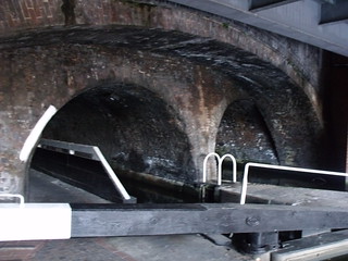
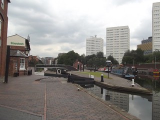
Astonian & Morturn, hello both, picture No.1 is said to be Farmers Bridge, just why it has that name I di not know. The second picture is from 1954 and is on the opposite side of the canal to the old Longboat pub site which was near to Camebridge Street. Farmers locks, as I understand it took the canal to a lower level somewhere near to Newhall Street.
 
Last edited by a moderator:
Hi stitch
many thanks for telling us about farmers bridge even thou we spent thousands of hours down the cut and more so gas street basin we never grew growing up thats what it was called ;
yes you are correct stitch its was directly behind baskervillehouse; well just yards from baskerville house
almost as well across from the baskervll was the old birmingham corporation carpark wher they ws in the fifties and thee rd sweepers ; and my old friends the newbury ran te king edward just across the rd from there and then they moved to the turf at spring hill and ten to the big pub in or should i say on victoria rd aston ; those was the good old days stitch when life was slower
best wishes to you and your good lady stich ; ]oh also my dear old friend mort astonian ;; alan ;
 
Re: Canals of Brum

That picture in the bottom left (with the house, and the path going off to the right) looks a lovely spot.

Do you remember where that was?
 
Re: Canals of Brum

Yes it's The Junction House on the Worcester & Birmingham just up from Wharf Lane bridge behind the park (King's Norton)- near the junction with the Stratford on Avon Canal. The other pictures show the SoA guillotine lock (I assume the bridge is Lifford Lane) and the portal of Brandwood Tunnel.
 
Re: Canals of Brum

Yes Speedy23, all correct, I see you are in Warstock, have you seen the cottage by Yardley Wood Rd, it's almost finished now & looks great, should be worth a tidy sum when completed!
 
Now live near Shipston-on-Stour but brought up on the Flint's end of Warstock Road - still visit family there......
 
How I remember the working barges and commercial traffic on the canal system as a boy, and watching them ply from the top deck of a BCC Bus.
paul
 
Thanks for tha info David, I knew it was somewhere near but did not knoe the exact location.
 
Hello again Paul, I remember fishinig with my dad in the canals, mainly Knowle and a few miles either way. The barges were up and down all the time and my dad said it was a good thing because they stirred the bottom up a bit and it got the fish feeding.
 
Great times fishing around Perry Barr locks and pint of maggots from Winfields shop at Tower hill, no fridge in those days so any left over maggots thrown to the fishes.
 
aa1.jpeg 1959.-----aa2.jpeg
These old geogian cottages are/were close to Falk's Warehouse and these tow photo's show them as they were and how they were renovated with a cobbled road/pathway leading to the Longboat.
 
Truly wonderful to see the restoration that has gone on Stitcher, it makes you wonder how many more old buildings could have survived had the will been there.
paul
 
Hello BordesleyExile, it is a fact that the canals were allowed to become an eyesore but a magnificent job in my opinion has improved them a million times over.
 
Astonian & Morturn, hello both, picture No.1 is said to be Farmers Bridge, just why it has that name I di not know. The second picture is from 1954 and is on the opposite side of the canal to the old Longboat pub site which was near to Camebridge Street. Farmers locks, as I understand it took the canal to a lower level somewhere near to Newhall Street.


The first photo is of Lock 9 underneath Newhall Street. The other photo is of Lock 1, the top lock, adjacent to Cambrian Wharf. The whole 13 lock flight is known as, and named after 'Farmer's Bridge', which was at or near the top lock, the start of the Birmingham Fazeley Canal. I don't have my cruising guides handy, but if there is a name plate on the bridge of the first photo, I'm sure it would read Newhall St Bridge. I understand that all bridges on this canal have names where many are simply numbered. The next bridge up, adjacent to the JobCentre, Summer Row, is Saturday Bridge. (That's another story! = Possibly named after the alleged practice of paying boatmens' wages at this point on Saturdays.)

The lower level down from Cambrian Wharf was to an area bounded by Lionel St, Newhall St and Gt Charles St, and accessed via the bridge between Civic House and The College of Food & Domestic Art, but this was not the Birmingham Fazeley Canal, it would have had a branch name, I don't have that to hand but it should appear on old Birmingham Maps. That lower level is filled in and built upon!
 
Well that obviously never happened! Nice video.
Think the actual redevelopment happened in the late '80s / early '90s.

Gas Street Basin 3 years ago (with the completed The Cube)
 
Back
Top