-
Welcome to this forum . We are a worldwide group with a common interest in Birmingham and its history. While here, please follow a few simple rules. We ask that you respect other members, thank those who have helped you and please keep your contributions on-topic with the thread.
We do hope you enjoy your visit. BHF Admin Team
You are using an out of date browser. It may not display this or other websites correctly.
You should upgrade or use an alternative browser.
You should upgrade or use an alternative browser.
Bridge Street/Holliday Street Old House
- Thread starter vanessa
- Start date
pollypops
master brummie
Thanks for starting this thread I am finding it really interesting. Are there any clues on the canals of Birmingham thread? Peter Walker made some comments about the corner of these two streets in 2007 post#142
https://birminghamhistory.co.uk/forum/showthread.php?t=4054&page=10
sadly a lot of the maps and pictures were lost when the site was hacked
https://birminghamhistory.co.uk/forum/showthread.php?t=4054&page=10
sadly a lot of the maps and pictures were lost when the site was hacked
This is getting really exciting!!!!! BTW on TripAdvisor for that particular Premier Inn there are 20 photos - numbers 12 and 13 were "taken from our bedroom window". They show a good view of the property with a white van parked outside. Probably nothing important but thought I'd mention it.
Thanks OuterCircleBus. That's very helpful. I think the aqueduct/bridge over Holliday Street would have been completed by 1815, so in that case perhaps these 'cottages' were unlikely to have been built specifically for canal activities, as after the 1830s usage would have started to decline as railways got under way. The Worcs & B'ham Canal was certainly in financial difficulties by the 1870s and I think I read that Midland Railways bought into them. So wonder if the 'cottages' were an investment made by the railway company to link canal with train. Maybe transporting bulky, weighty timber via the canal to the saw mills on the site was continued despite other resources moving to transportation by train.
Your explanation of the building type is very helpful. I think the look of the 'cottages' doesn't sit well in the early 1800s, so what you've said all makes good sense.
A lot of 'wondering',' perhaps' and 'maybes'. And fascinating. Viv.
Sent from my iPad using Tapatalk HD
Your explanation of the building type is very helpful. I think the look of the 'cottages' doesn't sit well in the early 1800s, so what you've said all makes good sense.
A lot of 'wondering',' perhaps' and 'maybes'. And fascinating. Viv.
Sent from my iPad using Tapatalk HD
Going back to the 1832 map posted by Viv in post 28. she comments on the "Wharf Office being marked as covering a large area. However, what it actually says is "Wharf." (note the dot), and then under there is "Office". Just to the right of the word Office there is the small building very roughly in the position of the cottage we are discussing , I think that the general area was marked as the Wharf, and then to the bottom right of the area the small building was the office. With the scale of the map and the general inexactness of the mapping, I wonder whether this is our building, then a wharf office. Alan White's "Worcester & Birmingham Canal" states that at first the canal offcie was at the corner of Bridge & Wharf St opposite the entrance of the wharf. I would have taken this to mean outside the wharf, but maybe they meant opposite the entrance , inside the wharf?
Following my last post I admit this is possibly rather dubious speculation. this is particulalrly because the book also states that a new office was constructed facing the Severn St basin. However I have got the impression that dates building on maps around this time are very movable (as is accuracy of positioning of buildings)
Brilliant Mike! Punctuation comes into it's own. Now I've got more 'wonderings'
If this is a (or part of) a Wharf Office was it originally smaller? Maybe just the central section of the terrace? Or maybe there was a much earlier building (the current building does look like a later1800s building). Or maybe it's been adapted along the way.
Was the central section expanded to add the two smaller cottages on to the terrace?
It seems to me that the position of the terrace within the boundary wall is odd, not particularly aligned to the other surrounding features.
Was it within a gated area? The boundary wall edge beside Bridge Street looks like it might have been the entrance to a yard.
And the boundary wall seems to be two walls, I think, but that might be the camera angle distorting it.
Getting more and more interesting. Viv.
Phil
Gone, but not forgotten.
Mike,
I would agree with your hypothesis regarding the building in question being the wharf offices which later may have been used for housing. Does the census you looked at for the occupants of this building list their employment, if so is it anything to do with the canals?
I would agree with your hypothesis regarding the building in question being the wharf offices which later may have been used for housing. Does the census you looked at for the occupants of this building list their employment, if so is it anything to do with the canals?
Here we have a 1935 aerial view from the ''Britain from the Air' site. From the air, the terrace seems to be almost on an island, surrounded by that wall. You can see it's position in relation to the saw mills. Incidentally you can also see the Boatman's Mission at the junction to the right of our terrace.And is that the Central Goods station directly opposite and below our building or is it further over? V.
Attachments
And an enlargement of the aerial view.Looking closely at this view it seems to me that the end 'missing' cottage of the terrace appears to be only built to ground level. So it may never have been symmetrical with the Bridge Street end of the terrace. Viv.
Attachments
Have at last , possibly found the cottages mentioned. In Alan white's book mentioned earlier, it states that "at the back of the wharf there are cottages for wharfingers and toll clerks"
great to see so many of us pulling together to find out more about these cottages....could be we are nearly there then mike with your info it seems they were maybe tied cottages....just looked in my book of old occuaptions...a wharfinger is a docker or dock owner and a toll clerk or keeper is someone who collects money to use a road or bridge...(i knew that one lol)
weather permitting hope to go and have a better look at the building tomorrow...will get some piccies and if i can get a bunk up will take a look over the walls lol...great stuff and its keeps our little grey cells ticking over..
lyn
Last edited:
Assuming the building was canal related just thought I'd check out the date of the aqueduct over Holliday Street. It's listed and dated 1870. I understood the canal was completed around 1815, so wonder what was there before. And also wonder if that makes our terrace much more recent ? Viv.
great to see so many of us pulling together to find out more about these cottages....could be we are nearly there then mike with your info it seems they were maybe tied cottages....just looked in my book of old occuaptions...a wharfinger is a docker or dock owner and a toll clerk or keeper is someone who collects money to use a road or bridge...(i knew that one lol)
weather permitting hope to go and have a better look at the building tomorrow...will get some piccies and if i can get a bunk up will take a look over the walls lol...great stuff and its keeps our little grey cells ticking over..
lyn[/QUOTE
Nice one Lyn re. the wharfinger definition (love the name) In my minds eye I imagine the middle cottage being a wharfinger's domain because:
"The wharfinger took custody of and was responsible for goods delivered to the wharf, typically had an office on the wharf or dock, and was responsible for day-to-day activities including slipways, keeping tide tables and resolving disputes"
Now I think our officious Wharfinger (maybe at #19 Bridge Street ?) would have plenty to keep him occupied regarding disputes over the Worcester & Birmingham Canal vs the Birmingham Canal (especially if it was pre the Worcester bar stop lock). Suspect these disputes must have kept him very busy. And the Toll Clerk too would have his work cut out for him as he'd need to keep a very keen eye on checking transshipment of freight over the Worcester Bar. Well this is the vision in my mind of the occupations of those two people who might have lived in our terrace of cottages. I think our Wharfinger might also have been called upon to nip up his stairs in the centre cottage to check from his back window the incoming canal traffic on many occasion. Who knows.
Total fabrication of course. But all very inspiring.findings from everyone ........ Viv.
Have just found Bridge st in the 1851 census (district 6, St thomas's), and it states that the district includes all of Bridge St, and it only goes up to no 14. similarly in 1861 (district 27 St thomas's)there are only 6 occupied houses. Neither seem to be particularly canal orientated. It seems that the buildings in which we have an interest are probably included under Worcester wharf. There does not seem to be any indication as to which thye might be, they are just numbered.
That's a pity Mike. I also had a look at Ackerman's 1847 Panoramic view and I can see the buildings along Bridge Street but not sure which, if any, are actually our terrace. If anyone can work their magic on this and interpret it for us (ahem ..... Mike?) that would be great. Quality of map isn't brilliant for zooming in on, so if anyone has a clearer copy that would be great too. Thanks. Viv.
Attachments
Maybe the address is debatable. For example, I've seen an address for an accountant in one of the directories as "Bridge Street, Worcester Wharf". Mike your earlier suggestion of it being classified as Worcester Wharf could be right. Also Bridge Street on earlier maps sometimes seems to be shorter (not because of scale!). But looking at that junction at the bottom of Bridge St, I wonder if Wharf Street become absorbed into the longer Holliday Street which was made up to pass under the viaduct? So basically I'm wondering if the address was once Wharf Street? Or as you suggested, Worcester Wharf? Viv.
Phil
Gone, but not forgotten.
As this building is still standing I thought it might pay to check out Birmingham's listed buildings, and find out it's original use from that source
https://www.birmingham.gov.uk/cs/Sa...092741171&pagename=BCC/Common/Wrapper/Wrapper
Though I am unable to find any listing in either Bridge St or Holliday St other than the nearby viaduct. Strange that it has been left alone and it is still standing, perhaps I'm using the wrong list. By the way I also checked out the locally listed buildings with the same results.

 thanks phil..its a funny old building if you ask me...its not actually in bridge st and the back backs onto holiday st..anyhow ive been down today and took a few piccies...do not think it will help us much but nice to have them just in case the ball and chain gang come round...
pic 2 is the entrance to gas st part of the canal and pic one is taken from that spot looking acrosss premier inn car park....as you can see the buildings are only about a 20 sec walk away from the canal..
Last edited:
Last edited:
Viv
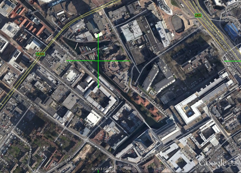
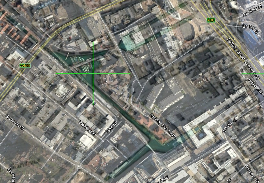
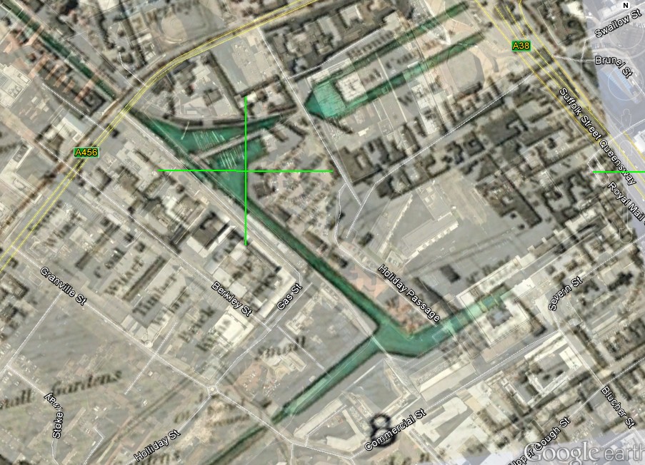
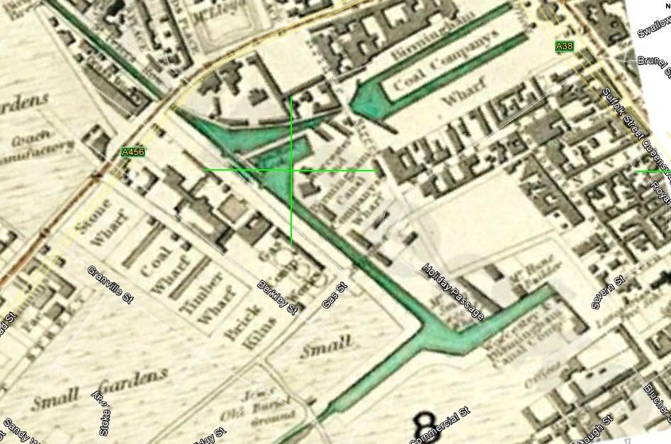
Concerning your query about wharf St, I do not think it would have been in wharf St. I have tried to clarify the matter by superimposing the 1839 map on google. below are 4 views with various degrees of transparency of the map. It is not a perfect match, but i don't think the 1839 map was perfect. It was not north-south to start with, and i had to twist it by variable amounts to get the streets at the right angle. As you can see wharf st approximately follows Holliday st, but not exactly


Concerning your query about wharf St, I do not think it would have been in wharf St. I have tried to clarify the matter by superimposing the 1839 map on google. below are 4 views with various degrees of transparency of the map. It is not a perfect match, but i don't think the 1839 map was perfect. It was not north-south to start with, and i had to twist it by variable amounts to get the streets at the right angle. As you can see wharf st approximately follows Holliday st, but not exactly


