
-
Welcome to this forum . We are a worldwide group with a common interest in Birmingham and its history. While here, please follow a few simple rules. We ask that you respect other members, thank those who have helped you and please keep your contributions on-topic with the thread.
We do hope you enjoy your visit. BHF Admin Team
You are using an out of date browser. It may not display this or other websites correctly.
You should upgrade or use an alternative browser.
You should upgrade or use an alternative browser.
Birchfield Road Perry Barr
- Thread starter debi
- Start date

HI YA DEK
Nice to hear from you again and many thanks for lettin me know that the lotts; are still there ;
i spenta lot of time on that site all those years ago ; mind you i was single then ;every evening after work till dust i was there
at first i went and took it on i found it very stony and clay like it took me years to ferfect the ground
so after hearing from graham ; the history that explains it
best wishes dek have a nice week end ; alan ;; astonian ;;;
Nice to hear from you again and many thanks for lettin me know that the lotts; are still there ;
i spenta lot of time on that site all those years ago ; mind you i was single then ;every evening after work till dust i was there
at first i went and took it on i found it very stony and clay like it took me years to ferfect the ground
so after hearing from graham ; the history that explains it
best wishes dek have a nice week end ; alan ;; astonian ;;;

Did you ever turn anything up Alan? How lovely if you had, as well as reap the benefits of all those veggies.
Lyn, your next mission could require a spade, a trowel, a small brush and a map. Stand by for more details .......... !! Viv.
Lyn, your next mission could require a spade, a trowel, a small brush and a map. Stand by for more details .......... !! Viv.
Hi Alan and Dek,
I haven't been down there for ages myself. I know the playing-fields are still there, but the last time I drove down Wellhead Lane there was what appeared to be a new 'student village' on or near what used to be Holdford Drive. At one time you could walk along Holdford Drive from Aldridge Road to Brookvale Road, skirting the Kynoch Works if I remember correctly. Must go and have another look some time. I believe the water mill was operating until around the mid-19th century and was used mainly for blade-sharpening.
Big Gee
I haven't been down there for ages myself. I know the playing-fields are still there, but the last time I drove down Wellhead Lane there was what appeared to be a new 'student village' on or near what used to be Holdford Drive. At one time you could walk along Holdford Drive from Aldridge Road to Brookvale Road, skirting the Kynoch Works if I remember correctly. Must go and have another look some time. I believe the water mill was operating until around the mid-19th century and was used mainly for blade-sharpening.
Big Gee

This is part of what i had read lynLAND ADJACENT TO THE CROWN AND CUSHION PUBLIC HOUSE,
WELLINGTON ROAD, PERRY BARR, BIRMINGHAM
AN ARCHAEOLOGICAL DESK-BASED ASSESSMENT, 2006
SUMMARY
An archaeological desk-based assessment was carried out in January 2006 on land at
the Crown and Cushion public house, Wellington Road, Perry Barr, Birmingham (NGR
SP 0671 9088
) in advance of residential development. The site is located on the
north side of Wellington Road, adjacent to the Crown and Cushion, and at the
intersection of Walsall Road, Birchfield Road, Wellington Road and Aston Road.
Previous archaeological work to the west along Wellington Road identified
archaeological remains associated with a Roman kiln dating to the second century,
and evidence of settlement from the first and second centuries. The site is also close
to the predicted line of Icknield Street, and spot finds of Romano-British coins, and
the assessment has highlighted the potential for archaeological remains of this
period to survive within the site boundaries. The assessment also highlighted the
potential for archaeological remains of the post-medieval period to be present within
the site boundaries.
thanks tospy...let me at it lol
Years ago I read somewhere that Roman archaeology had also been found around what's now Holford Drive and the area of the playing-fields. I can also remember reading that there was a Roman road roughly along the line of Kingstanding Road/Wellhead Lane/Stoneleigh Road/Wheeler St/Great Hampton Row. How true this is I don't know. When I was a lad people used to say that the Zig-Zag bridge was on the site of what was originally a Roman crossing of the Tame. Most of the Birmingham history and archaeology books I've read have been concerned only with the Middle Ages and later - there doesn't seem to be much published about the history of the area prior to the Norman Conquest. But obviously there was a Roman presence in the greater Birmingham area - ref: Metchley Fort, Icknield Street, etc. Interesting, and worth finding out more.
Big Gee
hi big gee and yes you are correct with the locations of the roman road..it seems that all my life i have never lived more than a 5 min walk from these locations...
lyn
Now had a look at the survey that Topsy mentioned. There are a few maps in there which will be of interest. Here're two of them.
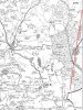 The possible route of Icknield Street. Map from 1775.
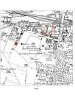 The Crown & Cushion area surveyed and the Roman kiln location from a map of 1890. Interestingly too the original Aston Villa ground is marked for you footie fans.
Viv.
The possible route of Icknield Street. Map from 1775. The Crown & Cushion area surveyed and the Roman kiln location from a map of 1890. Interestingly too the original Aston Villa ground is marked for you footie fans.Viv.
Hi Vivienne,
your map would indicate that the Roman kiln was excavated in the area of Willmore Road and Leslie Road. There was a BCT Bus Garage just there, so I assume that the archaeology was carried out when that building was demolished? I never knew that.
One of these days I really must re-visit the area I grew up in....
Big Gee
your map would indicate that the Roman kiln was excavated in the area of Willmore Road and Leslie Road. There was a BCT Bus Garage just there, so I assume that the archaeology was carried out when that building was demolished? I never knew that.
One of these days I really must re-visit the area I grew up in....
Big Gee
Now had a look at the survey that Topsy mentioned. There are a few maps in there which will be of interest. Here're two of them.
View attachment 74495 The possible route of Icknield Street. Map from 1775.
View attachment 74496 The Crown & Cushion area surveyed and the Roman kiln location from a map of 1890. Interestingly too the original Aston Villa ground is marked for you footie fans.
Viv.
hi viv...thats a very interesting map showing aston villa football ground as was...think i may have mentioned on another thread that that area was known as aston villa..this was well before the football club was formed...i never knew thats where their ground was though...we learn all the time...by the way do you know the date of that map..and can anyone pinpoint exactly where the ground was like i can get my bearings...i do have a rough idea..
oh its ok ive just read the date of that map...
lyn
Last edited:
holly trinty church, i was in the chouir there. from the church along bircfeild road, was the vicarage, which had a gate leading into the church grounds.nexed door was church house, which at the rear had a church hall built in the back garden, i think its still there. over the road from the church, in heathfeiled road was the pub called the bull. opposite the church in trinty road was a guarage, the the church vestry, where the vergey usedv to live. both of thest were demolished, and the mosqie was was built. opposite the bulls head was a caravan sales dept. then going down to where birchfeild house was. just allotments and waste land to haunton road. hope this clearars up some mystreries. sorry about the speeling. kind reguards sidwho
hi sidwho never apologise for any spelling mistakes...its your memories that we want and thanks very much for yours about holy trinity church..i was christened there and still have my christening certificate from 1953.i remember that caravan sales pitch from when i was a girl and im sure our dad had an allotment somewhere round there...i will ask him next time i see him..
lyn
lyn
thanks tospy...let me at it lol
The kiln's supposed to be located at about 224 Wellington Road. Don't know the road so don't know if it's now been built upon. A few details:
The kiln was excavated on the south side of Wellington Road in 1959. Remains of the kiln included tapered clay fire-bars, pieces of the floor, possible fragments of kiln walling, flat stone 'rubbers' used in manufacture and several hundred weights of sherds. The kiln products were 2nd century, but late 1st and early 2nd century pottery indicated earlier occupation of the site.
Viv.

Dave M
Pheasey Born Bumper
viv i think its now known as church road off the aldridge road..next to perry park...st johns church is still there..if i am wrong someone will correct me...
St John`s still there, pics from 2008
Attachments
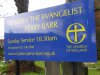
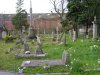
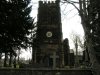
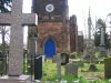
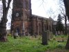
Glad to hear it Dave. But have to admit I don't remember the church interior itself. Yet another place to go on the very long list of places to visit. Many thanks for the photos and the update. Viv.
Hi Vivienne,
your map would indicate that the Roman kiln was excavated in the area of Willmore Road and Leslie Road. There was a BCT Bus Garage just there, so I assume that the archaeology was carried out when that building was demolished? I never knew that.
One of these days I really must re-visit the area I grew up in....
Big Gee
Hi Big Gee. This 1938 map might help you to place the kiln in relation to the bus depot. It's again a map from the Crown & Cushion survey. Viv.
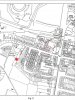
hi viv thats a good clear map showing the spot of the kiln...big gee i agree with you i think its between hirons nurseries and the large house that is next to the nursery but quite a way back off wellington road...probably nothing to see but i will take a look when time permits...
lyn
lyn
Last edited:
Well done Lyn. That's great to have a precise location. Do you know if you can see any it or is it all covered over? Viv.
Just taken a screenshot on GE. Can't see anything, but some nice allotments. Viv.
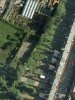
Looking at the GE aerial view at the rear of Willmore Rd houses (red pin is supposed to be roughly about #75) there's what looks like a gravelled/slabbed area between the end of the domestic gardens and the allotments (or garden centre land). Wonder if it's underneath that or a little further along?There looks like there's access to that area through the garden centre. Another opportunity for you to use your fine-tuned powers of persuasion Lyn if you get over there! Viv.

TOPSYTURVEY
brum
225 Birchfield Rd
