• Welcome to this forum . We are a worldwide group with a common interest in Birmingham and its history. While here, please follow a few simple rules. We ask that you respect other members, thank those who have helped you and please keep your contributions on-topic with the thread.

    We do hope you enjoy your visit. BHF Admin Team

Birchfield Road Perry Barr

My Nan Emily Maggie Louisa Feasey lived in Birchfield road during the first world war with her family and I would love to know exactly where?.
 
Hi Jean , don't know about during the first world war years but Emily lived in Franchise Street with her parents in 1901 her parents were still living there in
1911, classed as Handsworth 1901 , Perry Barr 1911.
Emily married Arthur Taplin in 1910 and they lived in Cubbington, Leamington in 1911.
 
Thanks for that Alberta. Chris [Sheera] came across something before the Franchise street move. This is what came up Alberta. here are also first world war army service records for frederick feasey who was the brother of emily maggie louisa feasey. at that time the family were living birchfield rd. perry barr. Would this be of any help?.
 
Thanks for posting the photos of the Birchfield Road shops, showing Maison Celeste (what a posh name)! Plus the ones of the library where I spent many happy hours waiting for an Enid Blyton book to be returned so I could borrow it. Most of the books there in the fifties had plain brown leatherette covers.
 
Found this postcard and thought I'd check out on Streetview what's escaped demolition. Well most of those houses in view on the postcard! Not often you can say that. Viv.

sypehy3u.jpg
 
Found this postcard and thought I'd check out on Streetview what's escaped demolition. Well most of those houses in view on the postcard! Not often you can say that. Viv.

sypehy3u.jpg
Sad how all the front walls have been removed to allow for dropped kerbs and car parking, I noticed that the house where I lived (dewsbury grove) has had the front garden taken up even though there was a garage and parking space to the rear.
 
Birchfield Road in 1910. Anyone know what the structures are on the left-hand side of the photo (enlarged)? I thought they were columns either side of gates to the properties, but not too sure. They seem to be ironwork or is that just a trick of the camera? Viv.

e6ava7ev.jpg

u7u6emad.jpg
 
The columns seem to support a light coloured canopy like the entrances to some churches. A little further along are similar columns with a canopy possibly enclosing a metal gate. On the the other side of the road in the distance can be seen similar columns which I think are front gates to the large houses on that part of Birchfield Rd which looked quite similar in the 1950s until they built the flyover.
 
I think they are brick pillars with a coping stone on the top - a coping stone that is pointed in the middle and meant only for pillar tops.
 
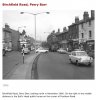
as a regular tram user in the 40's and 50's I have never seen a tram stop like that. Most tram stops, apart from the termini were simply oblong metal signs attachéd to the cable support pole saying TRAM STOP. Eric
 
A view of the Perry Barr Expressway being built in 1968. I'm amazed that quite a few of the Victorian buildings still exist at that end of Birchfield Road especially given the size of the flyover.

sa7ytuga.jpg
ma5ana4u.jpg


Trinity Church is top left in both photos. The road going off to the right (bottom, centre) is Haughton Road. Those houses are still there! It's sometimes very surprising what you can find even today. Viv.
 
Just looked, not sure what it is..
and neither is the person who stated that it is a Mosque in an earlier post.
Pssscht...
I really hope that everyone using this site appreciates the value of accuracy: of the past, in the present and for the future.
 
Perhaps a little respect would not go amiss. If you know what it is then we would welcome your view.

Thank you.


BernardR

Sent from my Nexus 7 using Tapatalk 4
 
and neither is the person who stated that it is a Mosque in an earlier post.
Pssscht...
I really hope that everyone using this site appreciates the value of accuracy: of the past, in the present and for the future.
There's a strong possibility that it may have been a Public House once.
 
And you are right Brumgum. Here's an extract from the digital Handsworth site showing the Bull on the corner of Fentham Road. Viv.


Sent from my iPad using Tapatalk HD
 

Attachments

  • ImageUploadedByTapatalkHD1381733722.769882.jpg
    ImageUploadedByTapatalkHD1381733722.769882.jpg
    108.9 KB · Views: 109
Last edited:
thank you from me too bernard..as a birmingham history forum we are always interested in what happens to our buidings when they are de funked...thats what we do and we can only go on the information found during our research and like i said earlier any member of this forum is more than welcome to correct us if we are wrong so that we can correct our findings if needed

lyn
 
I lived at 4/65 Birchfield road in the 50s,it was at the other end near 6 Ways between Fentham Road and Mansfield Road anyone remember the Dance Hall over the road in Chain Walk? Went to Albert Road primary school,which is where Ozzy Osbourne went was there from 1950 to 1956 Miss Teague was the headmistress,can remember a boy called Kynaston Leach,passed the old 11 plus and went to Handsworth Grammar School,was shocked to have friends who lived in houses with bathrooms and inside toilets!!!!
 
The structures to the left of the first photo were discussed in posts #297-300. I've now found another view which shows them to be gate posts, and my, they were big and solid with a very pointy cap on top. The lamppost is rather nice and elegant too. So Oldmohawk and Shortie, your theory that they were gate posts was right. Viv.

ImageUploadedByTapatalkHD1385390583.843630.jpg
 
A view of the Perry Barr Expressway being built in 1968. I'm amazed that quite a few of the Victorian buildings still exist at that end of Birchfield Road especially given the size of the flyover.
Hi Viv - The houses you mention in #302 can be seen very clearly in the c1920 high res image on britainfromabove. Also in the same image there is an interesting view of Canterbury Road school standing in a white area which I presume is ashphalted. Although I have the hi res image in my laptop I can't upload it here because of the terms and conditions of britainfromabove, but if signed in, the pins can be hidden to see the expanded hi res image via the link below
https://www.britainfromabove.org.uk/image/epw001117?search=birchfield&ref=8
Phil
 
Last edited:
It's after 1953 because the trams have gone, Six Ways looking towards Birchfield Road, and that that white car on the right, anyone know what make is it ?
scan0007-65B15D.jpg
 
Back
Top