• Welcome to this forum . We are a worldwide group with a common interest in Birmingham and its history. While here, please follow a few simple rules. We ask that you respect other members, thank those who have helped you and please keep your contributions on-topic with the thread.

    We do hope you enjoy your visit. BHF Admin Team

A Question Of What?

Dennis Williams

Gone but not forgotten
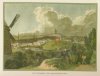
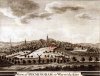
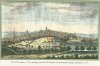
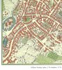
Was trawling through my collection of Birmingham Vistas over the centuries....and noted a building that features in a few of the eighteenth century vistas....and I would love to know more about it, if any genius has any information.....and I feel that this is the place for the answer.....he said hopefully....vistas not in date order....from 1721 to 1826.....so nearly a hundred years of existence....am I barmy, and it is summat obvious?
 

Attachments

  • Birmingham 1826 Thomas Dixon Print copy.jpg
    Birmingham 1826 Thomas Dixon Print copy.jpg
    2.5 MB · Views: 58
  • Birmingham East prospect 1721 copy.jpg
    Birmingham East prospect 1721 copy.jpg
    737.5 KB · Views: 59
  • Birmingham Vista  copy.jpg
    Birmingham Vista copy.jpg
    437.4 KB · Views: 57
  • Birmingham Vista 1779 copy.jpg
    Birmingham Vista 1779 copy.jpg
    1.3 MB · Views: 59
How strange, whatever it is/was its on every picture, doesn't appear to be very big but noteworthy for some reason.

I haven't got a clue, sorry Dennis..
 
Hi Dennis, the building seems to be viewed from Cooper's Mill, looking towards Park Street. On the plan of Birmingham I have, surveyed by Thomas Hanson in 1778, there is a building in the right place (or seems to be) but it has a large square (man-made?) pool in front. I first thought it could be Ladywell baths but would that be up a hill? I'm trying to picture the site and can't. I'll have to find the thread so that we can discount it.
Very puzzling and I do like a good mystery. I'm sure someone will know straight away.
 
The original does label some of the buildings. I attach an enlarged part of the map (even here numbering can only just be seen) and enhanced numbers.
these are:
3n St Martins
4. Market house
5 Baskerville's house Easy Row
6.Free School (bluecoat presumably)
8.M5 Coopers windmill
10 river Rea
11 Mr Coopers house & Waternill
13 New Chapel (St Bartholemew's)

Westley's map (1730) does show a building slightly isolated and vaguely the right position, with area of water behind it.
(see Below)
Still not sure what it was though

part of panorama east prospect birmingham.jpg part of Wesleys map 1750.jpg
 
A curious structure. It looks rather like it was built on a large plinth, but the picture might be a little deceptive. Given that it sits, more or less, at the top of a hill I wonder if it was a former mill with top and sails removed and replaced with a small roof, which is either flat, or sloping one side only. The side we see has a single high window. I suspect the doorway is on the opposite side. The small, but tall size could give support to my former mill theory and presumably it could have been used as a barn On the other hand it may have been a barn in the first instance.
 
A pump house maybe, we have history of such a building locally (Clearwell) in a field called ' The Pump Close' where there was a water supply to the local castle/manor house.
 
On William Westley's plan of Birmingham, 1731 there are two funny little buildings but I've no idea what they are. They both seem to be by gardens though. It would be a good spot for a windmill as Radiorails says. For some reason my map keeps going sideways again. I've tried twice.

image.jpeg
 
Last edited by a moderator:
I've just tried to re-do the picture but it still reverts back as soon as I put it on the forum. Sorry. Edit. Image now rotated.

Anyway, I think Eric Gibson's theory is a really good one because of the proximity to the gardens. The link takes you to Edgbaston Guinea Gardens which are the last remaining examples of the 18th Century Birmingham scheme. I must admit when I first saw the buildings I thought they were garden sheds.

https://allotmentresources.org/links/edgbaston-guinea-gardens
 
Last edited by a moderator:
One more thought - Is the Park Street burial ground anywhere near here?

Also, perhaps they picked this spot for some of the gardens as there was already water being pumped up there for the building with the square pond.
 
In the East Prospect it looks like a small chapel-like building, but not in the other three. Viv.
 
It may well be that the artist/s slavishly copied the detail from the earlier picture.

But having said that it still doesn't explain what the building was.
 
badpenny - as I said in an earlier post, I believe it's a pump house for the gardens behind. On the 1731 map there is another to the side, also in front of gardens. Lots of 'strip' gardens to the left of the original one and below the other one.
 
Wow..So, the very experts I hoped might still tolerate my lurkfulness on here, never let me down….Thanks mike, Viv, Eric Gibson, Lady P and Radiorails……are you still there too Phil?
No matter….so…the options are, if I am correct in my assessment of your suggestions so far….


1. Redundant Mill…minus sails etc….

2. Pump House

3. Shed or Barn

4. Small chapel?

But, as you say, I guess we’ll never really know for sure….anyway eternal thanks……and before I lope off….the amazingly detailed Thomas Archer East Prospect of 1721 also shows this fascinating building I’ve marked in yellow….would this be the first Baptist Meeting House shown on Westley’s 1731 map? According to the legendary Peter Walker…..The first Baptist congregation, known as 'General Baptists', was formed in 1729 and met in Freeman Street. They were also called Arminian Baptists. And they left and joined Cannon Street Baptist Chapel 1754….
 

Attachments

  • Birmingham East prospect 1721 copy-1.jpg
    Birmingham East prospect 1721 copy-1.jpg
    737.5 KB · Views: 26
  • image.jpeg
    image.jpeg
    614.1 KB · Views: 25
Well Dennis, i am consistent, i don't know this one either, but do appreciate your posting very interesting.
 
I remember visiting a display in Coventry cathedral and commented that the depiction of Birmingham on their map showed it as no more than a village compared to Coventry.

As i was later to find out Coventry was more established than Birmingham at the time and the depiction was accurate.
 
It may have been the case, Coventry did have a very large abbey, that with the exception of the charter house was completely destroyed and removed durin the dissolution.
 
I may be wrong here but the way the large maps are sliced here seem to show the wrong area. From the look of the pictures, you should be seeing St Phillips behind the building. This link takes you to a different version of the Westley Map
https://upload.wikimedia.org/wikipedia/commons/8/8b/Birmingham_-_Westley_Map_1731.png and from my guess it's either below the scope of the map or in the field between the road to Coles Hill and Cary Field. There's a Steel House and another building marked but neither of them look right to me so I suppose it's off the map.
 
Ok....there were TWO steel houses depicted in Westley's 1731 map....Kettles in Steelhouse Lane....which I believe is where Steelhouse Lane got it's name.....and another in Coles Hill/The Butts junction...opposite the entrance to the Ditch (which later became the Gullet)...see enclosed from Westley 1731 map, and Bernard Sleigh's 1730 masterpiece......The Old Square also marked....
 

Attachments

  • Carless's Steel House Sleigh 1730.jpg
    Carless's Steel House Sleigh 1730.jpg
    1 MB · Views: 22
  • Kettle's Steel House Sleigh 1730.jpg
    Kettle's Steel House Sleigh 1730.jpg
    319.3 KB · Views: 21
  • Sleigh  1730 Two Steel Works.jpg
    Sleigh 1730 Two Steel Works.jpg
    962.9 KB · Views: 24
  • Westley 1731  Steel Houses.jpg
    Westley 1731 Steel Houses.jpg
    2 MB · Views: 23
Last edited:
East Prospect LHS copy.jpg Westley Middle enl 1731.jpeg

And another thing...whilst we are on Westley's 1731 Map....what does the team think the blue marked semaphore-like poles are in Digbeth in these illustrations....? Tannery Poles for drying leather?...trees......? I've no idea....and it probably isn't that important.....but.....I'm curious....may even still be there in Hansons 1778 map? Not crisp enough for a decent enlargement...but OK...Archer's East Prospect shows them in Digbeth....Westley shows them nearer Park Street....?
 
Last edited:
I asked at the library and was told they were trees but I think this is highly unlikely as the other trees look like trees but these only have branches on one side. I seem to remember the phrase 'tenter poles' but don't know if these are they. Another of life's little mysteries? There are some strange objects on the ground beside them and the whole lot is enclosed by a fence.

The only thing I do know for definite is that Messrs Richard and Henry Geast, Attorneys at Law lived in the house with the garden adjoining these properties and almost on the bridge. In fact their address was Deritend Bridge. All these houses were originally on Deritend Island. They lived there from the 1400's to the early 1800's when the house (probably not the original one) was put up for sale due to the bridge being re-built.
 
Just a thought but besides tanning there were the industries of fulling, scouring and dyeing in the area too so maybe the fabrics were dried on these posts? Be interesting to see what was listed for these properties at that time wouldn't it? Plenty of water around for all these industries anyway.
 
In 1770 Samuel Mayer, silk, worsted and thread dyer and scourer was at no 84. However, unless the numbering has changed (and I see no evidence of this), this was on the opposite side of the road. William Hunt at no 18 was a thread maker , at around the right position, but not sure that a thread maker would need to hang thread out
 
I don't think that the individual items on the maps at that time were properly scaled. For example the fence shown would have to be as high as the width of Digbeth if they were.
 
Thanks Mike, they're either those or poplar trees but just in case I'm putting some tenter frames and poles on.
 

Attachments

  • Tenter ground.jpg
    Tenter ground.jpg
    18.6 KB · Views: 19
  • Tenter.jpg
    Tenter.jpg
    42 KB · Views: 18
  • tenterfields_1.jpg
    tenterfields_1.jpg
    179.7 KB · Views: 18
I wonder if artists/cartographers of the day had a standard set of symbols for their depictions, similar to those we see on

Ordnance survey maps of today?

Once again, i'm afraid it still doesn't conclusively identify what these might be..
 
Back
Top