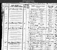
hi john a few people have told me how difficult they find it to search the scottish map overlays but i find it easy..not like me

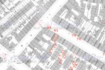
paul there are 2 drop down search boxes on the left...all i do is put in os 6 inch 1889-1913 in the select a map box then in the top box where is says type in a place name put in the name of the street or road you are searching ie brearley street birmingham..having said that i always leave it on those settings because it saves changing the background map which can be a bit difficult
the map will then come up and you can zoom in if you wish and move it about
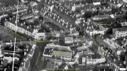
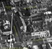
at the bottom of the page on the left you will see a blue dot..just slide it to the right and the old map will fade out to show you what is there today...hope this helps..below is the link and i have left it showing brearley street... below is link to the map which i have left on brearley st for you...
lyn