• Welcome to this forum . We are a worldwide group with a common interest in Birmingham and its history. While here, please follow a few simple rules. We ask that you respect other members, thank those who have helped you and please keep your contributions on-topic with the thread.

    We do hope you enjoy your visit. BHF Admin Team

New unseen photos with no locations

I was a regular 'visitor' with my Dad to the Grosvenor Arms in the early 50's (managed by Jimmy Leach, ex-Villa player) it was certainly NOT a corner pub (surprising how many are !) entrance from Grosvenor Rd or from the rear, Lovers Walk, that and the 'Castle' and the 2 (3?) Queens Rd pubs all long since gone, my only 'local' left there is the Aston Tavern recently restored, Aston as many happy memories for me but I certainly would not go back there now. Eric
 
Last edited:
Happyguy - Yes it does, but you can see from the map that the three roads meet at one point. Prospect Row-Brueton Road would be the most correct description.

Viv - that I don't know, was just trying to explain Eric's recollection
 
I've fiddled around with the original scan , and confirmed that I;m sure that the last part of the fascia says Mitchells & butlers. The first part , though is still a mystery, and the best I get is a negative image below

12part5neg.jpg
 
But is it definitely a pub? Could it be an off-licence/outdoor? Viv.

viv i think the building is to large to be an off licence or outdoor...can see the the landlords name above the 3rd door from the left..cant make it out though...what a mystery..
 
Mike

Sorry I do not have a photo of the Grosvenor, in fact I only have two photos of Grosvenor Rd and they show very little of the road itself. I'm afraid I can't help with this one as it nearly did my head in a couple of years back and I would like to see it named just as much as you would. Just wait one day someone will come on line and say that was my old local it was the ........ and we will all say "why couldn't we see that?"
 
I've also tried to make that out Lyn and thought that its A J & Co or R J & Co. But as most people think all 4 houses are a pub, I thought it couldn't be a business of some sort. (At that point I thought one of the houses - the one on the left - could be an off-licence). Still have a sneaking suspicion there's something else going on there. The three cars made me think of a mechanic's yard. But if there's M & B somewhere on the fascia along that part, seems not. And I still think we're looking in the wrong place. We may never know. Viv.
 
Last edited:
Things I notice about the pic ....
The road with the building is angled to the road in the foreground which has a brick footpath, and the road with the houses appears to be a tee junction with the road with the building .... could this be seen on an old map ?

The second window from the right is thinner than the others ... not much use !

The houses in the pic appear to have the ground windows boarded up and some upper windows have gone so possibly being demolished.

Looks like a pneumatic drill air compressor on the left of the pic.

Maybe we have lost on this pic ....
friendly_wink.png
 
I like your orientation, Vivienne14, yet Dartmouth Middleway is too close to Aston University: the block we see on the horizon is a good mile-and-a-half from the photographer's vantage point. And with Lister Street, Happyguy is virtually on the campus itself.

The streets should lead us there: mikejee is standing on a foreground road looking at the pub, which itself is on a street running close and parallel. To the right is a street leading off, slightly obliquely. With this shape in mind I have compared the 1970s A to Z with this list of Aston pubs https://www.astonbrook-through-astonm...o.uk/Pubs.html

Here are some thoughts:

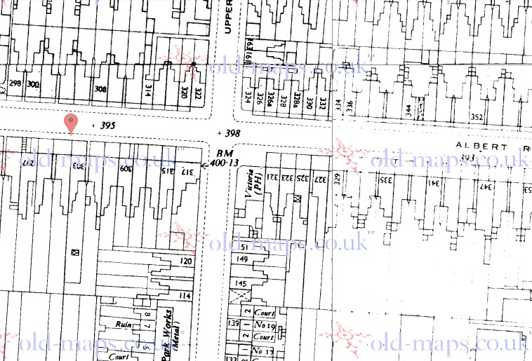
Albert Road - Victoria Inn. A distinct possibility, with Mike standing on Frederick Road.
Alma Street - Alma Tavern, Salutation. Wrong angle.
Aston Hall Road - Aston Tavern. Shot from Priory Road, but unlikely.
Aston Road - White Hart, New Inn, New Peacock, Duke of York, General Wolfe. No.
Aston Road North - Star Inn, Travellers Rest, Albion Inn, Avenue. No. Setting all wrong; we are looking at a side street.
Blews Street - Globe Inn. Too close to Aston University.
Bracebridge Street - Vine Inn. With Aston Brook Street in the foreground this is possible, but probably too close to the university.
Bright Street - Castle Inn. Ruled out by earlier posts.
Brookvale Road - Yew Tree Inn. Wrong angle.
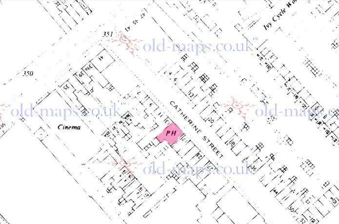
Catherine Street - Three Horse Shoes. Very possible; shot from Portland Street.
Chester Street - Grand Junction. Wrong angle and a bit close.
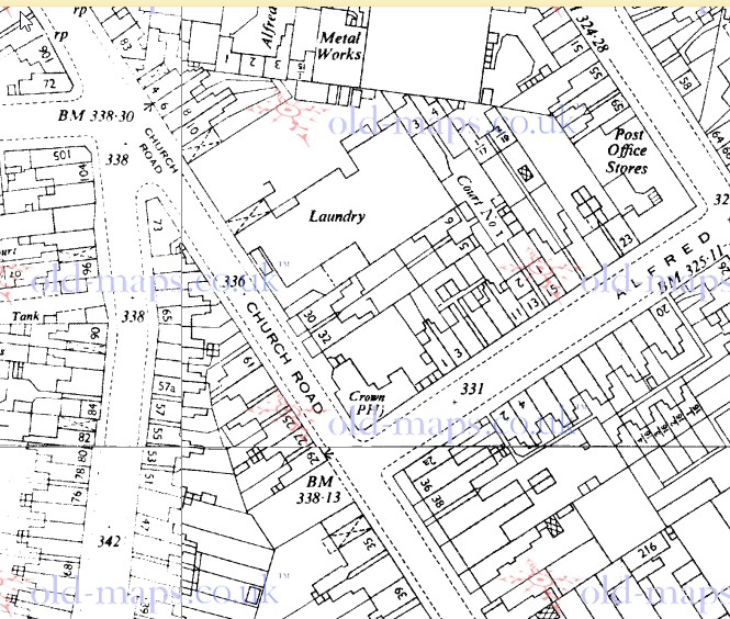
Church Road - Queens Hotel, Crown Inn. Not right.
Clarendon Street - Royal Oak. Clarendon Street not in my A to Z.
Clifton Road - Golden Lion. Possibly.
Grosvenor Road - Grosvenor Arms. Possibly; shot from Lovers Walk - but the foreground street looks too wide for a walk.
High Street - Royal Exchange, Scotch House, Stork, Waggon & Horses, Bartons Arms, Dog & Duck, Malt Shovel. No.
Lichfield Road - Reservoir Tavern, Swan Pool Tavern, Victoria, Vine, Britannia, Church Tavern, King Edward VII, Golden Cross Hotel, Gunmakers Arms. No.
Miller Street - Millers Arms. Too close.
Moor Lane. Wittin [sic] Hotel. No.
New John Street - White Swan. Too close to the university.
Newtown Row - White Horse, White Lion, Vine Inn, British Lion, Clement Arms. As above.
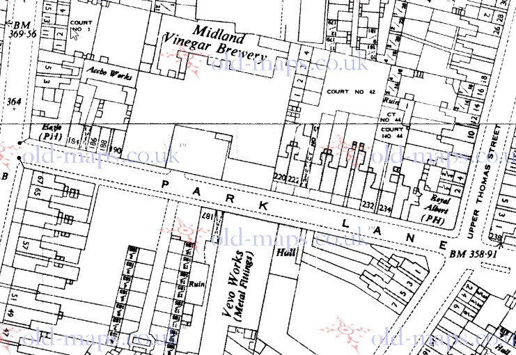
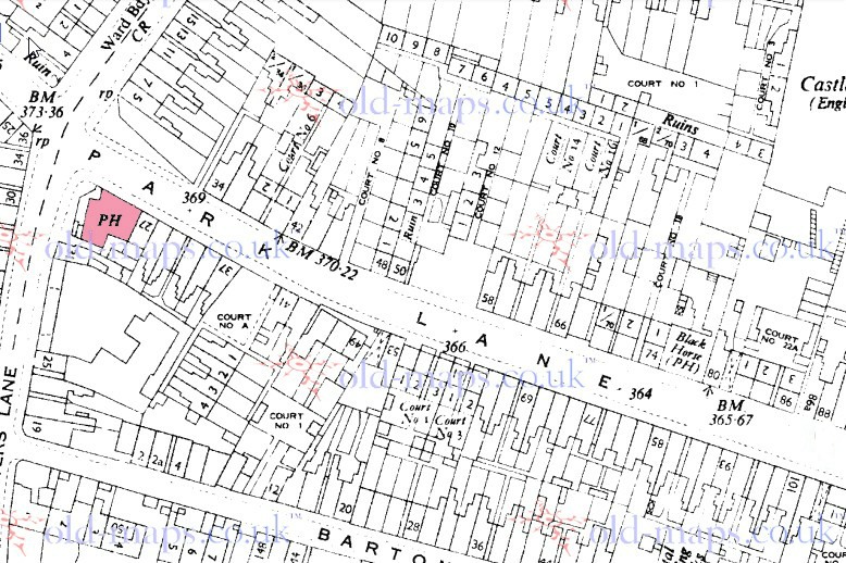
Park Lane - Royal Albert, Shareholders Arms, Black Horse, Eagle Inn. All of these are worth a shufty: angle and distance look promising.
Phillips Street - Talford Arms. Possibly shot from Webster Street?
Portland Street - Manor Tavern. No.
Potters Hill - Tower Arms, Bricklayers Arms. Vantage point on Albert Road?
Pritchett Street - Bulls Head. No.
Queens Road - Queens Tavern. Ruled out by earlier research.
Rocky Lane - Hen & Chickens. No evidence of the foreground street on which Mike is standing.
Sutherland Street - Pump Tavern. Highly unlikely; north of Aston station.
Trinity Road - Upper Grounds Hotel, Holte Hotel. No.
Upper Sutton Street - White Swan, Crown Inn. Angle wrong.
Upper Webster Street - Clarendon Arms. Shot from Burlington Street?
Victoria Road - White Swan, Princess Royal, Queens Arms, Victoria Park Inn. All four of these are possible.
Wainwright Street - New Inns. Possibly.
Whitehead Road - Travellers Rest. Possibly.
Witton Lane - Aston Hotel. No.
Witton Road - Witton Arms, Guild Hotel. Angle awry.
Yates Street - Mazeppa. Location and angle, shot from Park Lane, fit well - but the pub itself does not.

I think we should investigate these few; does anyone have large-scale maps?:

Victoria Inn, Albert Road
Three Horse Shoes, Catherine Street
Royal Albert, Shareholders Arms, Black Horse, Eagle Inn - all on Park Lane.

Your enlargement of the fascia, Mike - how about (in caps) The Adventurer?


clear.gif
Thanks
progress.gif
Thanks
 
Viv & Lyn
Sorry if I confused you. The tarted up enlarged scan i gave was just the left hand sidee. Below is the right hand side, which certainly says Mitch, and it could be utl further along.

12negative_mitchells___butlers.jpg


Aston Lad. Trouble is the Crown seems to be on a corner.

ScreenHunter_708_May__17_19_52.jpg
 
Viewfinder
Just seen your post. Hav eto go offline, but will look at them later tonight.
I incidentally agree that , although it was once a pub, it need not have been when the photo was taken.
 
Things I notice about the pic ....
The road with the building is angled to the road in the foreground which has a brick footpath, and the road with the houses appears to be a tee junction with the road with the building .... could this be seen on an old map ?

The second window from the right is thinner than the others ... not much use !

The houses in the pic appear to have the ground windows boarded up and some upper windows have gone so possibly being demolished.

Looks like a pneumatic drill air compressor on the left of the pic.

Maybe we have lost on this pic ....
friendly_wink.png

Yes, oldMowhawk, the compressor made me curious, too. Above it there is a white-boarded sign with lettering: might be the contractor's notice - or possibly attached to the fence behind. Could anyone enlarge this?
 
Hi Viewfinder - I think the resolution of the pic is not high enough to resolve any of the words in the pic and I've had a real go with the Gimp photo editor. It has been interesting looking at aerial views of the area where there seems to be quite a lot of unused land, empty car parks etc. For example I noticed on the GE historical imagery views that the building or warehouse next to the Adventurer's pub in Queens Road had a completely full car park in 2007 but a completely empty car park by 2009 and empty since then.
oldmohawk
 
I find this building (which is on the right of the photograph ) to be very interesting inasmuch as it has a rounded roof, like an aircraft hanger !. I know its not one of course but could a building like this be a clue to its location. ?12A.jpg
 
thanks happyguy always good to throw ideas out...dont know why but as soon as i saw the photo it didnt strike me as being in aston but more gosta green/nechells way but what do i know lol and im not sure that mike went about with his camera around there...as eric pointed out there were many pubs around at that time..

lyn
 
Last edited:
Yes, oldMowhawk, the compressor made me curious, too. Above it there is a white-boarded sign with lettering: might be the contractor's notice - or possibly attached to the fence behind. Could anyone enlarge this?


I'd assumed the compressor was to power the hammer to break up the old concrete/road. Also assumed it would have been in preparation for a new road development. Maybe we could find out what new roads were developed around the time of the photo wirthin the area. Viv.
 
Absolutely Happyguy. I suggested that the rounded roofed building was an unusual feature in one of my earlier posts. It looks like it is occupied and has net curtains! Very strange. Viv.
 
Last edited:
posting my next one now folks..no location on the back but im pretty sure i know this one..mikes previous photo will still be there so with a bit of luck someone will actually recognise it in time...bet this one wont take long if i know it but it still needs confirming..love the bottles of milk on the step.
 

Attachments

  • img940.jpg
    img940.jpg
    286.1 KB · Views: 212
Is it this one Lyn https://goo.gl/maps/CTsVa
In Bath St

thanks phil thats confirmed what i thought..the gunmakers corner of bath st and little shadwell st just round the corner from the bull at price st...some age to this pub and its still open must go in there again and take a look not been in for some years now

mike its over to you...
 
I find this building (which is on the right of the photograph ) to be very interesting inasmuch as it has a rounded roof, like an aircraft hanger !. I know its not one of course but could a building like this be a clue to its location. ?View attachment 97987
Hi Happyguy - The curved roofs as in the pic are usually wood construction and covered with heavy duty felt. The only ones I have ever seen like that were the halls at Perry Beeches school before they were demolished/upgraded about 1999. Another one I remember was a large hardware type shop called Ibbotsons on the college road near the fire station and library and was there until the 1950s. Maybe the curved roof building in Mike's pic was a school.
 
Viewfinder
It could be I suppose, but don't know of am old pub with that name. To be honest I don't really see anything much in those distorted letters. The Mitc was much clearer.
Below are maps of the pubs you suggested , all the maps from the 1950s. the first shows the victoria, the second the Three horseshoes, the third The Royal Albert & the Eagle and the final one the shareholders & the Black Horse.

map_c_1951_showing_the_victoria_pub_albert_st.jpg


map_c_1950_showing_the_three_horseshoes_pub_catherine_st.jpg


map_c_1951_showing_the_Royal_albert_and_the_Eagle_park_lane.jpg


map_c_1951_showing_the_shareholder_Arms__in_red_and_the_Black_horse_park_lane.jpg


As you can see the Victoria, the Eagle, the Shareholders and the Royal Albert are all on corners. The three horseshoes and the Black horse are not, though maps and directories would seem to imply that they were demolished together with the surrounding houses.There is a picture of the Black horse, park lane at https://www.astonbrook-through-astonmanor.co.uk/parklane.html and it looks nothing like our "pub"
Worth look though. Possibly other members have knowledge of the three horseshoes.
 
I have to say that my brother confirms that the pub in question was on Church Road and Bright Street......but then again he was only young at the time when he lived there,
 
Back
Top