W
-
Welcome to this forum . We are a worldwide group with a common interest in Birmingham and its history. While here, please follow a few simple rules. We ask that you respect other members, thank those who have helped you and please keep your contributions on-topic with the thread.
We do hope you enjoy your visit. BHF Admin Team
You are using an out of date browser. It may not display this or other websites correctly.
You should upgrade or use an alternative browser.
You should upgrade or use an alternative browser.
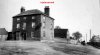
This is a 1910 view of Tyburn House. It looks like a georgian farmhouse. But did it later become the Tyburn House pub? It doesn't look like the Tyburn House pub I remember - the one I remember looked more like a mock 1930s coaching inn. Wondering if the pub was later built on the same site. The site I remember was on the roundabout, the canal ran somewhere on the other side of the building, up past Castle Vale. Viv.

brumgum
Proud to be a Brummie!
Yes it looks very similar to the old Scott Arms, the Tyburn House now is a Sizzler pub belonging to M&B i think. It's very extensive but not sure what it's like now?, i used to have Friday lunch in there when i worked localy..
https://billdargue.jimdo.com/placenames-gazetteer-a-to-y/places-t/the-tyburn/
https://billdargue.jimdo.com/placenames-gazetteer-a-to-y/places-t/the-tyburn/
Thanks Brumgum. Surprised it was originally built as a pub. Not how I'd imagine a georgian pub, just looks too large for a pub, more like a home. That's why I thought it would have originally been a farmhouse (and a very successful farm at that) plus all those outbuildings attached. I think there's more to this place than we read. But maybe it was also intended to offer accommodation for passing coaches. Still seems to me rather large for a georgian country pub/coaching inn. Viv.
chocks2
master brummie
Glad that someone has thrown an element of doubt into the picture of the Tyburn House.
I must admit that I've always believed the pub to have been an earlier pub on the site of the now Tyburn House and the out buildings that you can see on the left of your picture seem to match those that are there now but on looking at the Scott Arms picture (Posted) there seem to be a few minor differences but they do look like one and the same place.

I must admit that I've always believed the pub to have been an earlier pub on the site of the now Tyburn House and the out buildings that you can see on the left of your picture seem to match those that are there now but on looking at the Scott Arms picture (Posted) there seem to be a few minor differences but they do look like one and the same place.
jennyann
Gone but not forgotten. R.I.P.
Hi Viv and Chocks2: Found a bit about the old Tyburn House in the transcript of the murder trial of Abraham Thornton who murdered Mary Ashford in
Erdington in May 1917. The transcript mentions that Tyburn House was originally called The Three Tuns. :
I used to go to dancing at the modern Tyburn House many years ago.https://www.archive.org/stream/trialofadrahamth015892mbp/trialofadrahamth015892mbp_djvu.txt
You have to scroll down a bit to read the bit about The Three Tuns, etc. Such an awful crime.
Last edited:
Thanks Chocks and Jennyann. Yes, absolutely dreadful murder trial. Now we also have a mystery on our hands. The same photo from this site
https://www.sutton-coldfield.net/ashford.html
labels it as a house (the Ashford family) in Langley Heath, now Springfield Road. It says it was the house of Mary Ashford's uncle (farmer) and Mary was a housekeeper there. So according to that site it's not Tyburn House/Three Tuns, but a farmer's house. Perhaps the postcard in post #1 is incorrectly labelled? It pops up on the net quite often, usually labelled as Tyburn House.
 Photo from the 'sutton-coldfield.net/ashford' site
There are also two good maps on the site from the murder trial, must be dated abt 1817. Tyburn House is marked top right on first map.


If there's a different picture/drawing of the original Tyburn Hse/Three Tuns, be interesting to see it.
Viv.
https://www.sutton-coldfield.net/ashford.html
labels it as a house (the Ashford family) in Langley Heath, now Springfield Road. It says it was the house of Mary Ashford's uncle (farmer) and Mary was a housekeeper there. So according to that site it's not Tyburn House/Three Tuns, but a farmer's house. Perhaps the postcard in post #1 is incorrectly labelled? It pops up on the net quite often, usually labelled as Tyburn House.
Photo from the 'sutton-coldfield.net/ashford' siteThere are also two good maps on the site from the murder trial, must be dated abt 1817. Tyburn House is marked top right on first map.
If there's a different picture/drawing of the original Tyburn Hse/Three Tuns, be interesting to see it.
Viv.
That's good thanks Mike. All we need to know now then is what did it look like? Then we can be sure the original photo post #1 is/isn't Tyburn House. My money's on the first photo being yeoman Ashford's farmhouse and not the pub. But will retire gracefully if proved wrong of course!! Viv.
Interesting thread and knew the place well. Had many a bag of winkles or small clams outside there...waiting for hours for parents to come out...ah the good old days. Would never have thought of doing that to my kids. Anyway have posted the link to the 1890 map that seems to fairly well represent the thread starter photo. Never knew Home Farm and that area or there abouts became Castle Bromwich Airfield during and after the war. Ah yes, learned Morse Code in the ATC there. Now if electronicry suddenly fails...I will be ok...so there. I rode my bicycle to Tamworth, past the Inn many times and a couple of us fished in the Fazeley Canal along there a few times. Not much luck as I recall. Just along there whilst crossing over a canal bridge I believe I saw one of the last horse drawn barges stopping 51/52. With the horse digging in it's hooves to stop the barge. The barge was empty and it seems to me only one man was operating it. Still I can't see how that coild be and others here say It would not be possible. Anyway the map looks about right I think and you can see the row houses shown on the right of the Tamworth Road in the photo...also the out buildings seem to be about right. The row houses in the photo are between the two 301 benchmarks on the old map. So I would say that the original photo is the Tyburn or what was there before it. North on the map is about upwards, so look from left to right on the map, for the photo orientation. Strange to think of the times I rode my bike past there...hmm. nice ride to Tamworth, with a couple of jam butties for lunch.
It's funny but just visiting the pub and being around there, you have no incling of the prescence of the canal just immediately north of it. Strange that. Might have all changed now and with recreational boating maybe the pub gets some trade from it.
https://www.british-history.ac.uk/m...d=8816&ox=2994&oy=1385&zm=1&czm=1&x=143&y=155
Thanks Rupert. Looks like I'll have to swallow my pride on this one. Must admit the modern day view of the pub that replaced the original does appear to be on the same incline, but all around it has changed so much. Home Farm on the 1880 map is called Tyburn Farm on this 1928 map. The map was two years prior to the demolition of the original pub. In fact you can barely make out the 'Inn' footprint on the 1928 map, but the farm looks pretty substantial.

Here are a couple of views of the Tyburn from the canal


Never went in the Tyburn, but walked to Minworth along the canal quite a few times. Once did a sponsored walk along there to Tamworth. Had many blisters that day, very painful. On the 1928 map are marked filter beds. I think these are what the locals used to refer to as the 'pig farm' as they tended to smell in summer.
Viv.
Here are a couple of views of the Tyburn from the canal
Never went in the Tyburn, but walked to Minworth along the canal quite a few times. Once did a sponsored walk along there to Tamworth. Had many blisters that day, very painful. On the 1928 map are marked filter beds. I think these are what the locals used to refer to as the 'pig farm' as they tended to smell in summer.
Viv.
Now here's a surprise. Charles Dickens decided to cover the Mary Ashford murder in his publication 'All the Year Round ' in volume 17 of 1867. OK so the main object of the article is the murder, but there are a few wonderful descriptive points of interest about the Whit Monday 'club feast' at the Tyburn (Not too sure what a 'club feast' is but I think it means a Friendly Society event). In true Dickens' style, he gives us a real flavour of what the event might have been like, albeit with an atrocious aftermath. It certainly does not sound like the sort of place a young respectable woman would attend. And I've added a little extract about Thornton's arrest and return to the Three Tuns/Tyburn House. So here we go... Viv.


Anyone know where this is in relation to Tyburn House? Tyburn is marked on the map post # 10. But can't actually place Terry's Lane. Viv.
.
.
Frothblower
Lubrication In Moderation
Terry's lane was renamed Eachelhurst road
