• Welcome to this forum . We are a worldwide group with a common interest in Birmingham and its history. While here, please follow a few simple rules. We ask that you respect other members, thank those who have helped you and please keep your contributions on-topic with the thread.

    We do hope you enjoy your visit. BHF Admin Team
  • HI folks the server that hosts the site completely died including the Hdd's and backups.
    Luckily i create an offsite backup once a week! this has now been restored so we have lost a few days posts.
    im still fixing things at the moment so bear with me and im still working on all images 90% are fine the others im working on now
    we are now using a backup solution

The Moat Yardley

oldbrit

OldBrit in Exile
Last edited by a moderator:
OK so know we know, I was aware that Dare's was the builder, 
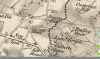
I lived on MOAT LANE right around the corner, SO what was Moat Lane called for? Was there in fact a MOAT at one time? maybe a castle with a MOAT or was Moat another relative of the Dares? John Crump Parker, Colorado USA
Oh, that's a good question. I recall that there is a park in Moat Lane which did have some big dips in the ground & as a child they proved to be great fun to roll down in the snow etc. Could they have been the remnants of a moat of past times I wonder? Fingers crossed that someone might have an answer to solve yet another mystery.
 
I lived near the park,visited lots. I believed the dips were to do with AA guns during world war 2. Could be wrong on that as I was also told they were bomb craters.
 
I lived near the park,visited lots. I believed the dips were to do with AA guns during world war 2. Could be wrong on that as I was also told they were bomb craters.
 
John, I have just had a search around & found that the topic of a possible moat in Moat Lane in times gone by has already been discussed on the forum. It seems that there really was a moat way back in history. There was a farm with a moat corner of Harvey Rd/Yew Tree Lane it was there circa 1939/40 very tatty looking and i thought that was where the Moat Lane name came from. Len.
Erebus555
Re: gilbertstone rec moat lane yardley[/h]
Hey, I haven't posted here in a very long time! To answer the question about the moat, I had a look at a map from the 1880s (I'm afraid I cannot post a screenprint of it due to copyright but it is accessible through Digimap if you have it). The map shows there was indeed a moat alongside the lane although not in the location Len mentioned.

Because Yardley is hardly developed in the map it's hard to work out the bearings of the location but from my deductions, the moat was exactly where the car park and playgrounds for the recreation ground is today. The maps show it was there until at least the 1960s, although it looks like it was nearly all dried up by that point, and by the 1970s the car park and an electrical substation had been built on its site. Immediately west of it (where the rough patch of ground between the houses and entrance to the car park currently is) were four prefabs which were there at least into the 70s.

Now, I'm in my mid-20s so my memory obviously doesn't stretch that far but the 1970s map shows there was a post office in the middle of the recreation ground? I can only assume that this is the reason why the path from the northern car park is more like a road (deliveries) and the path from the southern car park is... well, a path! Where the two converge, the building was. And there was also a playground. Anyway, hope that solves the query!
 
Last edited by a moderator:
..........The area where the dip was never a gun sight, it used to fill with water and beyond that was a pond but it got filled in as kids used to skate on it, when frozen and I think there was an accident many moons ago...........

Dave
 
Last edited by a moderator:
In reply to the original question, this postcard claims to be "The Moat, Yardley". Would it have been near Moat Lane ? There's a bridge and/or a structure in the distance. Viv.

image.jpeg
 
Lots of discussion about the "moat". A map of 1834 shows a moat but it is hard to match it up with a modern map. Have now managed it via maps from elsewhere and it is indeed where the car park is.
 

Attachments

  • upload_2018-5-5_10-7-12.png
    upload_2018-5-5_10-7-12.png
    346 KB · Views: 19
Last edited:
Looks like there was a moat - 1888 map shows. By 1955 it is halved in size by building development.

upload_2018-5-7_7-26-13.png
 
While looking at the above I came across an interesting piece on Moat Lane prefabs (close to the location of the moat on the above maps. I have posted the Link under Prefabs
 
It is probable that the moat was never (other than for a few days) halved. The online maps available from that time sometimes are from slightly different years and were physical on paper, unlike today's , when they are originally online. Therefore, when they were scanned to put them online, on occasion at the join of two maps one shows the position from one year , while the one next to it shows it in a later year. That is why they are often listed as being (say) 1956-63). I think this is what has happened on the map above
 
While looking at the above I came across an interesting piece on Moat Lane prefabs (close to the location of the moat on the above maps. I have posted the Link under Prefabs
[/QU The Pre Fabs across the street from my home My first girl friend June Howell lived in one. Behind the P/F was a park and at the back a small pool in a hollow that we used to go play in
 
Back
Top