• Welcome to this forum . We are a worldwide group with a common interest in Birmingham and its history. While here, please follow a few simple rules. We ask that you respect other members, thank those who have helped you and please keep your contributions on-topic with the thread.

    We do hope you enjoy your visit. BHF Admin Team

The Crescent Ladywood

BordesleyExile

master brummie
Does anyone have any pictures on the Crescent north of Cambridge St? I attatch a 1914 map previously posted by Mike as this will identify the Crescent concerned.
 
Thank you, Viv. I think we can say thats a quality view rather than quantity. Thank goodness for Phyllis Nicklin. There ought to be post 1914 about by other photographers too, but I have not seen any.
 
This was an artists impression of how the Crescent was supposed to look when completed. It was supposed to be residential property along the lines of the Georgian properties of London and Bath. I think the builders ran out of money or some other such reason that prevented completion and the Crescent was never finished to completion.

Nobody quote me on this though as I am only repeating this from memory, but I think the theatre was an afterthought and is was built later converted from three houses.

Phil

Ladywood The Crescent as Proposed.JPG
 
Last edited:
Thank you, Phil. The Crescent seems to have had a chequered history. The Old Crescent Theatre certainly looks more like houses. I'll delve further.
 
A little background from The British Library:

William Hutton wrote in 1809 that the crescent "will consist when finished, of a superb range of twenty-three stone houses, elevated upon a terrace 1,182 feet long, and 17 high. The centre front is 622 feet, and each wing 140 … only 12 houses are finished chiefly in the wings, which cost 10,500. The remainder which are to cost 200. 5,00l are now at a stand, owing, perhaps to the war with France, which has been the destruction of our commerce ... and left in the town about twelve hundred empty houses."

I wonder then if the 12 houses in the wings were the only ones built? Viv.
 
That shed light, Viv, thank you. I had not realised that there was an oversupply of houses at the time.
Apparently according to the sales literature "There is not the least possibility of any future buildings ever excluding the inhabitants from a most agreeable prospect of the country".
Contrast this statement with Guilbert's photos of the general area:
https://www.skyscrapercity.com/showthread.php?t=1054565&page=7
At no 18 was the Crescent Theatre, so you were probably right, Phil.
 
Bartlam's book on Broad St gives this architects vision, and states that only the houses to the left were built, because of the Napoleonic wars, together with new smoky factories putting (rich) people off living in the area. He states that the theatre group formed in 1924 (& presumably the theatre was converted at that time)
 
This plate in Bisset's 1808 Directory shows a view of the Crescent which looks very impressive. Imagine if the original plan had been realised (and had been left for us to admire of course).......... Mike's post 8 raises an important point and questions how desirable this address would be given how close this is to the canal and all its activity. So it must have become a bit of a white elephant. I also wondered whether the building of these houses was intended to target the rising wealthy merchants of the area, especially as they are represented in the plate. I expect the war would have meant leaner times for them. Viv.

https://www.search.revolutionarypla...66&direction=1&pointer=21&text=0&resource=100
 
Was the Old Crescent Theatre building part of The Crescent development? If so there's a 1960s photo by Phyllis Nicklin below. Viv.

https://www.pbase.com/beppuu/image/92164361

Isn't that the Crescent Theatre when it was on the other side of Broad Street, in Cumberland Street? I think the original Crescent was in The Crescent itself, and was built originally as Baskerville Hall. I could be wrong though, often am.

Big Bee
 
Thank you, Viv. Here is the 1888-1889 Old Map showing the fottprint of the buildings at that time. Anyone know where the Old Crescent Theatre was?
 
Its over to the right of that map. Apparently nos 18, 19 the Crescent, which included no 19, which was once Baskerville Hall.c1955 map below shows it in red.
Also another "Prospective View of the Crescent ", from Gill's "History of Birmingham"

Crescent_theatre__The_Crescent_map_c_1955.jpg
 
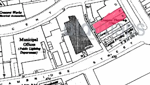
Showell's Dictionary gives an interesting description of the Crescent and Wharf. It sounds less upmarket than I thought. looks like the land was leased from the Grammar School:

"When built it was thought that the inhabitants of the handsome edifices here erected would always have an extensive view over gardens and green fields, and certainly if chimney pots and slated roofs constitute a country landscape the present denizens cannot complain. The ground belongs to the Grammar School, the governors of which leased it in 1789 to Mr. Charles Norton, for a term of 120 years, at a ground rent of £155 10s. per year, the lessee to build 34 houses and spend £12,000 thereon; the yearly value now is about £1,800.

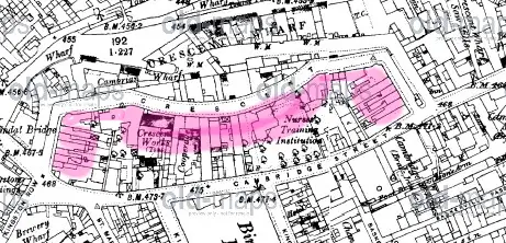
On the Crescent Wharf is situated the extensive stores of Messrs. Walter Showell & Sons, from whence the daily deliveries of Crosswells Ales are issued to their many Birmingham patrons. Here may be seen, stacked tier upon tier, in long cool vistas, close upon 6,000 casks of varying sizes containing these celebrated ales, beers, and stouts. This stock is kept up by daily supplies from the brewery at Langley Green, many boats being employed in the traffic."

So as well as the change in european markets, maybe they didn't anticipate the full impact of the popularity of the canals. Viv.
 
So the Old Crescent Theatre was round the corner from the crescent curve, Mike. I had not looked far enough, so thank you for clarifying - I was puzzled as the theatre architecture differed from the views, aspirational or real, of the Crescent proper.
Thank you for the excerpt form Showells, Viv. What a picture it paints. Interesting that a brewery outside Birmingham was the chosen supplier.
I do wonder if one of the issues was that Charles Norton leased too small an area of land to secure the quality of location, a lesson learnt & applied by modern house builders. According to Bob Miles Baskerville's land was sold to John Ryland who left it to his son Samuel who in turn leased it to Thomas Gibson who cut the canal. I have not looked at the various dates or for land ownership boundaries yet. It would be interesting to know what the houses in the Crescent were leased out for. I am aware that wealthy &/or pwerfull people lived in the Crescent, including one of the Attwoods.
https://bobmiles.bulldoghome.com/pages/bobmiles_bulldoghome_com/morejbask.htm
 
A couple more images concerning the Crescent. One shows a part of the Crescent that survived until the 60's. Then there is a costing for the building of the Crescent that I can't pretend to understand, all I can think that I understand is that it was supposed to cost around £18,500. Perhaps someone understands it better than I.

Phil

Ladywood the crescent.JPGLadywood Costing for the Crescent.JPG
 
Last edited:
I am not 100% sure that this refers to "our" Crescent, but cannot see where else it would be. These cuttings from 1797 and 1800 would imply that a school occupied part of the Crescent

St__James_s_Chronicle_or_the_British_Evening_Post_28London2C_England292C_July_182C_1797_-_July_202C_17973B_Issue_6176_.jpg


St__James_s_Chronicle_or_the_British_Evening_Post_28London2C_England292C_May_272C_1800_-_May_292C_18003B_Issue_6622_.jpg
 
Thank you, Phil & Mike. The dates tie in well. I know that schools were often set up in the centre of Birmingham a little later in the 1800s by women apparently interested in earning a living. The 1960s picture is really helpfull as when I lived in Birmingham I never had need to visit the Crescent & I find it difficult to visualise that area. I do not understand the costings either, but they are important for the dates they provide. Where did you find that document, Phil?
 
Attached are a couple of sections from "Old and New Birmingham" (Dent, pub 1880).
The first attachment refers to the Crescent having been the original site for a hospital for the reception and treatment of Women afflicated with diseases peculiar to their sex...."
The other attachment refers to a description of the proposed Crescent and leasing of land from Kings Edwards School.
 
Last edited:
Enjoying reading and seeing all the information people are uncovering about the Crescent. The costings in Phil's doc 2 post 17 look very broad brush and maybe the project wasn't adequately costed/funded in the first place. Just a thought. I also like the extracts in Mike's post 18 - such enterprising and confident ladies for their time to, not only set up a school, but to publish educational materials. And the 2nd doc in Leslam's post 20 seems to me be slightly overworking the 'extensive prospect that can never be interrupted by other buildings'. These references build a fascinating background for something that was never completed.
I came a across this reference in British History online which talks about the Crescent and a little taster of the nearby area
:

"only the flanking wings had been completed and the project was said to have failed because of the depression caused by the French wars. The five houses which remain, representing the east wing,
have been converted into the Crescent Theatre, their rather plain stone facades having been
preserved intact. In the 19th century this area rapidly became unsuitable for residential development owing to the concentration of industry along the canal. A half-derelict survival of its earlier phase is in Kingston Row, a street formerly crossing the canal, where the stucco fronts of five terraced houses incorporate small-paned shop windows. Further south St. Peter's Place and St. Martin's Place, the
latter a long terrace of late-18th-century brick cottages with small front gardens, form together a
quiet backwater with almost a village atmosphere"

Am I reading this right i.e that the original theatre was part of the Crescent buildings? Viv.
 
I have taken this from the history page of the Crescent Theatre's website

History of the Crescent Theatre

The Crescent has a history going back to December 1923 when a few City Council employees entertained their colleagues with a Christmas party revue. They discovered, in the words of Noel Coward, that they had "a talent to amuse".
They also had ambition - to raise the funds to acquire their own theatre within a decade. Plans were made at a meeting on 30th January 1924 and the Municipal Players were in business. For the next seven years plays were mounted in the Council House canteen and at the Midland Institute while fund-raising progressed. In 1931 the opportunity came to lease premises at Nos. 17, 18 and 19 The Crescent, together with the derelict Baskerville Hall behind. With bare hands and hired tools the Players converted the decaying buildings into a theatre with raked auditorium, stage, dressing rooms and workshops and this opened with much national and local press publicity in April 1932.
 
Thank you, Leslam. Its always good to have an older source. Well not many of the builder's intentions mentioned in Dent came to fruition. Charles Norton was assigning land in Tipton in 1798, so perhaps he was raising funds. There was also a Charles Norton involved in land deals in 1806 & in 1813 involving New St land. Whether it was the same Charles Norton or father & son is not clear.
 
Viv
As i understand it, the original plans envisioned a building covering something like the ground coloured pink in the 1890 map below. This makes the Crescent theatre part of the east wing (seen on the far left of Phils original picture

The_crescent_plans_on_1890_map.jpg
 
Thank you, Viv for the British History Online passage. It had not occurred to me that Kingston Row was built by the same builder so I'll look further into that.
Charles Norton was involved in building the 2nd New St theatre, though that was destroyed by fire. I hope that some of his ventures were more successfull.
https://www.arthurlloyd.co.uk/Birmingham/TheatreRoyalNewStreetBirmingham.htm
Thank you for demonstrating the intended footprint of the Crescent, Mike. Its starting to make sense now.
 
Looking at Mike's map in post 24 I have now orientated myself. I remember the Crescent as when i was a boy my dad used to take me into town on Saturday mornings once a month when he went to the bank and did the rounds of all the offices paying the household bills. He always used to park in Cambridge Street at the back of the Civic Centre (now Baskerville House) I was always puzzled by the Crescent because it was not Crescent shaped but a straight row of buildings. When I read a long time ago that it was incomplete I assumed that the existing buildings were the West end and that the crescent would sweep round to the east with the houses facing south. It is only now that I see that the crescent would face north and that the buildings as built were in fact a return wing at the east end of the crescent. This has solved for me a long outstanding puzzle.
 
Yes agree Mike's map has made it much clearer. Thanks for that. The scale of this enterprise is quite stunning (and adventurous). I have another question. There may be an obvious answer but in Mike's picture post 14, is it the canal being built in front of the Crescent or is it something else? Viv.
 
The Newhall Arm of the Birmingham Canal was built 1768-72 so predates The Crescent. However unless there was a change of name at sometime Crescent Wharf must be later than the Crescent.
 
I am no canal expert, but its said that the Birmingham & Fazeley Canal is recognised as starting from by what is now the NIA Cambridge St. That is the B&F that is nearest to the Crescent. I have yet to verify the date but I have read that in 1784 it was agreed that the B&F canal would be built.
 
The Birmingham Canal Newhall Arm is the canal nearest the Crescent, the Birmingham & Fazeley can just be seen near the top left of Mike's map leading off from Farmer's Bridge junction. Farmer's Bridge top lock is marked by BM 456.2. The junction at NIA / back of ICC/ Sea life Centre known as either Deep Cutting Junction or Old Turn Junction (It has two names as it is a double junction) is the junction of the Newhall and Paradise Arms of the Birmingham Canal.
 
Back
Top