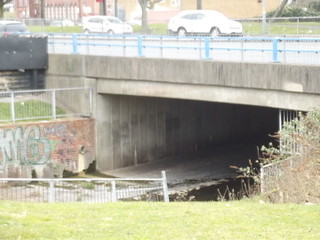
Odd. I went to King Edwards Camp hill between 68 and 73 and lived on the Pershore Rd in Edgbaston so I went up and down Cartland Rd every school day for 5 years. It was a fair climb but it was never flooded in that time. I would have noticed as there wasn't an easy way round it. I know it has flooded badly since and wonder what changed.WE lived in Kitchener Rd then Cartland Rd in the 90's. We would quite often cycle or walk along the path into Cannon Hill Park alongside the Rea. It was cleared out in the 80's and quite often carried flood water in heavy rainfall times. Anyone who has seen Stirchley in a storm will know how the drain covers explode into fountains. Cartland Rd used to flood regularly. I have a Photo of our house under 3 feet of water.
-
Welcome to this forum . We are a worldwide group with a common interest in Birmingham and its history. While here, please follow a few simple rules. We ask that you respect other members, thank those who have helped you and please keep your contributions on-topic with the thread.
We do hope you enjoy your visit. BHF Admin Team -
HI folks the server that hosts the site completely died including the Hdd's and backups.
Luckily i create an offsite backup once a week! this has now been restored so we have lost a few days posts.
im still fixing things at the moment so bear with me and im still working on all images 90% are fine the others im working on now
we are now using a backup solution
You are using an out of date browser. It may not display this or other websites correctly.
You should upgrade or use an alternative browser.
You should upgrade or use an alternative browser.
The maps on post 83 are not orientated similarly. To be correct the bottom map needs to be rotated 180 degrees to match the top one. Great Bar became Heathmill at Fazeley. To match up to the 1890 survey both maps will have to be rotated 90 degrees again. Both maps are new (to me anyway) and carry this aspect of the thread a bit further. Is there any more of the bottom map because it shows a wider section of water ending at Fazeley St. It does show a leat close to the junction of Heathmill/Fazeley/Great Bar and I have seen this on another map before, somewhere but thought it was just a sketching abberation. Don't think that now. But still stick to the theory that the subject house on Fazeley street is the location of the house on Westleys Aspect. The routing of the Rae after the so called floodgate may have been closer to the elevated mill pool. The second map on post 83 may show a later mill closer to Heathmill Lane intersection or maybe a tannery. Anyway it seems pretty certain that water crossed Fazeley there also and the pool reached up to that point.
The red line on the first map is the run of the 'viaduct to nowhere'. Great stuff. Will try and post another map if I can find it.
It all seems like an awful lot of effort to go to, making a watermill here. Does not seem like much head to be gained and even then, the back up flooded the causeway back at Derritend; requiring a brdge to be built. Even after all of this only a breast shot mill could be built. Perhaps a later mill closer to Heathmill Lane may have gained more head...it seems to be slightly up hill to there. Everything at this crossing is gone now.
The Piggott Smith doc. is a map that I have seen before on here and it shows more of the mill pools and a large triangular mill pond separated from the main run by a seeming causeway which might have become Floodgate St. maybe. I read somewhere that water was scarce and stored in places for dry periods...before steam power rescued us all. So prior to this time the first water mill was along there somewhere with a simple long pond the actual point of the head race is a bit troublesome but...the current house position looks so darned right on Fazeley St. and things were...fluid. The original long pond could easily have been further down the street. I think the doc map is about 1828.
On the doc map if you go down to the bottom you can see the Old Ship Inn I believe. At the top of Bradford Street. My headquarters in the civil war birmingham raid.
Attachments
OK, I think I may now have a handle on the way references to the Coppermine works. Hopefully they should appear here:
https://images.birminghamhistory.co.uk/coppermine/albums/userpics/10449/GWR_11476.jpg
https://images.birminghamhistory.co.uk/coppermine/albums/userpics/10449/After_J_Piggot_Smith_1825.jpg
These two new images are from my digital scans of the Birmingham and Oxford Junction Railway Contract Drawing which resulted from a survey which would have taken place around 1845-6 in readiness for the Act of Parliament presented in 1847. The output was further processed to provide an graphic map of the scene prior to the construction of the Birmingham viaduct as it was known then. I am not sure when it became known as the Duddeston Viaduct.
The land boundaries appear in green, the buildings in grey, the Warwick Canal and Rea in blue and the viaduct abutments in brown strung along the red centreline.
The second is a partial digital scan of J Piggot Smith's street map of Birmingham which was first published in 1825 and later revised in 1828 which provides some context.
As before the coloured lines signify the boundaries, roads etc. and the purple line the boundary between Aston and Bordesley.
The drawings have been calibrated and oriented to the JPS alignment which should make comparison a lot easier. As far as my digital model is concerned I am working in Chains, Links and Feet!
The Contract Drawing shows what I believe is the culverted part of the original Rea following initially the ward boundary before heading off along the current alignement of Montague Street though there is no reference to this in the drawing.
On my next trip to Kew I will look at the Contract between Peto and Betts who built the section between Oxford and the boundary with the LNWR at Curzon Street to see if there is any reference to this as clearly the bridge abutment is mighty close.
From what I remember of the detail in the City Council histories, the floods didn't come until after 1846 (when the contract drawings were dated) so there shouldn't have been plans to culvert the river at the time. The major works including the culverting didn't happen until the 1890s.
The purple line defines the boundary of the Parish of Birmingham along it's eastern side which largely followed the main course of the Rea as far as Speedwell before heading northwest to Islington Row and Five Ways etc.
The small river meeting the Rea in the upper left corner of the map appears first a short distance east of the Proof House beneath the Birmingham Canal and may have been a means of maintaining the canal level. Piggot Smith's map isn't too precise on this and it may flow from further north beneath Curzon Street from the higher ground beyond.

Coopers Mills isn't identified clearly on his map but from Pye's 1795 map it does appear to straddle the Rea at the junction of Fazeley Street and Liverpool Street so in my version (After J Piggot Smith 1825.jpg) it is likely to be the L shaped building at the junction.
Pye's map is clearer

There is a lot of good stuff on this area at:
https://archaeologydataservice.ac.u...502-1/dissemination/pdf/birmingh2-48533_1.pdf
The small river meeting the Rea in the upper left corner of the map appears first a short distance east of the Proof House beneath the Birmingham Canal and may have been a means of maintaining the canal level. Piggot Smith's map isn't too precise on this and it may flow from further north beneath Curzon Street from the higher ground beyond.
Coopers Mills isn't identified clearly on his map but from Pye's 1795 map it does appear to straddle the Rea at the junction of Fazeley Street and Liverpool Street so in my version (After J Piggot Smith 1825.jpg) it is likely to be the L shaped building at the junction.
Pye's map is clearer
There is a lot of good stuff on this area at:
https://archaeologydataservice.ac.u...502-1/dissemination/pdf/birmingh2-48533_1.pdf
From what I remember of the detail in the City Council histories, the floods didn't come until after 1846 (when the contract drawings were dated) so there shouldn't have been plans to culvert the river at the time. The major works including the culverting didn't happen until the 1890s.
Thanks Jim,
It may be that work to alleviate the old route of the Rea near to the pier foundations at Montague Street was covered in the Specification of Contract which was awarded to Peto and Eastted in 1849 for constructing the section from Bordesley northwards toward Curzon Street.
The document is in RAIL 39/497 at Kew but I only managed to speed read a few dozen pages at my last visit before the going home bell sounded.
I have to admit I love maps and the stories they tell and particularly when you make a discovery that has been staring you in the face for weeks.
When I visited the National Archive earlier in February I was mainly interested in stuff related to the Duddeston Viaduct but their referencing system is largely based on the original document owner or donor providing an accurate description in the first place.
For instance one of the big drawings produced by Brunel and his assistants for the Deritend Viaduct (GWR 11500 TNA Rail 39/11) included an elevation view of a canal bridge which made no sense as did the hand written pencil notes and sketches which were hardly decipherable.
In another document prepared by a local surveyor for the on going legal battle between Captain Huish and his LNWR railway and the GWR (TNA Rail 39/413) it showed how the triangle bounded by the canals and the Duddeston viaduct had already been parcelled up for development probably based on Piggot Smith's maps. Through it of course runs the Rea making this arguably "on topic".
On this map was a peculiar dog leg shaped feature crossing the BCN canal which had four crenellations on its south east face.
So attached is a melange of a digital scan of the surveyor's map overlayed with a scaled scrap taken from Brunel's larger map plus a scrap from an 1859 map showing the Gas Works on Lower Fazeley Street by which the Rea also flowed.

Of course the Duddeston viaduct (pink) only reached the boundary of the LNWR (shaded blue) and remained that way until the mid 60's before finally vanishing under the lines around the Proof House which were further developed.
The circular feature in parcel 557 remains mystery however.
When I visited the National Archive earlier in February I was mainly interested in stuff related to the Duddeston Viaduct but their referencing system is largely based on the original document owner or donor providing an accurate description in the first place.
For instance one of the big drawings produced by Brunel and his assistants for the Deritend Viaduct (GWR 11500 TNA Rail 39/11) included an elevation view of a canal bridge which made no sense as did the hand written pencil notes and sketches which were hardly decipherable.
In another document prepared by a local surveyor for the on going legal battle between Captain Huish and his LNWR railway and the GWR (TNA Rail 39/413) it showed how the triangle bounded by the canals and the Duddeston viaduct had already been parcelled up for development probably based on Piggot Smith's maps. Through it of course runs the Rea making this arguably "on topic".
On this map was a peculiar dog leg shaped feature crossing the BCN canal which had four crenellations on its south east face.
So attached is a melange of a digital scan of the surveyor's map overlayed with a scaled scrap taken from Brunel's larger map plus a scrap from an 1859 map showing the Gas Works on Lower Fazeley Street by which the Rea also flowed.
Of course the Duddeston viaduct (pink) only reached the boundary of the LNWR (shaded blue) and remained that way until the mid 60's before finally vanishing under the lines around the Proof House which were further developed.
The circular feature in parcel 557 remains mystery however.


Speedwings post #83 raised a point that the remains of Coopers Mill and house might be on the council car park which seemed questionable at the time. Well, everything seemed to tie it to modern day Lower Fazely Street....it just seemed so right, to me anyway. Maybe it still is correct but, as we go on, more and more details and pictures and research emerges; some seemingly un-related at first anyway. I know...maybe an obsession of mine ...but I find it all interesting anyway.
So taking Speedwings above assertion and trying to think around it...what do we reasonably know.
Firstly the Westley Prospect is earlier than the later maps and before accurate surveying was possible.
It shows a long narrow pool that would have been formed by damming the river up-stream at the floodgate (dam).
This pool was south of the river Rae and fed the old tandem mill shown on the Westley Prospect.
Later maps show a larger triangular body of water with Floodgate Street passing through the middle of it on a causeway and ending at Lower Fazely Street.
This pool seems to have fed a number of mills in the same complex 'fronting' on Lower Fazeley St.
This later pool surface level would have been at or possibly above that of the canal.
Later, the canal was built 'behind the mills' east of lower Fazely Street...the Rae and mill tailraces passing under the canal...this would have all been spent water combining below at Montague St.
So, all would work harmoniously and the triangular reservoir would remain in place for as long as it was needed prior to steam power taking over.
Where was the Old Coopers Mill and house shown on Westley's Prospect? Speedwings assertion about the council parking lot is intreagueing and how long could the remains possibly have lasted I wonder.
Recently an aerial photo, taken in the twenties I believe, was referenced (can't find origin and not sure of the dating). Anyway it showed this area and, although in the distance, the area in question was shown and could be blown up and it shows a structure remarkably like the old Cooper House. Also remarkably on the other side of the Canal and right on the towpath seemingly. Could it be that the later mapped mill complex and triangular reservouir were built up-stream of the old Coopers Mill which might have been disused at that time. If so Coopers Mill (a la Westley) would never have been on the Lower Fazeley Street as we know it but further east of it and the Canal would have been built in front of it...the towpath seemingly right in front of it. It would have been at the level of the canal which would be correct if the tailrace from the mill was to drain down into the Rae below. Obviously disused by now and maybe left to crumble.
Anyway a few pictures to follow for those interested as soon as I can sort out.
Dear Rupert,
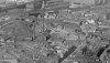
Not sure whether this is the aerial photo you refer to, it was taken in the late '20s and was part of a sequence which covered Bordesley to the Markets area from east to west and is from the English Heritage Aerofilms archive available online. The aircraft's flight track was roughly parallel with Moseley Street as Cheapside was also visible in the original frame.
https://images.birminghamhistory.co.uk/coppermine/albums/userpics/10449/5841_mono.jpg
This image has been clipped from the original which showed much more south of Digbeth High Street and the viaduct. It has also been quite heavily post processed to reveal as much detail in the background and especially of the Duddeston viaduct which runs from centre right to the "junction" with the LNWR railway line near Banbury Street cattle sidings.
The "dog legged" street on the right hand side is Heath Mill Lane/Great Barr Street with Fazeley Street running left/right across the middle of the frame.
Beyond but not easily visible but running east/west almost across the middle of the picture is the Oxford Canal
The tall chimney in the middle of the picture is the Salvage Department "destructor" with the extant Rea "dog legging" northwards beneath the old viaduct beneath Montague Street.
Floodgate Street runs north eastwards under the Deritend viaduct to its junction with Fazeley Street at a point close to the old gas works.
If correct the Cooper's Mill site would lie somewhere east of the old gas works and the Heath Mill Lane/Fazeley Street junction.
Attachments
Last edited:
Ok Speedwing I can't seem to expand your picture. Anyway thanks for replying; I was hoping that you would.
Below hopefully is a blow-up of the area in question. The frontage in question is to the right of the large chimney and seems to be remarkably similar to the frontage on Westleys Coopers house which was just above the mill building. Remember it is all well before the maps and canal and later mills. This is not the council lot but darn close to. I don't know about dates but the old mill would have had to have stopped working before the canal was built. Trouble with all of this is that there is no distinction between possibly earlier buildings and later ones...if there was such a demarckation. The mill itself as ever would have had to be higher than the river. So remains would not be very deep...pretty much canal level. That is if it was there.
The road leading up from centre bottom to the right is Floodgate St. At centre bottom leading up to the left is River St. Both of these streets end at Lower Fazeley St. Lower Fazely St. runs to Heath Mill lane at the junction with Great Bar St. So the frontage in question is further back on the far side of the canal...just. Seems to have rounded frontage.
Attachments
ellbrown
ell brown on Flickr
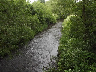
The "leading into Calthorpe Park" would probably be better written as facing Speedwell Rd as Calthorpe Park covers the green space behind the camera as well. It used to be that the river was the boundary of the park but they've moved the river since then.
Yeah I meant Speedwell Road also. But then I walked into Calthorpe Park.
Taken on my mobile, so didn't want to risk taking photos of the river (didn't want to drop it!).
Dear Rupert,
I doubt any of the features present in Westley's Prospect of around 1730 survived the arrival of the canals and later the railways in the 18th and 19th centuries. I have read elsewhere that by 1836 the site of the mill was subsumed into a steel drawing mill which occupied the land immediately west of the present Forge tavern (Pevsner?)
I popped into the new Library of Birmingham this morning to re-acquaint myself with the map cupboards and found a few items of interest to this specific area of town.
Maybe you have seen these already but they provide a useful timeline.
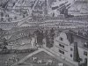
Firstly Westley's prospect:
https://images.birminghamhistory.co.uk/coppermine/albums/userpics/10449/P1020553a.jpg
Next a Prospect from the South-West showing the Rea passing beneath Deritend bridge and on past Cooper's windmill and some buildings nearby which may be Cooper's farm and water mill shown in Westley's.
https://images.birminghamhistory.co.uk/coppermine/albums/userpics/10449/P1020555a.jpg
Next another view from the south-east again with both the windmill and Cooper's farm though without the water mill
https://images.birminghamhistory.co.uk/coppermine/albums/userpics/10449/P1020558a.JPG
Finally another Prospect, again from the east, only much later and with considerable development where it is just possible to make out the Rea and bridge.
https://images.birminghamhistory.co.uk/coppermine/albums/userpics/10449/P1020562a.JPG
I am sure that with a bit of clever plotting it might be possible to work out where these features originally lay by reference to St Martins church etc. though given the conjectural nature of the originals this may a difficult task as it could be that he depictions in each of the prospects were often to satisfy the sponsors than representing strict reality.
This was unearthed later and makes interesting reading (from https://www.bgfl.org/bgfl/custom/re...ory/jm_jones/aston_manors/bordesley/page8.htm)
"By 1651 Deritend Bridge was 'so utterly demolished' through neglect that it looked like a casualty of the war. Since the dissolution of the Birmingham Gild of the Holy Cross that had maintained 'two great bridges of stone' across the Rea channels, nothing had been done to them. The local Justices had disclaimed respon-sibility for more than a century, but they were now required to restore the bridge. Hemill (Hay Mill) Bridge was first recorded on Ogilby's strip-map of 1675, but it was probably a footbridge only at that time. Of about that date were A-B House (Aston-Birmingham) beside the bridge, raised on piles above floods, and two Dutch-gabled houses: Coopers Farm alongside the dormered watermill (Belmont Row off Montagu Street) shown on Westley's Prospect, and Ravenhurst, the Lowe mansion (site of St. Anne's R.C. School off Bradford Street). Of the Stuart Owens' Farm one much-repaired brick building in Farm Park is said to be the house. In 1697 William Simcox bought Stratford House, the Rottons' timbered mansion of 1601, and an estate of 20 acres. He or an heir rebuilt the back of the house in brick with sash windows"
I doubt any of the features present in Westley's Prospect of around 1730 survived the arrival of the canals and later the railways in the 18th and 19th centuries. I have read elsewhere that by 1836 the site of the mill was subsumed into a steel drawing mill which occupied the land immediately west of the present Forge tavern (Pevsner?)
I popped into the new Library of Birmingham this morning to re-acquaint myself with the map cupboards and found a few items of interest to this specific area of town.
Maybe you have seen these already but they provide a useful timeline.
Firstly Westley's prospect:
https://images.birminghamhistory.co.uk/coppermine/albums/userpics/10449/P1020553a.jpg
Next a Prospect from the South-West showing the Rea passing beneath Deritend bridge and on past Cooper's windmill and some buildings nearby which may be Cooper's farm and water mill shown in Westley's.
https://images.birminghamhistory.co.uk/coppermine/albums/userpics/10449/P1020555a.jpg
Next another view from the south-east again with both the windmill and Cooper's farm though without the water mill
https://images.birminghamhistory.co.uk/coppermine/albums/userpics/10449/P1020558a.JPG
Finally another Prospect, again from the east, only much later and with considerable development where it is just possible to make out the Rea and bridge.
https://images.birminghamhistory.co.uk/coppermine/albums/userpics/10449/P1020562a.JPG
I am sure that with a bit of clever plotting it might be possible to work out where these features originally lay by reference to St Martins church etc. though given the conjectural nature of the originals this may a difficult task as it could be that he depictions in each of the prospects were often to satisfy the sponsors than representing strict reality.
This was unearthed later and makes interesting reading (from https://www.bgfl.org/bgfl/custom/re...ory/jm_jones/aston_manors/bordesley/page8.htm)
"By 1651 Deritend Bridge was 'so utterly demolished' through neglect that it looked like a casualty of the war. Since the dissolution of the Birmingham Gild of the Holy Cross that had maintained 'two great bridges of stone' across the Rea channels, nothing had been done to them. The local Justices had disclaimed respon-sibility for more than a century, but they were now required to restore the bridge. Hemill (Hay Mill) Bridge was first recorded on Ogilby's strip-map of 1675, but it was probably a footbridge only at that time. Of about that date were A-B House (Aston-Birmingham) beside the bridge, raised on piles above floods, and two Dutch-gabled houses: Coopers Farm alongside the dormered watermill (Belmont Row off Montagu Street) shown on Westley's Prospect, and Ravenhurst, the Lowe mansion (site of St. Anne's R.C. School off Bradford Street). Of the Stuart Owens' Farm one much-repaired brick building in Farm Park is said to be the house. In 1697 William Simcox bought Stratford House, the Rottons' timbered mansion of 1601, and an estate of 20 acres. He or an heir rebuilt the back of the house in brick with sash windows"
Spent a few hours yesterday in the Lichfield Record Office following a lead about Cooper's Mill (Document Reference B/C/5/1789/292) which is a copy of a lease dated 28th July 1791 between John Cooper along with many others and a piece of land the property of Sir Thomas Gooch Baronet
"Piece of land lately laid out for a burial ground, now enclosed within a substantial brick wall in the hamlets of Deritend and Bordesley in the parish of Aston, near to a mill, the property of Sir Thomas Gooch baronet called Cooper Mill and standing and being near to the footway leading from Birmingham to Bordesley and with same messauage lately occupied by Alexander Mollison as tenant to the said John Cooper......"
A couple of extra thoughts:
Both Piggot Smith's 1821 map and Tallis's 1834 map show a burial ground on the west side of today's Liverpool Street with its east corner facing the Nexbus garage entrance, this is likely to be the land in question though by 1890 it was covered by a metal works.
Looking closely at Wesley's East Prospect it shows St Phillips Church perpendicular with its east face and central to the scene therefore everything to the right is north of the easting and everything left is south of the easting.
He depicts Cooper's Mill and Farm as north of this easting and some way north of the easting from St Martin's Church.
By comparison Samuel Buck's 1753 Prospect shows St Phillips as being from the east southeast thus what appears to be Cooper's farm adjacent to the smock mill is now south of the easting!
Finally in reference to the granting of a counterpart lease to the Birmingham Gas Light and Coke Company on 13th August 1836 by Sir Thomas Gooch for the site east of the present Rea alignment on the north side of Fazeley Street and bounded by the Warwick canal measuring 1,842 square yards but with no mention of any mill or any other feature present on the site.


i went to st.michaels school digbeth,1954 57,floodgate street.we used to play football in the playground,when the ball got kicked over the road,into the rea,one of us would have to run over the road,down the iron ladder,on the wall to the rea and chase it to retrieve it.normal flow we could easily catch it,flood,no chance.
ROCKINDEN(PULLING)
ROCKINDEN(PULLING)
paulboyle290
Brummie babby
What an interesting thread..
Paul
Paul
fabian,has just replied to me,through,b.ham. forum ,telling me i am completing wrong,about the ,river rea,running through,floodgate street ,b.ham.(it does run through,in a storm channel.)
the rea,in shropshre,he is talking about,i lived by it,for 35 years,at neen savage,cleobury mortimer.
rockinden
the rea,in shropshre,he is talking about,i lived by it,for 35 years,at neen savage,cleobury mortimer.
rockinden
The relationship between Floodgate Street and the Rea is very ancient I believe. Floodgate runs beside the Rea now, as seen above, from Deritend bridge as far as Little Ann Street where it passes under the road. This has been the way of it for a couple of hundred years I think and is mostly the original route of the river. I think that the word floodgate is deceiving though, since the gate was probably a dam built at the rapids (not much water at all mostly) at Little Ann St. This dam forced water to a higher route along a leat for the Heath Water Mill located at the end of Heathmill Lane. After which the water drained back into the river again just before Montague St. Of course it would all have been fields at the beginning and Floodgate St. would have only run to the Dam. The mill and leat and any pooling has long gone now and the river makes it's original turn at Little Ann St. No dam now but rapids may be able to be seen there on inspection if there is a viewing point.
When heavy rain swelled the river it may be that a gate at the dam was raised more to let more water down the original river route and that possibly gave the street it's name. Raising the gate would stop the flooding at Deritend Bridge up-stream. The bridge being a causeway across the river at the beginning and if the water was too deep; traffic across would be stopped. There is a picture of what the original wooden dam was like. It may even be the actual one.
When heavy rain swelled the river it may be that a gate at the dam was raised more to let more water down the original river route and that possibly gave the street it's name. Raising the gate would stop the flooding at Deritend Bridge up-stream. The bridge being a causeway across the river at the beginning and if the water was too deep; traffic across would be stopped. There is a picture of what the original wooden dam was like. It may even be the actual one.
Dear Rupert,
A little something for you to get your teeth into.
A couple of months ago I came across the following, in https://www.bgfl.org/bgfl/custom/re...ry/jm_jones/aston_manors/bordesley/page10.htm.
"A Bordesley watermill was recorded in the C14th and in 1586. This was probably Medley's Mill, shown on Tomlinson's map beside the Cole with no pool, and possibly the 'Boreing Mill' on Beighton's. It may have begun as the mill of Heybarnes sub-manor: there is no other information about it, and the site was clear by 1833. Between 1707 and 1768 a mill built for wire-drawing but converted in 1732 for blade-grinding, stood on the Rea near Duddeston Bridge.
Most of the pools in Bordesley, made for stock-watering and fish, were quite small: the largest, about three acres in area, occupied the site of the original Birmingham Small Arms Works building.
One of Birmingham's manorial mills stood on the Rea just to the north of the present junction of Montagu Street and Belmont Passage: this was Heath Mill, built as far down-stream as possible from Deritend ford, so that ponding of Rea behind the milldam would not raise the level at the ford too high. Bordesley Brook also fed the pool, and to take off excess water a floodgate and long channel were made in Little Park, bypassing the mill on the Birmingham side.
The needs of mill and ford were often in conflict: enough water for the mill meant that the ford was too deep, while a shallow crossing caused idle wheels. In Tudor times Birmingham's mills were often unable through lack of water to grind all the town's requirements of corn, to the profit of Duddeston and Saltley mills down-Rea. In 1673 John Cooper who had rebuilt Heath Mill was accused of making the dam so high that wains (wagons) could not use the ford. Then or later the Coopers, who held the tenancy for 1½ centuries, used two undershot wheels, the second overlapping the first, to extract all possible power from the water. The wheels, the dormered mill and the Coopers' large farmhouse on the Deritend bank, are clearly shown on Westley's Prospect.
Thereon is found also 'The Old Mill House' (north of Gibb Street/Heath Mill Lane corner).
This is a puzzle, for it is most unlikely that there was ever a watermill so close to the ford, and it is some distance from the Heath Mill site: the name may however refer to the dwelling of the miller at the nearby tower windmill (Allcock Street). This (shown on Buck's Prospect) had been built or rebuilt by the Coopers some decades before 1750. A triangular pool was later made for Coopers' Watermill on the Little Park side. It was then blade-grinding, but in its last years it reverted to grist-milling. River works removed pool and mill in 1852...."
Belmont Passage and Ivy Lane properties vanished many years ago when the Court slums were cleared which dates the passage to pre 1910 or thereabouts though the roads remained. Today the area is largely covered by the Middle Ring Road but the alignment still exists albeit as part of the Smart/VW dealership.

The two map scraps above are taken from Piggot Smith's 1825 survey and the coloured edition of the OS 1st edition of 1888 which have been calibrated to provide a comparable scene.
Within the red circles is I believe the location referred to in the quoted text. The original course of the Rea north of Lower Fazeley Street is added in light blue for orientation as this would have been filled or ducted away in the early 1840's prior to the arrival of the Birmingham and Oxford Junction railway.
It is interesting in that William Hutton gave a very similar location in his perambulations.
A little something for you to get your teeth into.
A couple of months ago I came across the following, in https://www.bgfl.org/bgfl/custom/re...ry/jm_jones/aston_manors/bordesley/page10.htm.
"A Bordesley watermill was recorded in the C14th and in 1586. This was probably Medley's Mill, shown on Tomlinson's map beside the Cole with no pool, and possibly the 'Boreing Mill' on Beighton's. It may have begun as the mill of Heybarnes sub-manor: there is no other information about it, and the site was clear by 1833. Between 1707 and 1768 a mill built for wire-drawing but converted in 1732 for blade-grinding, stood on the Rea near Duddeston Bridge.
Most of the pools in Bordesley, made for stock-watering and fish, were quite small: the largest, about three acres in area, occupied the site of the original Birmingham Small Arms Works building.
One of Birmingham's manorial mills stood on the Rea just to the north of the present junction of Montagu Street and Belmont Passage: this was Heath Mill, built as far down-stream as possible from Deritend ford, so that ponding of Rea behind the milldam would not raise the level at the ford too high. Bordesley Brook also fed the pool, and to take off excess water a floodgate and long channel were made in Little Park, bypassing the mill on the Birmingham side.
The needs of mill and ford were often in conflict: enough water for the mill meant that the ford was too deep, while a shallow crossing caused idle wheels. In Tudor times Birmingham's mills were often unable through lack of water to grind all the town's requirements of corn, to the profit of Duddeston and Saltley mills down-Rea. In 1673 John Cooper who had rebuilt Heath Mill was accused of making the dam so high that wains (wagons) could not use the ford. Then or later the Coopers, who held the tenancy for 1½ centuries, used two undershot wheels, the second overlapping the first, to extract all possible power from the water. The wheels, the dormered mill and the Coopers' large farmhouse on the Deritend bank, are clearly shown on Westley's Prospect.
Thereon is found also 'The Old Mill House' (north of Gibb Street/Heath Mill Lane corner).
This is a puzzle, for it is most unlikely that there was ever a watermill so close to the ford, and it is some distance from the Heath Mill site: the name may however refer to the dwelling of the miller at the nearby tower windmill (Allcock Street). This (shown on Buck's Prospect) had been built or rebuilt by the Coopers some decades before 1750. A triangular pool was later made for Coopers' Watermill on the Little Park side. It was then blade-grinding, but in its last years it reverted to grist-milling. River works removed pool and mill in 1852...."
Belmont Passage and Ivy Lane properties vanished many years ago when the Court slums were cleared which dates the passage to pre 1910 or thereabouts though the roads remained. Today the area is largely covered by the Middle Ring Road but the alignment still exists albeit as part of the Smart/VW dealership.
The two map scraps above are taken from Piggot Smith's 1825 survey and the coloured edition of the OS 1st edition of 1888 which have been calibrated to provide a comparable scene.
Within the red circles is I believe the location referred to in the quoted text. The original course of the Rea north of Lower Fazeley Street is added in light blue for orientation as this would have been filled or ducted away in the early 1840's prior to the arrival of the Birmingham and Oxford Junction railway.
It is interesting in that William Hutton gave a very similar location in his perambulations.
Sorry Rockinden, I replied to the wrong post, it should have been the one Jennyann wrote saying that the Rea drained into the Severn. Here it again:
Hi: Here's an outline of where the River Rea flows https://www.riverreatrail.org.uk/inde...=60&Itemid=124 followed by the fact that the River Severn which it flows into subsequently flows into the Bristol Channel https://en.wikipedia.org/wiki/River_Severn
Had to check this up as I remember some details of this from school...a long time ago!