Peter Cothill
Brummie babby
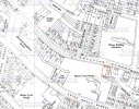
What an interesting thread. My Great grandparents and 8 of their children lived at 110a Phillips Street from 1903 and are recorded there in the 1911 census. Does anyone know why it was 110a and not just 110? Also is anyone able to locate it on a map? I can place the Talford in at 48 and count from there but would like a second opinion if possible.
Many thanks.
Many thanks.