• Welcome to this forum . We are a worldwide group with a common interest in Birmingham and its history. While here, please follow a few simple rules. We ask that you respect other members, thank those who have helped you and please keep your contributions on-topic with the thread.

    We do hope you enjoy your visit. BHF Admin Team

OLD BIRMINGHAM PHOTOS FROM STEVEBHx

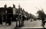
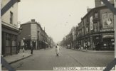
Market Hall corner of Jamaica Row and Moat Row, wholesale fish market nearest to the camera, fine ornamental windows , with metal window framing. Suited Gents with the barrow in the foreground, a nice GPO Morris van and a couple of nice mini vans. Yellow "No waiting " sign on the right and a Triangle in a circle sign in front of the market Hall.

Test420.jpg
 
This is another view of the Council house - slightly more to the right giving an idea of how the traffic moved at the end of Colmore row, one lane bending back on itself to go down New Street the other going a dog leg to pass in front of the Town hall. To the right is the start of the building of the Nat West site and associated banking offices.
I am often amazed at the amount of traffic which was a) allowed to pass one of the Cities most important buildings and b) could travel through the centre of the city.
Again I have no year but I think the Post Office Tower dates it .

Test430.jpg
 
I actually have the original for this slide, the scan was back to front so I have flipped the picture, and it is titled Ladywood Soling and Heeling, St Vincent Street, does this mean any more to anyone - St. Vincent Street I understand . An image of times gone by - washing out in the centre, clothes prop too, child running, front door open, sash windows open small scullery(?) to the side of the front door. Telephone pole throws the perspective as it seems massive and is actually behind the houses.
Test454.jpg
 
Last edited:
We are now in Corporation Street and Victoria Law Courts looking a bit more grimey than today. Interesting to see the A34 sign I presume this was the main road in those days. Not sure what was on the extreme right hand corner - neon signs for Bar & , Drag, Chi and Day, Fine selection of cars too.

Test439.jpg
 
your photos are amazing steve...so pleased that after a break you are posting a few more...thanks

lyn
Hi Lyn

thanks for the kind words, I am coming to the end of all the black and white images and colour scans - I have a coupke of hundred slides which I " lberated" to scan although some have already been seen and I will start on your negatives as well. I will not be so prolific but will try and post a steady selection of images rather than disappear for months !!

Can I also thanks all members for their additions to my posts - they all make the pictures complete .
 
We are now in Corporation Street and Victoria Law Courts looking a bit more grimey than today. Interesting to see the A34 sign I presume this was the main road in those days. Not sure what was on the extreme right hand corner - neon signs for Bar & , Drag, Chi and Day, Fine selection of cars too.

View attachment 176731
Would the neon signs be for the Dragon Chinese Restaurant?
 
steve its good to see our members working together to keep the forum interesting and lets face it the way the old birmingham is slowly being wiped away all we will have soon is photographic evidence of what it once looked like...thanks again and just post when you have the time....

lyn
 
Next we have 4 picture from the same location - unfortunately I do not know where the location is !! These are almshouse and show two view of the courtyard with residents gathered outside and the washing area in the corner. The building at the end seems to be more cummunal living where the other buildings seem to be individual properties. The third image is a close up of the image above the door ways.
The last picture shows the inside of one of the building and how sparse they look. they may also be a bit drafty looking at the curtains over the front door and the tape around the edges.

any suggestions?

Test449 1.jpgTest413 1.jpgTest447.jpg
Test314 1.jpg
 
wow steve...now where on earth are those almshouses...i would think as so many used to be back then they were just for women

lyn
 
Not sure how similar almshouses were but this picture of Dowell's Retreat, Warner St appears to have the same windows and decorations...

looks like the same place mark....i have just looked on street view and unless i have missed them it looks like they have been demolished

lyn
 
Not sure how similar almshouses were but this picture of Dowell's Retreat, Warner St appears to have the same windows and decorations...

I think that is right. the building at the end would be the chapel, and plan is as on map c1889

map c1889 showing almshouse in warner st.jpg
 
Next image is very much a city in transition, Five ways showing the start of the construction of the underpass and roundabout. It is hard to imagine that there was no roundabout there , but this was before al lot of traffic was routed around the city. There are large areas of cleared land and houses and court stretch down Broad Street. You can just make out the curve of the canal top left corner and top right I assume to be the post office parking area. I am also surprised at how many recognisable modern building arte already there.

View attachment 176471
Auchinleck House under construction 1964
 

Attachments

  • 06A2EC1A-D18A-4E24-A042-AC75B962DAB0.jpeg
    06A2EC1A-D18A-4E24-A042-AC75B962DAB0.jpeg
    899.7 KB · Views: 38
We are now in Corporation Street and Victoria Law Courts looking a bit more grimey than today. Interesting to see the A34 sign I presume this was the main road in those days. Not sure what was on the extreme right hand corner - neon signs for Bar & , Drag, Chi and Day, Fine selection of cars too.

View attachment 176731
If I remember correctly, the building to the right in the 30/60s was Yates's wine lodge. If I'm wrong it was the next building. But I'm sure it is.

Do you notice the change in driving laws the Ford parked by the crossing would not be allowed today.


Nick Phillips
 
This is another view of the Council house - slightly more to the right giving an idea of how the traffic moved at the end of Colmore row, one lane bending back on itself to go down New Street the other going a dog leg to pass in front of the Town hall. To the right is the start of the building of the Nat West site and associated banking offices.
I am often amazed at the amount of traffic which was a) allowed to pass one of the Cities most important buildings and b) could travel through the centre of the city.
Again I have no year but I think the Post Office Tower dates it .

View attachment 176722 It would be 1962/63.
Nick Phillips
 
We now have the Dog and Partridge Ashted Row, lot of things going on that you no longer see, man pushing his cart - Rag Man?, and the whole area seems ready or has been demolished. Looking right is a wasteland and the next door property is all bricked up. The pub itself is all leaded windows, the classic corner pub. Parked outside are a fine selection of vehicles, including a Co Operative lorry.

View attachment 176469
Loving this one Steve, as always many thanks. Kind regards , Sue
 
another wall this one from 1973, I have it as 329 Green Lane Bordesley, however I street viewed the address and the view is actually Charles Road. Nothing much apart from a small hoarding for Lem Sip, and the irony of the Bill posters will be prosecuted sign. I cannot imagine a hoarding so small today. Interestingly the Bill Poster sign is still there .

View attachment 176517
Green Lane Small Heath , you can see the damage on the pub following the Tornado of 1931
 

Attachments

  • 9A6A5DA4-0CB3-42AB-97CB-E8AADC0F3F01.jpeg
    9A6A5DA4-0CB3-42AB-97CB-E8AADC0F3F01.jpeg
    485.6 KB · Views: 66
This image has a lot to offer although at first view it is a clearance site, there is a gasholder in the distance, does this make it Nechells area and a large church which should be recognisable location. There is a tall old style telephone pole, traditional street light and not much else. It seems someone has removed a couple of boards from the house on the right, and note the lad dressed in shorts walking towards us, as there are no leaves on the trees we assume its winter so he must be cold. In the background children are playing on the cleared land. ( Again this seems to be a picture I recall been posted before - someones parents were married in the church ? I am sure you will let me know)

View attachment 176496
My mom and dad were married here in August 1947. Many thanks Sue
 
We now have the Dog and Partridge Ashted Row, lot of things going on that you no longer see, man pushing his cart - Rag Man?, and the whole area seems ready or has been demolished. Looking right is a wasteland and the next door property is all bricked up. The pub itself is all leaded windows, the classic corner pub. Parked outside are a fine selection of vehicles, including a Co Operative lorry.

View attachment 176469
This building is still standing and even the "Ashted Row " sign remainsAshted Row.jpg in place.
 
This building is still standing and even the "Ashted Row " sign remainsView attachment 177082 in place.
Thank you so much for this pic Jonob. I cannot believe it is still standing. As for Windsor Street South, I didn't know that it existed. I went to Windsor Street primary school. I never seem to get the time to go and visit these streets, although I am promising myself all the time. I lived in Gopsal Street, our house long gone but the Eagle and Ball pub is still there, (more happy memories but I wont go down that road, excuse the pun) restored for the Birmingham City University. Many of our members would have seen photographs of the Eagle & Ball on our wonderful forum.

Thank you again Jonob, you have made my day. I am still amazed that the building is still standing and apologies for a bit of digression.

Kind regards, Sue
 
A picture of the Rotunda from New Street Station
Source historicengland.org.uk
 

Attachments

  • 5D29ECA6-A004-45E9-A081-9C78560167D9.jpeg
    5D29ECA6-A004-45E9-A081-9C78560167D9.jpeg
    257.8 KB · Views: 33
Sherlock Sreet, look at the advertisements Bisto, Wills Gold Flake, and the lady crossing the road in her pinnie
Source historicenglan.org.uk
 

Attachments

  • B174C38C-0EF1-4700-AC8D-3FFAA75C60E0.jpeg
    B174C38C-0EF1-4700-AC8D-3FFAA75C60E0.jpeg
    318.4 KB · Views: 66
Good evening
Here are a few more picture of old Birmingham, first we have a view of the Bridge Link connecting New Street Shopping Centre and the Bull Ring area above Smalbrook Queensway. Remarkable for the lack of traffic apart from a few cars and a couple of Fleetliner busses. Interesting lampposts and the bridge which of course is no longer there.

Test309 1.jpg
 
An image which shows the two icons of Birmingham the Rotunda and the Bull from the Bull Ring, as usual I am not aware of the year although the base of the Rotunda does not have any advertisement around it. Not sure if the patterns on the Bull have any symbolism. (?)
Test308 1.jpg
 
Back
Top