BrummieGeoff
Sparkhill Lad
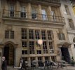
I believe the RAC sign shows an accreditation for the Woolpack Hotel.Nice photo!
I wonder what the ' Illustrated ' refered to? Man in uniform standing outside and Express Cafe next door.
Small RAC sign showing on the left - would that be an office they had?


 let it run for a while then i can more or less date it as well...if you like pm me with your guess