Laura-Jen
master brummie
Afternoon all,
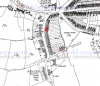
I have spent the past few months trying to find 141 Northfield Road Harborne, my grandfather was born at this address in 1930 so would love to trace it. I live locally and there doesn’t appear to be in existence anymore. I have looked at old maps and the buildings along the road on both sides don’t really appear to have changed in the last 80 years. I have found the property on the 1911 census but not where on the road it is. What I can’t find is if the road has ever been renumbered, possibly after 1930. I have counted up to 105 before Tibbats Close, I have emailed the almshouses which are relatively knew but occupy the site of previous buildings but had no response. The golf course has been there for over 100 years and cannot find any trace on maps of buildings between the almshouses and Quinton Road.
Does anyone have any resources regards possibly renumbering?
Thanks
Laura