-
Welcome to this forum . We are a worldwide group with a common interest in Birmingham and its history. While here, please follow a few simple rules. We ask that you respect other members, thank those who have helped you and please keep your contributions on-topic with the thread.
We do hope you enjoy your visit. BHF Admin Team
You are using an out of date browser. It may not display this or other websites correctly.
You should upgrade or use an alternative browser.
You should upgrade or use an alternative browser.
Great pic..I have been searching for ages for New John St West Where I grew up.. but it cannot be the Newtown Palace rear because the flats in the distance were after the junction with Summer Lane??
hi tom...photos and angles can be very deceiving...that definately is the rear of newtown palace pic house taken on the corner with new john st and newtown row as already said by moss on post 99..elkington st is in the foreground running accross..quite right about the line of 5 block of flats being after the summer lane junction but like i say photos can be deceiving and distances can look either further or closer..
all the best
lyn
Last edited:
Cheers Lyn.
I spent my very happy childhood at 2/457 New John St West- in real poverty but happy. I suppose because nobody had anything anyway so no [pressure from peers.
Elkington St.. I am sure that connected with Blews St Park
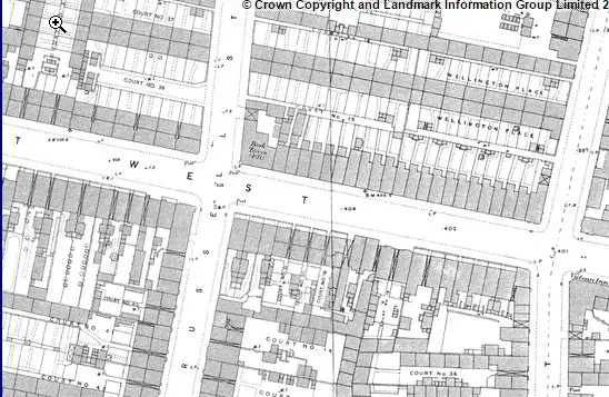
hi again tom my next mission is find more photos of njsw so keep you eyes on this thread..i am posting you this 1940s street map ...over the years i have found it so useful to find my way around the old end...looking at it i cant see a park in blews st but there is one off bracebridge st which i remember so well as my aunt lived in bracebridge and i used to go there to play in the park with my cousin jenny quite right about everyone being the same we were all in the same boat but i well remember how neighbours would help each other out in times of trouble to the extent that if they had nowt they would happily give you half of that.....hope the map goes on ok.. save it to your pc you will be able to zoom in even closer...ok thats not worked so i will upload via photo bucket...

lyn
Last edited by a moderator:
Thanks ..we called it Blews St Park.. but were obviously wrong..I loved the "old end" so much better than this material crazy money mad world
have to agree with that tom...the brum of our days has all but gone now but one thing they cant take away from us are our memories..they will stay will us forever..
not sure if you are interested in other streets apart from njsw but recently i have posted lots of new photos of farm st..little king st and frankfort st prior to demo...you will need to use the search box at the top right of the page to find the individual threads...any problems finding them just give me a shout...
all the best
lyn
Peter Brackley
proper brummie kid
Hello Tom,
Our family lived just across the road from Millmans at 4/23. Often used to get sent there on errands by my Mum. She also used to loan my sister and I out as shoppers to a couple of elderly ladies who lived in the yard in the opposite corner. When I was a kid Millmans seemed to have everything you might possibly want and all crammed into what must have been a really small space.
We lived there until about 1958 when they started to move people out of the yards. The place was still there for some time after we left but must have been demolished around 1960/61 I think. Horrible to see it all gone now and a dual carriageway in its place.
Did you used to play on the bomb peck on our side of the road I wonder? Our adventure playground in those days but hard to get on to as I remember.
Hello
I'm having a bit of a brain-ache with two addresses that are frequently popping up in my genealogy. It looks like my great grandad had two houses because they seem to be flitting back and forth.
i think it's the same address but one is a localism and the other official, wonder if anyone here knows for certain?
The addresses I have are 9 house 47 court New John Street West and the other is 9 back of 359 New John Street West.
Both were used, between 1916 and 1927...
i think the clue is in the 9 house... What do you think?
They are the same address. If you look at the electoral rolls, then court 47 comes between nos 358 and 359, meaning it was behind one or both of these houses. It is not uncommon for houses in numbered courts to also sometimes be listed as "behind...". To make it even more complicated, sometimes the courts are given names also, such as xxx Terrace, so there are three possible names.


 hi eric..i think ive posted a similar shot before but from a tatty mag and not showing the view down gks so im chuffed with it....was sent to me by carl chinn...here are another 2 just in case they have not been on before...
one is the bank tavern not sure which corner of gt russell st this was on and the other one i think we may have seen before..

Had relations living in 1843 in Hospital Street and in 1851 in NJSt. Never been able to find the building on NJSt where they lived called Cutlery Buildings. Well at least I think it was 'Cutlery' . Thanks for posting Lyn. Viv.
Sent from my iPad using Tapatalk HD
Sent from my iPad using Tapatalk HD
Thanks Mike and Lyn. The ancestors are the Adey's listed at the top on this 1851 Census extract. Maybe it's 'Cutlers Buildings'. Not sure, but definitely starts with a 'C'.Viv.

Sent from my iPad using Tapatalk HD
Sent from my iPad using Tapatalk HD
Yes Lyn, had a closer look with it magnified and I think you're right. Don't know what sort of place it was, probably not particularly great as Wm Adey (son) got 5 years hard labour for stealing lemel/gold from his employer! Families eh?! Viv.
Sent from my iPad using Tapatalk HD
Sent from my iPad using Tapatalk HD
cant find anything in the 1868 kellys viv...im not subbed to anything at the min if i was i could get up your 51 census and keep flicking the pages to see what numbers were next to that building that way we would know which end of njsw it was...naughty william lol...i think if we dig deep enough we have all got a william in the family...i know i have lol...
Thanks for trying Lyn. V.
Sent from my iPad using Tapatalk HD
Sent from my iPad using Tapatalk HD
mike you know me hopeless at maps etc but if vivs building was near to no 59 im taking a guess that it was more or less opposite to the c brandaurs pen factory building which is still there and under renovation at the min..bet i get it wrong lol
Last edited:
Right viv
Below is a map showing Cutlers Buildings in blue. coming after nos 58.59, and before no 60 there are 10 listed in the census,as Cutlers buildings. they are on the south side of the street between Summer Lane & Hospital St. The 1920 electoral roll also lists 10, but describes them as "next 59"
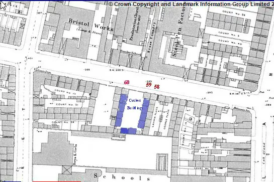
Below is a map showing Cutlers Buildings in blue. coming after nos 58.59, and before no 60 there are 10 listed in the census,as Cutlers buildings. they are on the south side of the street between Summer Lane & Hospital St. The 1920 electoral roll also lists 10, but describes them as "next 59"