www.midlandspubs.co.uk
Pub Historian
Does anybody have any old maps of the Rotton Park area - pre-OS maps, say, early 19th century? I am trying to locate Spring Grove House, once the home of the glass entrepeneur William Chance who died in 1856.
This is about the time they dismantled the place and sold off bits before redevelopment of the area.Spring Grove House. There is a mention in 1866 of Spring Grove, Icknield Street West, and Reservoir Road, opposite St. John's Church.
The position of lady wood place is given on the 1880s map,below.. Iriginally the vine was listed as being run by thomas beach, who also had a nearby nursery. He died in the early 1840s, and the pub and nursery were then run for a time by Sarah and her son John.Yes, she is listed in Icknield Street West but close to Ladywood Place which I suspect was near Ladywood Lane [later Ladywood Road]. In terms of the census she was not far from Icknield Port Road so it suggests she was in that part of the road. As I state on my web page, Monument Lane extended from Hagley Road to Ladywood Lane. Icknield Street West, along with Monument Lane, formed Monument Road around 1877, though there were trade directory listings for Monument Lane Station prior to this.

Thanks Mikejee, I hadn't got this map - are they back online now? I did clock the info on Thomas Beach. Following his death, Sarah sold off the lower part of the nursery, suggesting it was quite extensive. I had also noted the name of Beach Street and wondered if it referred to this family or the more famous industrialist. The location of Ladywood Place seems to suggest the former. Perhaps, and only conjecture on my part, that the street was laid out on laid formerly used as the nursery. Again, thanks for the map.The position of lady wood place is given on the 1880s map,below.. Iriginally the vine was listed as being run by thomas beach, who also had a nearby nursery. He died in the early 1840s, and the pub and nursery were then run for a time by Sarah and her son John.
Sorry, I forgot to add that the Vine inn sign fits in nicely with a nursery - there was also a vinery in the grounds of the aforementioned Spring Grove which wasn't far from the tavern. However, I do not know the exact location of the house. As Pedrocut posted, and I have seen the item to which he refers, this was possibly closer to St. John's Church.
Seems to fit, though I would like to see more documents or map. Your contribution of the large-scale map was very helpful. I miss these maps! I could, if I could be arsed, go to the library to try and tie it all up neatly but I find the new library pretty much unusable and don't bother going to what is essentially a coffee shop with terminals and the odd book or two. Everything else requires a booking or reservation.That seems very reasonable
I am not sure if this is of any use to you but I have been looking at this area in the context of R W Winfield. I don’t know the area at all. There are a couple of maps in it and it refers to a Kitchen Garden. I haven’t learnt how to put a link on here but the photo should give enough information to find it.Seems to fit, though I would like to see more documents or map. Your contribution of the large-scale map was very helpful. I miss these maps! I could, if I could be arsed, go to the library to try and tie it all up neatly but I find the new library pretty much unusable and don't bother going to what is essentially a coffee shop with terminals and the odd book or two. Everything else requires a booking or reservation.
It’s about proposals for land where RW Winfield had property rather than the works site. Tinpothi tinpot...i cant seem to see the report on either of your links if it concerns winfield brass that was in cambridge st on the site of the new library i would be interested to read the report as i was up there a lot during the excavations some years ago
lyn
Looks interesting but I cannot access it. It may be a restricted access site?I am not sure if this is of any use to you but I have been looking at this area in the context of R W Winfield. I don’t know the area at all. There are a couple of maps in it and it refers to a Kitchen Garden. I haven’t learnt how to put a link on here but the photo should give enough information to find it.
 www.google.com
.jpg")


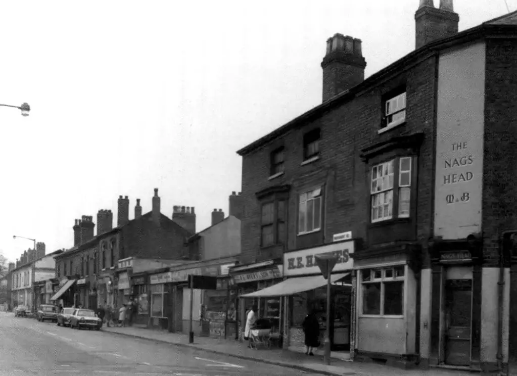
Cant be 1958 as the Triumph Herald did not come out till 1959. The Herald does not look Factory Fresh so I guess photo is 1962 ish.Hi another one of Monument Road, taken 1958
Regards stars