• Welcome to this forum . We are a worldwide group with a common interest in Birmingham and its history. While here, please follow a few simple rules. We ask that you respect other members, thank those who have helped you and please keep your contributions on-topic with the thread.

    We do hope you enjoy your visit. BHF Admin Team

Lamp Tavern Handsworth

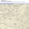
If there is a connection of Mary Birch (but of course more likely her husband James Birch) to Wyrley Birch this can be traced to Hamstead Hall - once the Manor House. Or is it just a coincidence ? Viv
 
Last edited:
Not sure if I'm read it right (post #29) is Wyrley Birch listed as Lord Lewisham or is Lord Lewisham just unnamed?

Sandwell Hall seems to have belonged to and occupied the Legge, Earls of Dartmouth from it's construction until the mid 1800s. And Viscount Lewisham was a courtesy title used by the heir to the Earldom.
 
Another update. Thanks for contributions. Keep ‘em coming! Viv.
 

Attachments

  • 41A48993-3DFC-4AA4-B575-3781E964C59C.jpeg
    41A48993-3DFC-4AA4-B575-3781E964C59C.jpeg
    459.5 KB · Views: 0
  • 638671EC-AA3A-42A8-A068-390BAD86BB4E.jpeg
    638671EC-AA3A-42A8-A068-390BAD86BB4E.jpeg
    483 KB · Views: 0
Last edited:
Yes agree, that’s confusing MWS.

He’s listed here for a gaming licence at Hamstead. Was Hamstead Hall in Sandwell ? Viv.

4C61263E-3D96-47B7-83EE-8FEBD258548D.jpeg
 
  • Appreciate
Reactions: MWS
Wyrley Birch appears to have been born in 1782ish and married in 1804. Some children were baptised at Handsworth but those after 1813 were baptised in Norfolk where he died in 1866. He doesn't seem to have had a brother called James so if related it's more distant than that.
 
It goes way back, The manor seems to have passed from the Wyrley’s to the Birches in the 18th century according to Bill Dargue’s site:

In 1538 William Wyrley held freehold of the manor of Handsworth his chief mansion called Wyrleys or Hamstead Hall and all lands belonging to it, as well as other properties called Holford and Milwards, Hamstead Mill and Holford Mill, a fishery on the River Tame, and other lands besides.

William Wyrley's hall was the original manor house of Handsworth, but it is not known when the Wyrleys first came into possession of the house or estates. Certainly the family is known from at least the 13th century holding land in Hamstead, Handsworth, Little Barr and Perry. The hall and its estates along with half the manor of Perry and the manor of Handsworth passed to the Wyrleys' descendants, the Birches in the 18th century.
 
To add to Vivs information list, here are the landlords listed in directories I have access to (remembering that this is publication date of directory, not survey date):
From Directories
1850 Robert Beeson, (blacksmith)
1851-1862 Elizabeth Beeson
1867-1868 Edward Such
1870-1876 Alfred Farrell (rose engine turner)
1878-1882 Alfred Thomas Hale
1882 Mrs Sarah Hale
1884- 1890 Harry Howell
1892-1899 Mrs Mary A. Wilkinson
1900-1908 William Butler & Co
1910-1912 Harry Bushall
1913-1915 Eric Roland Bushall
1921 Frederick Edward Walker
1923 Isaac Moore
1932- 1933 Harold Shinn
1936-1937 William Bradbury
1938 Not listed
 
Thanks Mike. Very helpful. Interesting that Robert Beeson was the blacksmith of the smithy on the site. There would certainly have been enough coaching trade in the mid-1800s along the Hamstead Road for shoeing horses and handling coaches. (There were also stables and a coach house on site).

The absence of a listing in 1938 suggests this might have been the point at which the licence was transferred to Church Hill/Hill House/Endwood.

I believe the very earliest the Air Training Corps would have been organised to make use of the site would have been 1939 but only by ATC officers (later years for cadets). So perhaps the Lamp site was unused for just a few years.

Does anyone have any info about Handsworth ATC and their organisation building up to WW2 ? Viv
 
Last edited:
In the latter part of the 18th century the house of Mr Birch seems to have seen a lot of activity in terms of moves to address the social issues of Handsworth. Mr James Birch played host to meetings for the Handsworth Association; a group seeking to ensure the apprehension and prosecution of felons. Annual meetings were held and, by 1791, had the support of many local inhabitants, including James Birch and George Birch. By 1799 Mary Birch became a member of the Association - she’s described as Widow Birch, so presumably she was James Birch’s widow.

From these can we deduce the house was, up until this time just that, a house ? There’s no mention of ‘tavern’. Although in earlier posts there’s reference in 1791 to ‘the sign of the Lamp’, maybe this was because the house was near the one and only lamp in the road. By 1811 we know for certain it had become a tavern.
Viv.

2971351E-19E6-4410-93F5-6DD817069EFE.jpegFDDF1F22-99C7-45B7-BD47-D3FAAB85104E.jpegD4761C1E-708A-44DE-ADF5-FC0E6EBE3895.jpeg
Source: British Newspaper Archive
 
Last edited:
The “House of James Birch” was also host to a meeting in 1791 looking into the conduct of alehouse keepers and victuallers which would assist in the issuing/renewal of licences. The proposal was to confine these to providing necessary accommodation for travellers. The request for the meeting came from the rector of the nearby Handsworth Church.

Interestingly, James Birch’s house would have been a perfect location on the turnpike road for a roadside coaching inn run by a respected and responsible landlord. Viv.

D426BA58-B8EA-4700-A3F9-CD22B9FF8A7B.jpeg
Source: British Newspaper Archive
 
Last edited:
Turning back to the site of the Lamp/Handsworth Tavern, I believe the original house was probably once a house of note in the Handsworth area. I think it only became a tavern at the very end of the 18th century/early 1800s. Perhaps this happened after James Birch passed away in 1799 ? Perhaps Mary moved elsewhere and the premises were let - when William Woodward took it over in 1813. When did Mary Birch pass away ?

If we look at the 1912 map posted by MWS in post #3 (thank you) it’s obvious the muddle of buildings we see by that time weren’t part of a planned footprint of a reasonably sized mid-18th century house (supposedly built c1750). I don’t think it was any old house to be host to such important meetings like the Handsworth Association, Turnpike Trustees etc. Possibly some of the areas such as the smithy and stables were from an earlier phase. But the tavern certainly doesn’t fit with a house built in the mid-18th century. I also wonder if there was any relationship with Church Hill/Hill House/Endwood house ? Church Hill House has a very long history. Could the house of the Lamp/Tavern have originally been a large farm ? Just tossing around ideas at this stage.

Do we have any other earlier maps that show the site and it’s buildings please? MWS’s map is attached below for easy reference.

Viv.
 

Attachments

  • AC2F55ED-A0CA-4D40-9927-2F285BCA690B.jpeg
    AC2F55ED-A0CA-4D40-9927-2F285BCA690B.jpeg
    333.4 KB · Views: 16
Last edited:
This map is from 1884 but not as good. All the buildings appear to be there, though the Lamp Tavern seems to label a building that is no longer there in 1912 and what is later labelled the Lamp Hotel is unlabelled...

0 - Lamp Tavern.jpg
 
Very confusing MWS. Comparing the three maps, it really is difficult to see what’s been going over on at the site (red dots). I can see that the site must have been developed after 1834 - at this time there appears to be two distinct buildings, although I the map isn't detailed enough. By the 1880s there seems to be a row of stables perhaps (?) surrounding a central courtyard. Maybe the demand for the smithy and stables (due to increased horse and carriage traffic along the Hamstead Road) has required this.

As MWS pointed out, by 1912 the little group of buildings labelled as the Lamp Tavern (on the 1880s map - above the number ‘392’) have disappeared and the site had been given the new name of the Lamp Hotel The structure along the north side seems to have been opened up. Maybe these changes were all part of changing/modernising the main building ? All very confusing.

Also attaching below the two definitions for Hotel and tavern from comparewords. Not sure if that is much help either except to say I think it’s significant it had changed from being a tavern to an hotel by 1912. Viv.
6854B109-E5D0-416C-8E8C-2BE273504EB5.jpeg31FC8BB5-72C0-4B20-9ED1-E888B76393D0.jpeg
D3891E6D-1EA4-4517-B8E5-4FA50C936113.jpeg
 
Last edited:
Richard Oliver , an accepted expert on OS maps, in his book "Ordnance survey maps , a concise guide for historians" states that where a Hotel is labelled as such they are "specifically designed to provide accommodation for motorists and their vehicles". The motorist bit would not apply at this date, but I think it reasonable to asssume that accommodation would be the primary aim. Unfortunately, he does not mention taverns, though inns should provide accommodation and refreshment, and public houses do not provide accommodation
 
This map is from 1902 and doesn't have as many labels. However, assuming it's not because of the O of Handsworth then the Lamp Tavern has gone by this date. Also Handsworth Wood Station is now labelled (wasn't in 1884) so I wonder if maybe this is the reason for the changes of the Lamp Tavern/Hotel...

0 - Lamp.jpg
 
There seem to have been a number of realignments in this area as the main entrance to the Endwood on NW side suggests- also the cut to the graveyard. There are a lot of old walls in the area too.
 

Attachments

  • 522D4A92-F24C-44D4-9E11-CDDDF1B48564.jpeg
    522D4A92-F24C-44D4-9E11-CDDDF1B48564.jpeg
    887.5 KB · Views: 7
MWS
According to the Warwickshire railways site , Handsworth Wood station was opened in 1896, so would not have existed in 1884
 
  • Appreciate
Reactions: MWS
I’ve spent a lot of time looking at this 1795 painting by the Rev Stebbing Shaw and I wondered if the building to the right of St Mary’s Church would be on the site we’re discussing. Could the one next to the white dot be any part of the Birch’s house/site ? Viv.

A59A177A-5781-4200-82EB-F573AA45D708.jpeg2E803953-CE6E-46F4-B3E0-3CB3D6BEE6A6.jpeg
 

Attachments

  • A865B228-8A41-40D6-9813-685B1D1582EA.jpeg
    A865B228-8A41-40D6-9813-685B1D1582EA.jpeg
    122.5 KB · Views: 5
This map seems to show a small building opposite the rectory
 

Attachments

  • 6D68C6EE-8E2C-4BD6-8C5A-F7AA3F1BFF4F.jpeg
    6D68C6EE-8E2C-4BD6-8C5A-F7AA3F1BFF4F.jpeg
    569.9 KB · Views: 12
Tinpot, yes I think that building could well be the first building to the right in Stebbing Scott’s painting of 1795 ! If so that’s great. It must mean the building (chimney) behind with the white dot on the enlarged image in post #52 is most likely the Birch’s house. Viv.
 
Last edited:
thanks viv great information...somewhere on the forum is a photo of the cattle pound but im not sure if it had mr george standing outside of it..be great if any of mr georges rellies saw this photo of him

lyn
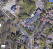
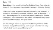
hi viv just flicking through my handsworth books looking for anymore info than we already have and i have found the photo i was thinking of...taken in 1908 of the cattle pound but this one has 2 young lads standing outside..the other photo from the book show a close up of mr george also taken in 1908..

there is also one of the lamp inn at 300 church hill and we already have this one..as said i dont think the info that goes with the photo will tell us anything new but just in case it says..
PHOTO TAKEN 1937 IT WAS DESCRIBED IN A BILL OFF SALE IN 1819 AS MOST DESIRABLY SITUATED FOR BUSINESS..THE FRONTAGE SEEMS TO HAVE BEEN GIVEN A NEW FROTAGE IN 1870..CLOSED 1937

lyn
 
That’s great thanks Lyn. The info about the frontage and the 1937date of closure is new info. The sale of the house must be the same sale as that in post #22 - the auction date being 1820 in that advert, Thanks for that, all very helpful.

I shall update the timeline soon to take account of the additional info from Lyn’s post #55 and Mikes post #36 info. Viv.
 
Forgot to say Lyn about the Pound photos. Be worth putting them on the Handsworth thread and/or the Handsworth Pound thread as the great great grandchild (member Alimichele) of Mr George is a member of this forum. Viv.
 
Mike(Jee) posted this on the Handsworth Pound Hamstead Road thread in response to a query about the location of Mr Isaac George’s house (blacksmith of the marked Smithy). It’s located next to the LampTavern buildings. The row of structures running north to south must have been a series of about 5 cottages. Would these be farm labourers cottages ? Viv.

F6BF4ADE-0C4A-4DA9-AD7F-FDF96D2FF986.jpeg
 
Oldmohawk posted this 1920 aerial view on the Handsworth Pound Hamstead Road thread. I’ve rotated the view and annotated it to show the main landmarks. The Lamp Tavern (gabled building) seems to be directly next to/alongside another building/buildings - ie building(s) to the right of the Lamp. Viv.

7C93E6A1-B03D-4C6B-B9D2-0797B337ED51.jpeg
 
Last edited:
To avoid repeating the timeline as in previous posts, I’ve now turned it into the document below. It brings together all the information found about the Tavern. Thanks all who’ve helped. Viv.
 

Attachments

  • 7CAD546C-72DD-4661-AC77-4F8E1071D69A.jpeg
    7CAD546C-72DD-4661-AC77-4F8E1071D69A.jpeg
    655.1 KB · Views: 8
  • 6C037759-B65E-437E-9D0C-5D7485B2BFA5.jpeg
    6C037759-B65E-437E-9D0C-5D7485B2BFA5.jpeg
    231.4 KB · Views: 6
Last edited:
Back
Top