• Welcome to this forum . We are a worldwide group with a common interest in Birmingham and its history. While here, please follow a few simple rules. We ask that you respect other members, thank those who have helped you and please keep your contributions on-topic with the thread.

    We do hope you enjoy your visit. BHF Admin Team
  • HI folks the server that hosts the site completely died including the Hdd's and backups.
    Luckily i create an offsite backup once a week! this has now been restored so we have lost a few days posts.
    im still fixing things at the moment so bear with me and im still working on all images 90% are fine the others im working on now
    we are now using a backup solution

Help to ID the location of a photo of Prince George Inn

Mrs Bear 51

master brummie
Hello all,
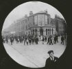
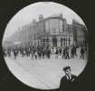
I have been passed a number of pictures from a family who have no known living relatives. Amongst them is this one - a street scene including the Prince George Inn.
The family had links to Birmingham, certainly Handsworth, Sparkhill and Aston and I wondered anyone could say if it was a Birmingham pub or not.
I realise its a long shot, but you lot are all so good with this kind of stuff, I thought I'd see if you could help.
Thank youprescott st and crabtree rd prince george inn.jpg
 
Last edited by a moderator:
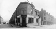
There was a Prince George on the corner of Crabtree Road and Prescot st. (No 72 Crabtree road)
 
Last edited:
what a great photo mrs bear well done mike for sorting out the location...i had rellies in prescott st so no doubt they used the prince george..think the area comes under brookfields...

i wonder what the occasion was..cant quite read the banners


lyn
 
Last edited:
Here it is in later years, and later still it seems to have been a corner shop

View attachment 176084
Wowzers - I think it is the same one, obviously a slightly different angle, and it looks like it has had some 'modernisation' done since my picture was taken, but from the design etc, I'd say it was the same place.
When you say Crabtree Road is it the one that runs off Clissold Street?
With the demolition of houses all over the city and the loss of some road names, I can't quite pinpint Crabtree at Prescot Street!
Thank you for your fantastic knowldge - I knew I'd come to the right place.
 
what a great photo mrs bear well done mike for sorting out the location...i had rellies in prescott st so no doubt they used the prince george..think the area comes under brookfields...

i wonder what the occasion was..cant quite read the banners


lyn
Is there any way to get the picture on one of the other threads for lost pubs etc, please.
When I look at this thread, all I see is my jpg, not very enticing/exciting to say the least.
 
What a great picture.... but I am so bewildered by how clean the streets are !
hi tony the streets tended to be cleaner then than some streets are today....back in the day folk could not afford to waste anything and most took pride in what they had...they even went out with a broom and swept the streets themselves

mrs bear i have tried to change the format of the way you have posted your photograph on post 1 so that i can post it on here but alas my computer skills are not good enough so maybe other members maybe able to help with that

lyn
 
great thanks mark...mrs bear i have now deleted the photo you posted on post 1 and replaced it with the visible one..if you save it you should be able to post it on the lost pubs thread

lyn
 
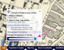
yes it is the same pub...here is a map showing the corner of prescott st and crabtree road...if you move the blue dot the map will fade to show you what is there now...i will see if i can get your photo onto the lost pubs thread...click on link below

lyn

Lyn great photo. I remember the area well, and still find my self having a walk in the area in my head I remember the way it was in the 50/60s
I wish I understood " if you move the blue dot the map will fade....." I do find computer speak hard work.
But its great the hard work that you all put into 'History Forum', thank you.

Nick Phillips.
 
All you have to do is put your mouse pointer on the blue dot, click and hold down your left mouse button and move it to the left.
 
All you have to do is put your mouse pointer on the blue dot, click and hold down your left mouse button and move it to the left.
Every thing easy when you know how, " on the blue dot"?.
I notice a lot of very young children who are not yet talking in push chairs but are able to operate "I Pads".
I have no idea at all. ITS AN AGE THING.
But thanks for trying.

Nick Phillips
 
Every thing easy when you know how, " on the blue dot"?.
I notice a lot of very young children who are not yet talking in push chairs but are able to operate "I Pads".
I have no idea at all. ITS AN AGE THING.
But thanks for trying.

Nick Phillips

Hi

If you click on the blue link in the post from from Astoness, where it says "Explore georeferenced maps - Map images - National Library of Scotland," a map will open up showing the area in which you are interested.

In the bottom-left corner is a white square headed "Choose an historic map overlay." At the bottom of that square is a blue spot at one end of a horizontal track, and if you put your computer/mouse cursor over that spot and hold the left mouse button down, you can move the blue spot along that slider track. This makes the map turn gradually transparent, and it then reveals an aerial photo of the exact same location so that you can see what it looks like today compared to the date the map was created ... which for example will let you see where roads and streets may have disappeared, new ones created, open-space green areas created, things like that.

I hope that helps, I find that seeing these then-and-now comparisons can be very interesting.

H.
Hi H ( would rather use a name ).

H, when I followed your instructions it was easy. At first I could not see "the blue dot". and it made no sense at all.

Once again thanks for your effort, and putting up with an old fool like myself.

Nick Phillips
 
Back
Top