• Welcome to this forum . We are a worldwide group with a common interest in Birmingham and its history. While here, please follow a few simple rules. We ask that you respect other members, thank those who have helped you and please keep your contributions on-topic with the thread.

    We do hope you enjoy your visit. BHF Admin Team

Great Barr Cottage

oldMohawk

gone but not forgotten
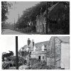
Three young girls stand in this road as the photographer takes his photo. A caption on the photo (postcard) says it is in Gt Barr but having looked at it for quite a few years I have no idea where it is and I know Great Barr.
The road ends at an angled junction with another road which has fields on its far side maybe a park. The road has 10 bar telegraph poles carrying trunk telephone wires which usually radiated outwards from the city centre. Behind the cottage is a glimpse of a 'church like' building.
Does anyone know where it is ? Now Solved thanks to a photo in post#192 ...
Confirmed that it is solved with appearance of photo in post#237 ....

:)
GtBarrmysterypic.jpg
 
Last edited:
no idea phil but i bet its changed now...i will have a look in a book i have of that area but it does not ring any bells .....what does that triangular sign mean

lyn
 
Hi Lyn, it looks like an old road sign warning but they usually had a notice under the triangle. As the sign is on the other side of the road presumably it is warning about something behind the photographer. I've been looking at the old maps to see if I can find a junction like it.
phil
 
Searched, but can't find any sign pre 1960 that is just a triangle without another plate with message below.
 
Yes it definitely does not seem to be a proper road sign but for some reason someone put it there.
As far as I remember and after looking at old pics, not many roads had telephone poles carrying trunk lines. One notable example was the Kingstanding Rd which had poles carrying lines to the Chester Rd. Those poles however were 14 bar poles so not the ones in the photo. The Walsall Road had telephone poles but with few bars and wires and were probably going to the Great Barr Exchange. The road has a wide footpath and kerb on one side.
 
I wonder if that's a farm worker's cottage ? If it is a chapel or a church building to the side of the cottage, there must be other cottages there too. I'm thinking this might be a hamlet in the Great Barr area. It certainly looks like rural Great Barr/Kingstanding pre-1930s. The clothes look about 1920s. Shall have a think. A nice photo, hope we can pinpoint it. Viv.
 
If you put road signs in the UK into Google and pick up the Wikipedia entry, you will discover that there were four basic signs in the early days, the triangle was one of them and the article indicates that although the sign was a warning of a hazard, there was not necessarily any additional information of what the hazard might be.
Bob
 
im going to take a stab at booths lane but no proof as yet
lyn
Had a look round your Booths Lane suggestion Lyn and there is a possibility as shown on the map below. It could be that the road is not a tee junction but the Queslett Rd to the right curving round into the road in the pic with Booths Lane on the left. We probably need to investigate further, there appears to be a building named Brook Cottage (on the map) opposite the row of cottages in the pic.
download (1).jpg
 
ooh thats a teaser pedro...looking at astburys cottage newton road dated 1930 on the link you posted there looks to be a telegraph pole outside..the cottage and the one in phils photo are similar as well... terrain and buildings change over time so bit more investigating to

lyn
 
I don't think it is Asbury's Cottage having looked at how it is positioned on the Newton Rd. I've looked for info on that Brook Cottage (possibly opposite the row of cottages) and it is mentioned ref THE GREAT BARR HALL ESTATE, STAFFORDSHIRE. The cottage has since been demolished.
 
Had a look at the Asbury building alongside the unknown cottage. Yes, similarities but there would have been major demolition for the the cottage to have lost parts at either end. The lower windows and door lintels don't quite match up and the telegraph pole is too close to the building. So agree Lyn, probably not a match. Viv
 

Attachments

  • image.jpeg
    image.jpeg
    69.4 KB · Views: 20
OldM suggests a church-like building close by. It looks to me like a methodist Chapel, and if so it should be able to be located?
 
In the second map in #2411 there's a "Ch" - chapel perhaps ? It's just below Old Hall Farm and almost next to " Great Barr". It's close to the junction of roads and a lane. Magnified below. Viv.

.image.jpeg
 
Last edited:
phil looking at your map 2410 which i turned around..it cant be brook cottage as its on the wrong side of the road...it would have to be on the right to be that close to the junction/turn off....i think..
 
Are there records mapping telegraph poles? If so what was the route across Great Barr ? Viv.
 
viv ive just gone through my gt barr book..los of old pics showing old cottages and buildings in country lanes and roads and most of them have got those telegraph poles in them...that photos of phils could be anywhere in gt barr:eek:
 
Last edited:
The church like building looks like the old chapel that used to be on Shady Lane near Oscott School lane.
 
hi moss strange you should say that there is a photo of all saints church shady lane in the book i have here..the only thing is the photo also shows the old school house next to the church...having said that we could check out an old map of shady lane..bit late now will have a look tomorrow
lyn
 
Last edited:
In the second map in #2411 there's a "Ch" - chapel perhaps ? It's just below Old Hall Farm and almost next to " Great Barr". It's close to the junction of roads and a lane. Magnified below. Viv.

.View attachment 121596

just going back to this post viv and just to confirm...the CH must stand for chapel as the road is now called chapel lane..comes out onto the birmingham road...

moss ive looked at the overlay map and i do not think its shady lane...

lyn
 
Last edited:
Hi Lyn, I only mentioned Brook Cottage because it was named on a map, and it would have been on the opposite side of the road to the row of cottages. I've rotated the map and marked the row of cottages pink, and Brook Cottage green. The problem with the location is no chapel on the map and also what appears to be a gateway leading to a bridge over the brook in the field.
Incidently, that brook flows through the Beeches Estate into Perry Barr park.
I've also rotated the 1945 aerial view with shading and is that a building next to the cottages ?
Phil
map.jpg

Rotated 1945 aerial view ... cottage row shaded pink
Capture2.JPG
 
morning phil...it could be a building....dont forget although it could be we dont know for certain that it is a church or chapel in your photo......oh i do wish i could find your photo in one of my books showing the location...i have a day off today so i think i will plough through some...by the way where did you get the photo from

lyn
 
Morning Lyn,
I have no FB account but occasionally I have a look at it to see my pics which have been copied from the BHF to FB and I have no problem with that. However, if they are going to copy my pics I will copy theirs .... it came from FB ... :)
 
totally agree with you phil exchange is no robbery and of course it came with no caption:(...this is most frustrating but i think we should plod on a while yet..keeps us out of trouble..:D

lyn
 
Last edited:
Back
Top