• Welcome to this forum . We are a worldwide group with a common interest in Birmingham and its history. While here, please follow a few simple rules. We ask that you respect other members, thank those who have helped you and please keep your contributions on-topic with the thread.

    We do hope you enjoy your visit. BHF Admin Team

Gibbett Hill - New Oscott

Dashers

master brummie
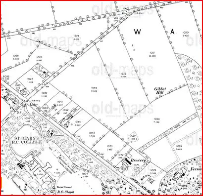
I have seen mention to Gibett Hill on a few threads on the forum but I haven't seen a 'definitive' location?

Does anyone have this marked on a map or written down?

I've seen mention of Hall's Garden Centre or the New Oscott Village but is this speculation?

I live opposite the college and the land behind us rises before it falls down to Boldmere high street, I would imagine that would have been a significant hill in days gone by. Could it have been up there?

There are tales of a brewery on that hill, but I'm not so sure as I have seen nothing of this anywhere.

It would be interesting to ascertain where the 'gallows' was and whether I should start digging in the garden
 
Last edited:
Re: Gibett Hill - New Oscott

Hi Dashers!

The usually reliable Bill Dargue gives a location for Gibbet Hill near New Oscott.

This is very interesting to me as I used to live nearby in Darnick Road in the early 1960s.
 
Re: Gibett Hill - New Oscott

The 1884 OS map shows Gibbet Hill

map_c_1884_showing_gibbets_hill.JPG
 
Re: Gibett Hill - New Oscott

Hi Dashers!

The usually reliable Bill Dargue gives a location for Gibbet Hill near New Oscott.

This is very interesting to me as I used to live nearby in Darnick Road in the early 1960s.
Thylacine that is interesting as my aunt, uncle and cousin lived in Darnick Road from the 40' to late 60's we visited them often as my Dad could drive straight through the park in those days from Four Oaks gate to Wyndley gate. The family name was Hook my uncle was the postmaster at Sutton post office.
 
Re: Gibett Hill - New Oscott

Thanks chaps, looks like its bang on top of the highest point (as the name suggests) probably under the houses (although the old 'spinney' reamins in that vacinity)

On a side note, that brewery is road side whereas I was led to believe that too was on the hill, but roughly scaling it to a modern map puts it where the garden centre is (oscott tavern / place2b / taylors etc)
 
Re: Gibett Hill - New Oscott

Hi Wendy!

I don't remember the Hook family, but that's because I was pre-occupied with Meccano, chemistry sets and buses! I probably used to deliver their newspapers though. Also spent a lot of time in Sutton Park which I remember fondly.
 
Re: Gibett Hill - New Oscott

You may have remembered my cousin Pat who was very pretty and rode a Lambretta. I was quite a bit younger than her and would look on in awe as to me she looked like a film star lol.
 
Re: Gibett Hill - New Oscott

Dashers, there are a few other references to Gibbet Hill on the Forum:
There appears to be some uncertainty as to the exact location. I think that Antrobus Road as shown in the OS map posted by Mike is most probable. This is also where Bill Dargue says it was, though the "red arrow" on his map doesn't point there. As you said, the highest point is most likely, as the point of displaying the felon's corpse on the gibbet was as a warning to others.

Wendy, surely I must have noticed your glamorous cousin on her motor scooter. But I just don't remember. It is half a century ago after all (well that's my excuse anyway!). I'm reminded of Audrey Hepburn in the movie Roman Holiday (1953).
 
This OS 1834 map shows Gibbett Hill to the east of Beggars Bush, near the Old Chester Road, just below the words 'The Coldfield'. Viv.

ImageUploadedByTapatalk1329233881.629913.jpg

560791fc-80e1-0e8c.jpg
 
Re: Gibett Hill - New Oscott

Nan lived in Harcourt Road, just off Court Lane and she used to refer to Antrobus Road as the place to swing from, she lived there from 1945,moving in when they came back from Coalville where grandad was involved in war work.
Sue
 
When researching the history of this area, I remember reading that the part of the Hall's Garden centre shop, which fronts Chester Road is what remains of a cottage which was known as Cook's farm. Looking at old maps, I came to the conclusion that Gibbet Hill was behind the New Oscott Tavern, but the old maps are hard to relate to modern ones. I know that Boldmere Lake used to stand where Fosseway Drive is and that the Greyhound pub was once a coaching inn used by travellers on the Chester Road, the present building replacing an older timber-framed one. I also remember reading that one of the highwaymen hung on Gibbet Hill was called Jordan and he was buried at the junction of Chester Road and what is now College Road, and the local area was known as Jordan's Grave for a long time after this and his ghost was reported as late as the 1950s. Once reading the Birmingham Gazette from 1799, there was a report of a Mr. Hunt being held up by a highwayman, on the London and Chester Road as he was crossing the Coldfield, who took his pocket watch and money. However, when Mr. Hunt asked for the return of some of his money, the highwayman did so. If I remember correctly, he returned to him five shillings. The Coldfield was well-known for highwaymen.
 
Beverleigh what an interesting piece. I am facinated as I grew up in Sutton there were many tales of highwaymen from times past.
 
Here is an extract from the book by William Fowler, A History of Erdington written in 1885...

"A little further to the north, and only a few yards from the Chester Road, very near the site of the gasworks at Oscot College, was within my recollection to have seen, in the ditch that then formed the parish and county boundary, a heap of stones that marked what was known as Jordan's Grave, the last resting place perhaps of some poor wayfarer who nobody owned, and to whom no parish would condescend to give a decent burial. it was obviously the grave of some person who came to an untimely end in the immediate neighbourhood.

I believe no tradition remains of its history but the position of Jordan's Grave is indicated in the old county maps as far back as at least the 18C.

It was the custom in former days to hang murderers and highwaymen as near as possible to the scene of their crimes, and to leave the biddies hanging on the gallows, and I very well remember in my early days seeing the stump of a gibett remaining on the high ground between Boldmere Church and the Beggar's Bush, still known as Gibbet Hill. The Gibbet was I believe erected in 1729 in honour of the murderer of a silk dyer from London, who was robbed in the immediate neighbourhood..."

Regards Peter
 
Last edited:
Back
Top