Richard Dye
master brummie
Thank you! It was an interesting read, very advanced even in today’s world.No, afraid not Richard. Did not even know it was disbanded shortly after.
Thank you! It was an interesting read, very advanced even in today’s world.No, afraid not Richard. Did not even know it was disbanded shortly after.
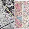
The Gas Street Map is not the most accurate as no mention is made of the canal basin or the early tramway. But yes these works were the reason for the name of the street, yet as stated it did have a previous purpose before it gained the name.
But why is Berkley Street so named?


Wonderful picture with an extraordinary depth of field (at least I think so)!Last picture for tonight is not Gas Street - when I looked at the canals forum I didn't know where to start so I will post it here and someone else can make the choice of where to move it !!
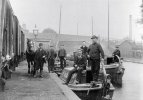
The post It on the back says Lifford Lane Canal early 1900's, there is so much to see, wagons on the left, horse, gas lamp, and then the people involved in the loading and unloading of the cargo as well as steering the boats to their destination.
View attachment 160230
It helps that the original photo I scanned was around 7 x5 inches which helps!!Wonderful picture with an extraordinary depth of field (at least I think so)!
 birminghamhistory.co.uk
Those are impressive 'Derbies' they are both wearing, but reminiscent of another forum, all but one of them wearing headgear. Do you think the guy with the suit and shirt and tie is the 'gaffer'. What a pity 'suit's' leg covers the boat's company name. But what a wonderful age defining picture, it certainly says this is how it was.Last picture for tonight is not Gas Street - when I looked at the canals forum I didn't know where to start so I will post it here and someone else can make the choice of where to move it !!
The post It on the back says Lifford Lane Canal early 1900's, there is so much to see, wagons on the left, horse, gas lamp, and then the people involved in the loading and unloading of the cargo as well as steering the boats to their destination.
View attachment 160230
I believe the butty at the back is named Bordesley but I cannot make out the name on the MR boat. Someone will know!Horses on the canals
A few more canal/horse based images that I have collected over the years trawling the web. I have no other information with them other than I set out below, The first one is at Lifford Lane, Cotteridge, the second just states Birmingham canal, the third is the Navigation Offices on Paradise...birminghamhistory.co.uk
There are two butties visible, maybe more. They would require a horse to pull them. The man with the horse maybe a No.1, owner of boats who employed men to crew them. The name visible on one boat is that, I believe, of the Midland Railway.
A post on Canalworld.net suggests that the nearer butty is 'Victoria'I believe the butty at the back is named Bordesley but I cannot make out the name on the MR boat. Someone will know!
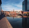
The Church of the Messiah over the canal was demolished in 1978 so pre-dates this photo.I have got a new printer/ scanner cable and while I was testing it I ran a few canal pictures through the scanner, first is the other Gas Street picture I talked about as usual there is no date but I am guessing at mid sixties? Everywhere looking a bit run down, but the backdrop remains the same.
View attachment 160228
