edit there is another thread here about the hospital during the period 1936 - 1950
 birminghamhistory.co.uk
------
hi folk cant find a thread for this at the moment...i need some help please in finding out about the old erdington almshouses/workhouse which it may have originally have been..ive been told the address is the gardens fentham road erdington and is at the back of the old highcroft hospital also been told that there used to be an old well on the site..any info..photos or old maps would be very much appreciated...
thanks
edit found it on streetview

 www.google.com
lyn
www.google.com
lyn
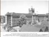
Highcroft Hall Erdington circa 1936 to 1950
Trying to find the history of what happened to Highcroft Hall and its demise or name change etc
------
hi folk cant find a thread for this at the moment...i need some help please in finding out about the old erdington almshouses/workhouse which it may have originally have been..ive been told the address is the gardens fentham road erdington and is at the back of the old highcroft hospital also been told that there used to be an old well on the site..any info..photos or old maps would be very much appreciated...
thanks
edit found it on streetview
Google Maps
Find local businesses, view maps and get driving directions in Google Maps.
www.google.com
Last edited by a moderator: