Like many others I get confused about the precise location of Digbeth and Deritend.It would help us all if we could be more precise about the two locations. So please put your comments here so that we can arrive at a definition of these two separate areas. Street names would help. Many thanks. Viv.
-
Welcome to this forum . We are a worldwide group with a common interest in Birmingham and its history. While here, please follow a few simple rules. We ask that you respect other members, thank those who have helped you and please keep your contributions on-topic with the thread.
We do hope you enjoy your visit. BHF Admin Team -
HI folks the server that hosts the site completely died including the Hdd's and backups.
Luckily i create an offsite backup once a week! this has now been restored so we have lost a few days posts.
im still fixing things at the moment so bear with me and im still working on all images 90% are fine the others im working on now
we are now using a backup solution
You are using an out of date browser. It may not display this or other websites correctly.
You should upgrade or use an alternative browser.
You should upgrade or use an alternative browser.
Defining Digbeth and Deritend
- Thread starter Vivienne14
- Start date
www.midlandspubs.co.uk
Pub Historian
Hi Viv
I have included a paragraph on my page which tries to sort this issue....
"Many people seem to get a little mixed up or confused with Deritend High Street. Understandable in some respects as the road from the Bull Ring to Camp Hill seems like one long seamless thoroughfare. However, the area of Digbeth ended at the River Rea and once formed the boundary between Birmingham and Deritend and Bordesley in Aston. Having said that, Deritend High Street officially started at Milk Street on the north side so there are some properties on the west side of the river that belong to the thoroughfare. And rather than finish on a street junction, the north side of Deritend High Street finished a few doors away from Adderley Street. Across the road the south side started or finished at Court No.13 next to the King's Head, the latter being in Bordesley High Street. The boundary between Deritend High Street and Digbeth was a few doors from Court No.1, almost directly opposite Milk Street so, again, there are some buildings included on the western side of the river."
Of course, this refers to the main road, not the 'loose' areas of Digbeth and Deritend. These extended north and south by a few streets. For example, the area of Deritend extended to Cheapside. These areas are very hard to define, though old rate books make it clearer. So, for example, Bradford Street started in town, became part of the Digbeth area, then Deritend once it crossed river, and finally in Bordesley up the top end.
Great, thanks all. So would anyone like to have a go at a visual like an annotated map. ? Think that would be really, really helpful. I’m thinking of something that simply marks the two boundaries. At least that way we can have a clearer picture of the two areas, which I’m sure others would appreciate.
Viv.
Viv.
www.midlandspubs.co.uk
Pub Historian
Great, thanks all. So would anyone like to have a go at a visual like an annotated map. ? Think that would be really, really helpful. I’m thinking of something that simply marks the two boundaries. At least that way we can have a clearer picture of the two areas, which I’m sure others would appreciate.
Viv.
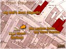
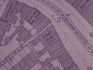
Viv, I have already started on that. It is on my High Street Deritend page but here is a map extract showing No.1 ...
Attachments
www.midlandspubs.co.uk
Pub Historian
www.midlandspubs.co.uk
Pub Historian
www.midlandspubs.co.uk
Pub Historian
The final boundary was Milk Street so, there we have it, no confusion now!!
www.midlandspubs.co.uk
Pub Historian
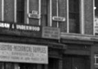
By the way, just down from the Rainbow PH, there used to be a sign marking the beginning of Bordesley. The refurbished buildings have survived but the sign has gone .....
There used to be a sign for both Deritend and Bordesley on that row - this pic is from a distance but you can just about make them out ...
Attachments
www.midlandspubs.co.uk
Pub Historian
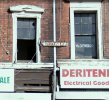
and, just to lump it all together [with the exception of the corner building on Rea Street] this is Deritend High Street ....

That’s helpful. They should have left those signs up Kieran, probably would’ve helped to avoid some of the confusion.
One other question, where did ‘Digbeth’ start ? Viv.
One other question, where did ‘Digbeth’ start ? Viv.
www.midlandspubs.co.uk
Pub Historian
That’s helpful. They should have left those signs up Kieran, probably would’ve helped to avoid some of the confusion.
One other question, where did ‘Digbeth’ start ? Viv.
They probably ended up on e-bay. Some of the old street signs fetch a few hundred quid!!
www.midlandspubs.co.uk
Pub Historian
That’s helpful. They should have left those signs up Kieran, probably would’ve helped to avoid some of the confusion.
One other question, where did ‘Digbeth’ start ? Viv.
Tut tut Viv, you are not reading my pages :
History and Information on Digbeth in Birmingham
History and Information on Digbeth in Birmingham in Warwickshire with Photographs, Pubs, Licensees, Local Folklore, Census Data, Newspaper Articles and Genealogy Connections
Ha ha ha. There’s a hell of a lot of info on there ! Done my homework now, so is the answer Park Street? (noting the upper section was formerly Cock Street before Digbeth absorbed it). Viv.
I want a Geographers sticker now Kieran pls! And thanks. Viv.
www.midlandspubs.co.uk
Pub Historian
I want a Geographers sticker now Kieran pls! And thanks. Viv.
Well, I did teach A-Level Geography in part of my varied career/journey!
williamjukes
master brummie
On the south side, the border was the entry to Court 13, the King's Head being the first building of High Street Bordesley.
May I ask what number (on High Street) would the Kings Head public house have been.
William.
Lady Penelope
master brummie
This is what Carl Chinn had to say.
AS THE hit song goes: "Let's hear it for New York". Well, locally what about: "Let's hear it for Deritend"? Why? Because Deritend is one of the oldest and most important place names in the history of Birmingham and yet it seems doomed to disappear from the 21st century city.
By contrast the name of Digbeth has waxed to such an extent that it is no longer just a street between High Street Deritend and the Bull Ring. Now it is also used to define a large area.
To the north of Digbeth the street, the new district of Digbeth seems to encompass all those streets from Park Street almost up to Camp Hill; whilst to the south it embraces all those streets below the Bull Ring markets and again almost up to Camp Hill. In reality many of these streets actually lie in Deritend.
This shrinking of Deritend and the expansion of Digbeth has led to confusions and inaccuracies in official communications, on radio stations, in newspapers and on a plethora of websites. Many addresses are given as on Digbeth High Street. There is no such place and never has been such a place. Other addresses are given as in Digbeth when they are not.
The Digbeth Campus of South Birmingham College, the Irish Centre and the Custard Factory are not in Digbeth. All three are in Deritend.
Does all this matter given popular usage? It does if we care about our historical place names and the people who lived in them. And it does matter for all those Brummies who grew up in Deritend and now watch unhappily as their district is pushed from history.
For hundreds of years Deritend belonged to the parish of Aston and was separated from Birmingham by the River Rea. This ran below what is now Rea Street, at the top of which (by the later Middle Ages) it split into two channels. One then went along what is now Milk Street, whilst the other went down what became Floodgate Street. Both later joined up. The land in between the two channels, which is now occupied by South Birmingham College, was known as Deritend Island.
Deritend has been tightly bound with Birmingham for centuries. Located distantly from Aston Parish Church it was pulled into a deeper relationship with its nearer neighbour after Birmingham's lord gained the right to have a market in 1166.
Soon after, Deritend was probably granted to the de Berminghams by their overlords, the Paganells of Dudley.
Recently the assiduous researcher George Demidowicz made a discovery that has transformed our understanding of medieval Birmingham. He came across the rentals for the borough of Birmingham in 1296. These indicated a number of streets, one of which was Deregatestret. Mentioned again in a deed from 1319, this Deer Gate Street became Deer-gate End in a document from 1381 and hence Deritend.
The spelling of Deregatestret solves the debate about the meaning of Deritend. Some historians had argued that the "der" element was derived from the Welsh "dwr" meaning water, whilst the rest of the name is from "yetend" - signifying gate end. However, the 1296 entry strengthens the case put forward by Joseph Toulmin, a 19th century expert on Birmingham. In his opinion Deritend is from "der-yat-end" and means the deer gate end. End was used to signify an outlying hamlet or the edge of a settlement.
In this case it indicated that Deritend was a suburb of Birmingham. As for the deer gate, this would have led into Over Park, recalled in Park Street, where the lords of Birmingham kept deer.
Digbeth was not mentioned as such in the 1296 Borough Rentals, although there is a record of "versus aquam". Meaning "towards the water", this was probably the route that went down to the Rea and which became Digbeth.
This documentary evidence for Deritend is bolstered by discoveries made over the last few years in archaeological excavations. They revealed signs of houses on Deritend Island in the 1200s. It appears that they were abandoned later in that century, but pottery from the same site indicated renewed activity here in the early 16th century. They also uncovered evidence of a tannery and of metal working.
The importance of Deritend both to the urbanisation and industrialisation of Birmingham is further emphasised by its distinction as the first of Birmingham's streets to be described. In about 1540 the Tudor traveller John Leland visited the town, coming down Camp Hill through "as pretty a street or ever I entrd". This was Deritend High Street, or "Dirtey" as Leland called it. In it dwelt smiths and cutlers, and it boasted both a chapel (St John's) and a mansion house of timber (the Old Crown pub).
This High Street became the centre of a workingclass township that included most of modern Highgate.
Dominated by factories, backto-back houses and railway lines, its people were pushed out in the post-war redevelopment of Birmingham.
Despite this loss, many fine buildings remain as does the late 18th and early 19th century street pattern. So "Let's hear it for Deritend" and call it by its correct name.
I've been researching my ancestors, the Geasts, for many years and they are shown on a map from Paul Leslie Lines' book
book
'Birmingham A History in Maps'. (Sorry about the scan, I haven't worked out how to crop them yet). Their address was variously given as 'Deritend Island' and 'Deritend Bridge' and you can see the name 'Geast' on the property. They were there from the early 1400's to about 1820 when the bridge was rebuilt.

AS THE hit song goes: "Let's hear it for New York". Well, locally what about: "Let's hear it for Deritend"? Why? Because Deritend is one of the oldest and most important place names in the history of Birmingham and yet it seems doomed to disappear from the 21st century city.
By contrast the name of Digbeth has waxed to such an extent that it is no longer just a street between High Street Deritend and the Bull Ring. Now it is also used to define a large area.
To the north of Digbeth the street, the new district of Digbeth seems to encompass all those streets from Park Street almost up to Camp Hill; whilst to the south it embraces all those streets below the Bull Ring markets and again almost up to Camp Hill. In reality many of these streets actually lie in Deritend.
This shrinking of Deritend and the expansion of Digbeth has led to confusions and inaccuracies in official communications, on radio stations, in newspapers and on a plethora of websites. Many addresses are given as on Digbeth High Street. There is no such place and never has been such a place. Other addresses are given as in Digbeth when they are not.
The Digbeth Campus of South Birmingham College, the Irish Centre and the Custard Factory are not in Digbeth. All three are in Deritend.
Does all this matter given popular usage? It does if we care about our historical place names and the people who lived in them. And it does matter for all those Brummies who grew up in Deritend and now watch unhappily as their district is pushed from history.
For hundreds of years Deritend belonged to the parish of Aston and was separated from Birmingham by the River Rea. This ran below what is now Rea Street, at the top of which (by the later Middle Ages) it split into two channels. One then went along what is now Milk Street, whilst the other went down what became Floodgate Street. Both later joined up. The land in between the two channels, which is now occupied by South Birmingham College, was known as Deritend Island.
Deritend has been tightly bound with Birmingham for centuries. Located distantly from Aston Parish Church it was pulled into a deeper relationship with its nearer neighbour after Birmingham's lord gained the right to have a market in 1166.
Soon after, Deritend was probably granted to the de Berminghams by their overlords, the Paganells of Dudley.
Recently the assiduous researcher George Demidowicz made a discovery that has transformed our understanding of medieval Birmingham. He came across the rentals for the borough of Birmingham in 1296. These indicated a number of streets, one of which was Deregatestret. Mentioned again in a deed from 1319, this Deer Gate Street became Deer-gate End in a document from 1381 and hence Deritend.
The spelling of Deregatestret solves the debate about the meaning of Deritend. Some historians had argued that the "der" element was derived from the Welsh "dwr" meaning water, whilst the rest of the name is from "yetend" - signifying gate end. However, the 1296 entry strengthens the case put forward by Joseph Toulmin, a 19th century expert on Birmingham. In his opinion Deritend is from "der-yat-end" and means the deer gate end. End was used to signify an outlying hamlet or the edge of a settlement.
In this case it indicated that Deritend was a suburb of Birmingham. As for the deer gate, this would have led into Over Park, recalled in Park Street, where the lords of Birmingham kept deer.
Digbeth was not mentioned as such in the 1296 Borough Rentals, although there is a record of "versus aquam". Meaning "towards the water", this was probably the route that went down to the Rea and which became Digbeth.
This documentary evidence for Deritend is bolstered by discoveries made over the last few years in archaeological excavations. They revealed signs of houses on Deritend Island in the 1200s. It appears that they were abandoned later in that century, but pottery from the same site indicated renewed activity here in the early 16th century. They also uncovered evidence of a tannery and of metal working.
The importance of Deritend both to the urbanisation and industrialisation of Birmingham is further emphasised by its distinction as the first of Birmingham's streets to be described. In about 1540 the Tudor traveller John Leland visited the town, coming down Camp Hill through "as pretty a street or ever I entrd". This was Deritend High Street, or "Dirtey" as Leland called it. In it dwelt smiths and cutlers, and it boasted both a chapel (St John's) and a mansion house of timber (the Old Crown pub).
This High Street became the centre of a workingclass township that included most of modern Highgate.
Dominated by factories, backto-back houses and railway lines, its people were pushed out in the post-war redevelopment of Birmingham.
Despite this loss, many fine buildings remain as does the late 18th and early 19th century street pattern. So "Let's hear it for Deritend" and call it by its correct name.
I've been researching my ancestors, the Geasts, for many years and they are shown on a map from Paul Leslie Lines'
book'Birmingham A History in Maps'. (Sorry about the scan, I haven't worked out how to crop them yet). Their address was variously given as 'Deritend Island' and 'Deritend Bridge' and you can see the name 'Geast' on the property. They were there from the early 1400's to about 1820 when the bridge was rebuilt.


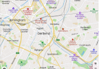
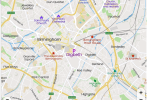
Leaving Bordesley High Street aside, this is how I understand Digbeth and Deritend in relation to the main road. Digbeth is red, Deritend is orange. Effectively they ‘share’ the road between Milk Street and Deritend Bridge ie: Digbeth takes the south side of the road, while Deritend takes the north side of the road at that section of the road. Is that correct ? Just trying to find a simple way of expressing this so that it can be explained on the relevant threads. Viv.
Digbeth section (red line) Park Street to Deritend Bridge

Deritend section (orange line) Milk Street to Adderley Street

Digbeth section (red line) Park Street to Deritend Bridge
Deritend section (orange line) Milk Street to Adderley Street
Lady Penelope
master brummie
Thanks Mike, much clearer on your map.
I would suggest using the official Royal Mail addresses to determine the precise boundaries between roads. After all the Royal Mail is the ultimate authority on addresses in the UK.
For example recently on another site some people were disputing whether the Old Crown was in Digbeth of High Street Deritend. A search of the Royal Mail website gave:
Old Crown
188 High Street
Deritend
BIRMINGHAM
B12 0LD
Question answered")
(Cute choice for the last three characters of the postcode).
For example recently on another site some people were disputing whether the Old Crown was in Digbeth of High Street Deritend. A search of the Royal Mail website gave:
Old Crown
188 High Street
Deritend
BIRMINGHAM
B12 0LD
Question answered
(Cute choice for the last three characters of the postcode).
Last edited:
www.midlandspubs.co.uk
Pub Historian
Leaving Bordesley High Street aside, this is how I understand Digbeth and Deritend in relation to the main road. Digbeth is red, Deritend is orange. Effectively they ‘share’ the road between Milk Street and Deritend Bridge ie: Digbeth takes the south side of the road, while Deritend takes the north side of the road at that section of the road. Is that correct ? Just trying to find a simple way of expressing this so that it can be explained on the relevant threads. Viv.
Digbeth section (red line) Park Street to Deritend Bridge
View attachment 165769
Deritend section (orange line) Milk Street to Adderley Street
View attachment 165770
Sorry, but for accuracy the red line should end at the first building on the east side of Rea Street. No.73
The orange line should not extend to Adderley Street but finishes at the old post office - opposite the court marked on the map you have used.
A bit more accurate, using my 2 year old granddaughter’s crayons ! Viv
DIGBETH

DERITEND
DIGBETH
DERITEND
www.midlandspubs.co.uk
Pub Historian
A bit more accurate, using my 2 year old granddaughter’s crayons ! Viv
Crayon envy ... I haven't crayoned for decades!