Follow along with the video below to see how to install our site as a web app on your home screen.
Note: This feature may not be available in some browsers.
Welcome to this forum . We are a worldwide group with a common interest in Birmingham and its history.
While here, please follow a few simple rules. We ask that you respect other members, thank those who have helped you and please keep your contributions on-topic with the thread.
Growing up around Bordesley Green, I can remember a road called Coronation Road, that ran parallel to Bordesley Green Road. However, I cannot see any map showing Coronation Road, could anyone help please.
I can't see anything, nothing really seems to run parallel to it. Cherrywood Road bends and then does sort of. There's a short road called Crown Road the other way.
Hi MWS,
Coronation Road is not the road name, it is Carnarvon Road.
so right place, wrong name. I apologize if I caused you any inconvenience.
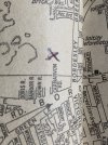
As per the attached street map, it was a few hundred yards from Crown Road, and ran a short distance parallel to Bordesley Green Road. i lived in Prince Albert Street, only a few hundred yards away from Carnarvon Road, but have no recollection of that name or ever seeing a road there. A mystery for me !
In this case it is about dates. the Street does not appear in Kellys till the 1962 edition (see below), and all the 1950s surveys for birmingham were carried before 1955. The Kellys says it was at no 70. so below is a map showing where it would be in red on the 1950s map.