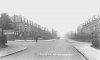
This one is labelled Chester Road Erdington. Completely baffled by this and have no idea of where in Erdington it could be. There's a pub to the left. No date given. Viv.

This one is labelled Chester Road Erdington. Completely baffled by this and have no idea of where in Erdington it could be. There's a pub to the left. No date given. Viv.
View attachment 113572
It looks like the bridge at Chester Road station.is that some sort of bridge in the distance or are my eyes deceiving me
I thought that when I looked at it under the glass and blown up particularly with the drop down and rise up after the bridge. Could the big ivy covered building on the left hand side be what became Anstey College? Just a wild thought for all you experts and map owners, could the road on the left be Boldmere Road and opposite it Gravelly Lane? Finally what is that about to pass under the bridge? Unfortunately all the figures are to Indistinct to give any date indications.It looks like the bridge at Chester Road station.
It goes under the railway at Chester Road station, over the railway at Castle Bromwich, over the Birmingham and Fazeley canal at Tyburn and also over the River Tame, the only other bridge in Erdington is the M6 and I think that this picture comes from before the time of motorways. There are railway bridges out through Streetly and Brownhills.Never seen this photo before. It does look like a bridge, I think Chester road crosses a canal, railway and the river Tame though Erdington.

Please tell me that those are not early wheelie bins by the far hedge/fence!!!! Of course it could be Birmingham leading the way in the world.An enlarged pic of the corner building ... shows the stepped front ... it does not look like a pub.
View attachment 113578
A map 1892-1905 shows the step on the building, the open space, and the ivy covered house.
View attachment 113579
Wow you lot have been busy while I've been distracted by other things today! I really didn't believe this was Erdington. Thought maybe it was an Erdington somewhere else (don't even know if there is an Erdington elsewhere). Thank you all so much. A very interesting journey on this one. Viv.
Viv, I re-read this thread and realised that I said it was the Bell & Cuckoo on the left. 5 years down the line and I'm putting my mistake right. The property on the left was known as 'The White House' and was never a pub as someone pointed out. The Bell & Cuckoo would have been on the right-hand corner of the picture and would have been long gone by the time this photo was taken.This one is labelled Chester Road Erdington. Completely baffled by this and have no idea of where in Erdington it could be. There's a pub to the left. No date given. Viv.
View attachment 113572
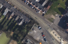
Well that's changed a lot since 1958. Star Cars are on the left. The rest include several Indian restaurants. a Chinese one another one yet to be worked out where the chip shop used to be. Could really do with Yenton Modes now that Millarde's, on the Birmingham Road, has gone.