• Welcome to this forum . We are a worldwide group with a common interest in Birmingham and its history. While here, please follow a few simple rules. We ask that you respect other members, thank those who have helped you and please keep your contributions on-topic with the thread.

    We do hope you enjoy your visit. BHF Admin Team

Canals of Birmingham

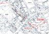
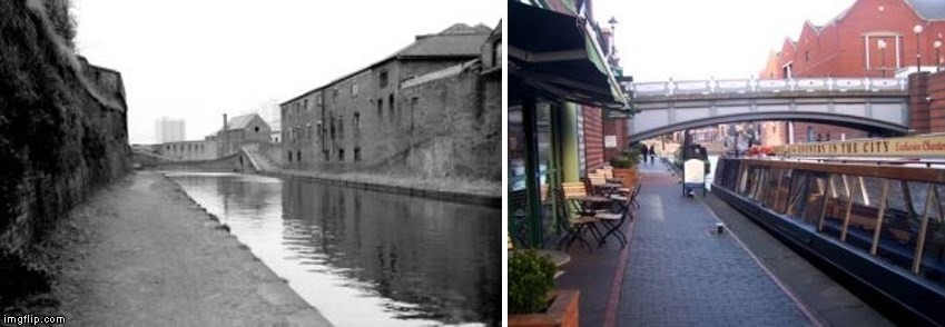
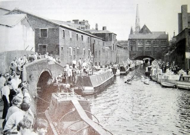
Although there is now a footbridge from the towpath to the Worcester Bar, that is a modern addition although built in a style appropriate to the age of the canals, There was a basin on the other side of Gas Street signified by a hump in the road. The basin is the bottle shape bottom centre of Mike's map in the post above.

WOW This is my 2000th post on the forum
 
ell re your question on post 927 the photo posted by barr beacon on post 922 which is a great photo looks like the same view as the photo you posted on post 920

lyn
 
Gas St basin (1).jpg That view in #922 does not look right to me, I spent many hours in the '80s painting that view numerous times (and sold them all), #920 looks more like how I remember it, apart from the modernization on the right. Eric
 
View attachment 121837 That view in #922 does not look right to me, I spent many hours in the '80s painting that view numerous times (and sold them all), #920 looks more like how I remember it, apart from the modernization on the right. Eric

Hi Eric, Your painting shown in #933 is a view as mikejees arrow in #930,

the view in#922 is a view from the Old Turn/NIA junction or Malt House Pub at the top of the Bham-Fazeley, it has been incorectly identified! ...Sorry Barr_Beacon!
 
Last edited:
crikey i also thought the photo on post 922 was gas st basin looking towards broad st....so what church is that we see in the distance..

lyn
 
crikey i also thought the photo on post 922 was gas st basin looking towards broad st....so what church is that we see in the distance..

lyn

The very same, see mikejees map #930 - we're looking at Broad St tunnel from both ends!
 
I've taken some new photos at Gas Street Basin - will upload later (to my Flickr). I'm thinking that the bridge you go up near one of the Gas Street exits might be it, as there is a bit of water near the ITV News Central studios.

Preview on here for now.

Gas Street Basin 04012018.jpg
 
pic on #92o and my painting on #933 are different to pic #922, the building over the canal is not compatible nor are the buildings on the left. Eric
 
Before I went over this footbridge again, noticed a sign dated 1995.

Photo from 2013.


Although when I saw this in 2012, it was dated 1988.

 
Of my older photos, this is the closest I think I've got of that old bridge (now blocked off on the Gas Street side).

May 2016 - between Canalside Cafe and the Tap & Spile.


In this 2010 view of ITV Central from Gas Street you can see a section of canal.

 
Another look at The Canal House.


I saw this plaque that I've not noticed before.

Cochrane & Co
Woodside Iron Works Dudley Worcestershire 1859

 
I get the feeling that there is still some confusion over these various canal views in/near Gas St basin.
Hopefully this 'little' map will clarify. #920 is a much foreshortened view of Erics painting #933 (note the window configuration over the tunnel portal) One of the #921 photos is foreshortened, too, but are similar views. The church is sat between Broad St and the clothing factory, so is shown in both 'old' views but from opposite sides! View attachment 121846
 

Attachments

  • BHF Jan 2018002.jpg
    BHF Jan 2018002.jpg
    2.3 MB · Views: 14
Last edited:
225wwx.jpg

225wzl.jpg

https://normanfield.com/wp/index.php/brindley-place-then-and-now-the-netherton-tunnel/

I feel honour bound to find the orientation of this photograph and have discovered some interesting information. The key to the photograph in the original canal festival photograph I posted is the small bridge on the left. In the 'modern' photographs it is located on the right (under the house with the round window) as the viewer is looking towards Arena Birmingham (originally known as The National Indoor Arena) and The Old Turn Junction. The author of the link I posted says...

"It (the small bridge) marks the origin of the Birmingham & Fazeley canal which goes off to the right & down the Farmer’s Bridge locks."

For more information about the history of The Old Turn Junction, I have included the following link...

https://en.wikipedia.org/wiki/Old_Turn_Junction

So as other posters have said about the original photograph I posted, it's not Gas St Basin; the picture was taken from the north west side of Broad St looking in the direction of what is now The Mail Box.
 
Last edited:
If the photograph (Post 922 and repeated in 947) is correctly dated to 1960 and I believe it is the gathering there may well have been boats and their crews going or returning from a boating festival held that year in Stoke-on-Trent.
There had been others at Stourbridge in 1962 and Stratford-upon-Avon in 1964 but they are mostly colour documented.
 
Barr Beacon, thanks for solving that, it had me confused. Eric

I was so excited at discovering the 'original' photograph (#922) that I accepted the accompanying caption without question. Hopefully I've learned my lesson. Having said that, I found out a few things I didn't know.
 
Last edited:
Honduras Wharf was part of the old Summer Lane Power Station, it is where the barges used to pull in off the canal to off load coal for the generators. When I worked at Midlands Electricity Board (and subsequent Companies following privatisation) it had long since been filled in and used as a car park/cable yard and an area for the Company training school. MEB had its Birmingham Area offices overlooking it. The att. picture shows the Wharf and surrounding buildings. The wharf is the small area between the 12 chimneys stacks and the canalSummer Lane Power Station.jpg
 
Excellent photo, not seen that view before. Were the 12 chimneys stacks cooling towers?
 
Morturn, in answer to your question, yes the stacks were cooling towers and constructed of wood. Some other info that you may find interesting is that construction of the station was started in 1906 and completed in 1913. Apparently on the opposite side of the canal was a timber merchants called Cartwrights, complaints were made that the steam from the cooling towers was preventing the timber from seasoning properly and in some cases ruining it altogether. It was also not uncommon for the lower end of Snow Hill and Summer Lane to be damp from the steam produced.
 
Reddi, thank you for that, would the square chimney also be a cooling tower too? Do you know anything about the method of generation, turbines or steam engines etc.

It seems a shame to me that such a building has gone without trace or a record
 
Morturn, not to sure about the square chimney. Some information can be found on the following site though: https:/gracesguide.co.uk/Summer_Lane_Station_Birmingham
Some of the original buildings are still in existence, although not many I must admit, Western Power Distribution operate a substation on the site and until recently a depot. When I worked at the site (1980s/90s) my Manager (Bob Taylor) did write a short book on the history of the site, I did have a copy which I loaned out but unfortunately never got back, whether it is still available I cannot say.
 
Morturn, in answer to your question, yes the stacks were cooling towers and constructed of wood. Some other info that you may find interesting is that construction of the station was started in 1906 and completed in 1913. Apparently on the opposite side of the canal was a timber merchants called Cartwrights, complaints were made that the steam from the cooling towers was preventing the timber from seasoning properly and in some cases ruining it altogether. It was also not uncommon for the lower end of Snow Hill and Summer Lane to be damp from the steam produced.

Interesting that there was still a timber merchant nearby, considering the name Honduras Wharf may have been due to the import of logwood and mahogany from Honduras before 1840. (See post 915)
 
The old brick Constitution Hill Bridge during demolition for the new dual carriageway above. They're using a floating platform formed by two boats during demolition. Viv.

image.jpeg
 
Do any of Ell's photos in #908 show Honduras Wharf please ? Viv.

Of the modern Honduras Wharf, I saw it from Little Shadwell Street (from the back - the other side of the canal)


The front view on Summer Lane.


There is little to see while walking up the towpath from Cliveland Street to Clive Passage (Old Snow Hill exit).

Photo below from late December 2017. Note that the towpath goes up slightly near the Clive Passage exit.


February 2017 view towards the Barker Bridge from Lancaster Street.

 
Back
Top