Hi Judy. No, unfortunately I've never seen a section showing the lower numbers. Surely there must be one? Seems odd to have recorded just half of the street. I believe this belonged to Mr Suffield, and I would have expected, as his property was in the lower section of Bull Street, to have seen his buildings included in this or on an additional drawing. But will keep my eyes peeled for it. Viv.
-
Welcome to this forum . We are a worldwide group with a common interest in Birmingham and its history. While here, please follow a few simple rules. We ask that you respect other members, thank those who have helped you and please keep your contributions on-topic with the thread.
We do hope you enjoy your visit. BHF Admin Team
You are using an out of date browser. It may not display this or other websites correctly.
You should upgrade or use an alternative browser.
You should upgrade or use an alternative browser.
Bull Street
- Thread starter Astoness
- Start date
Seems that during the 1791 riots in Birmingham, the Quaker Meeting House almost came under attack :
"The crowd then moved on to the Quaker meeting-house, until someone yelled that the Quakers "never trouble themselves with anything, neither on one side nor the other" and convinced them instead to attack the New Meeting chapel, where Priestley presided as minister". (Extract from Wikipedia).
Viv.
"The crowd then moved on to the Quaker meeting-house, until someone yelled that the Quakers "never trouble themselves with anything, neither on one side nor the other" and convinced them instead to attack the New Meeting chapel, where Priestley presided as minister". (Extract from Wikipedia).
Viv.
My search for a drawing of the 1703 Quaker Meeting House in Bull Street has finally paid off. Here's a drawing of it from 1823. I'm now wondering what the buildings are to either side. Am I right in thinking Bull Street is to the far right? Viv.

ellbrown
ell brown on Flickr
You can see on Google Maps Bull Street
that the Quaker's Meeting House is in a courtyard surrounded by 1 Colmore Square and The Minories.
that the Quaker's Meeting House is in a courtyard surrounded by 1 Colmore Square and The Minories.
Thanks Ell, be interesting to be able to position the 1703 Meeting House on today's map as some of the 1703 building was actually on Bull Street, not set back as the present day Meeting House (built 1933) is positioned on your Google map link. Viv.
Re-reading Edwards's recollections in post 139, it describes the building as a long barn-like building, standing lengthways to Bull Street with no windows on that side. So Bull Street must have run behind the building in the drawing in post # 164. Viv.
Hi Judy. No, unfortunately I've never seen a section showing the lower numbers. Surely there must be one? Seems odd to have recorded just half of the street. I believe this belonged to Mr Suffield, and I would have expected, as his property was in the lower section of Bull Street, to have seen his buildings included in this or on an additional drawing. But will keep my eyes peeled for it. Viv.
Just realised that Suffields IS on the drawing, doh! But even worse, I'd always looked at this drawing as being a section of both sides of Bull Street. Only now do I realise that it's just one side of Bull Street. Is it just me? Probably, yes! So now I'm looking out for a drawing of the other side of Bull Street - makes it less likely I think. Viv.
brumgum
Proud to be a Brummie!
I just spotted on Ebay this promissary halfpenny token of 1792 for No 29 Bull Street - Donald & Co, stocking manufacturers. I'm intrigued. Did most shops trade like this?View attachment 85502View attachment 85503
They have some in our museum exhibition, Birmingham it's history it's people..
https://www.flickr.com/photos/birminghammag/7982465252/in/set-72157631526384218
Re post#164 by Viv, The barn like structure is on the left of the picture and Bull St would be to the right. All can be seen in plan view on the 1890 OS and hopefully the map is included. The frontal building in your posted picture is in plan view just to the left of HO in meeting house on the map. The picture is looking towards Corporation Street. Well done and I am sure Mike will be able to add more.
It may seem labourious but trying to iron out these seemingly minor details is so important...to me anyway
https://www.british-history.ac.uk/m...d=10098&ox=1857&oy=1072&zm=1&czm=1&x=247&y=15
It may seem labourious but trying to iron out these seemingly minor details is so important...to me anyway
https://www.british-history.ac.uk/m...d=10098&ox=1857&oy=1072&zm=1&czm=1&x=247&y=15
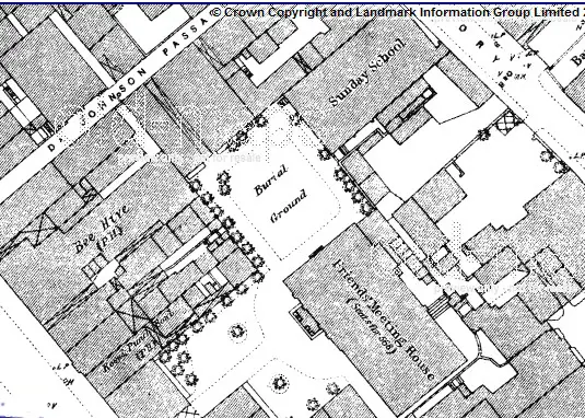
I think Rupert's anomalies suggestion is correct. The British History map is dated 1890, so would the building shown on it be the 1856 version of the Meeting House? The 1856 House was supposed to have re-placed the 1703 one (the 1856 building was enlarged a few times but then replaced in 1856). The one shown in the map looks quite some way back off Bull Street. The outline of the building on the 1890 map could, I suppose, be similar to the 1703 structure (as I don't think we [yet] have a picture/photo of the later 1856 building). But if Edwards in his 'Recollections' was correct, part of the older 1703 building was sitting along Bull Street. (However, being re-collections written in the 1870s about his memories of the 1840s, they may not have been 100% accurate of course). Apologies if I've got the wrong end of the stick here. Viv.
P.S. Interesting that Dr. Johnson Passage is on the 1890 map. This is now, I think, the access to the present Meeting House (i.e the 1933 building). Seem to remember Ell posted some modern day photos of the entrance/passageway.
P.S. Interesting that Dr. Johnson Passage is on the 1890 map. This is now, I think, the access to the present Meeting House (i.e the 1933 building). Seem to remember Ell posted some modern day photos of the entrance/passageway.
Phil
Gone, but not forgotten.
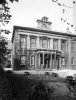
What I think you are seeing is the building on Harrison's Corner at the top of Snow Hill before the building line on Bull Street altered just compare it with this later photo, of course the angle is greatly altered. The older Meeting House that was demolished in 1931 could not be mistaken for the object building as it was of a vastly different structure.
Attachments
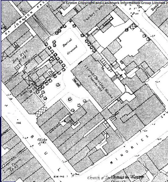
The accompanying photos' one repeated show what may be a tower on a building in the old square pre. latter day Lewis's. Look at the right side of the roof on Viv's post and look also at the tower in the Old Square. The 1890 OS shows a garden in the courtyard behind buildings on Bull St. Now if the house was built in that courtyard facing Bull St. with the Barn Like meeting house behind it, (maybe just see it on left side of house) then the tower top just visible would be in about the right location I think. Surely too much of a co-incidence to be wrong. The house does not seem present on the 1890 survey though and as said before...does not look Quakerish.
Ah, maybe that house is indeed there and was the one time Meeting House printed on the map...looks or not...it seems to have the extension to the right side and behind, down the left side passageway, may be the school on the 1890 OS. So the protrusion out front was the porch. And in front of that the garden, also shown on the map.
The camera taking the picture seems to have been in the shade which would be the case with the afternoon sun on the buildings in Bull St. behind the camera, but a shaft of light over the roofs is still illuminating the house. Even the bushes in front of the sunday school as shown on the 1890 OS can be seen in the photo. This house was always in the courtyard behind the Bull Street fronting houses and the garden would never have been seen by the passer by. This would have been the premisses demolished in the 1930s.
So perhaps the ref to 'a barn like structure' was about the previous building.
Attachments
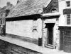
Pretty certain the 'barn-like structure' refers to the 1703 building. According to Selgin's 'A Ramble 'Round Old Birmingham', he states the windows on the road side of the building were bricked over by the 'broad brims' (i.e. the Quakers who wore broad brim hats):
"Across from Cadbury's stands the Quaker Meeting House, which isn't much to look at since the broad-brims bricked over most of the street-side windows some years back to keep out traffic noise. It was here that the Friends disowned gun maker and Lunar Society member Samuel Galton in 1796 for "fabricating instruments for the destruction of mankind"
The windows certainly seem to have been bricked up in Phil's second photo post #177. Viv.
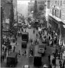
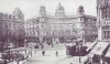
A view of Bull Street in about 1912 looking towards Lewis's. Dr. Johnson Passage must have been very close by on the left of the photo. Viv.

Shortie
master brummie
I remember it, Viv, it was only very small, and if I remember rightly, it was still there, with the nameplate still intact, when the new square was built in the 1960's. I have a book which calls it Dr Johnson Passage, but I am sure the sign said Dr Johnson's Passage which I am sure caused at least a couple of people to smirk over the years. Somone may have adulterated the sign. I remember my mother speaking about this place, although I do not have a clue as to why she should - my only thoughts is that it was probably a short cut that she had used, perhaps between bus routes when she was young.
Last edited:
Behind the buildings on the immediate left on this last photo was the Quaker meeting house with it's pillard portico and garden's...we would never have seen it even if alive then. Strange situation for a building...no street frontage and completely surrounded even when just built probably. The house photo is the same year about as this one and Lewis's is the earlier building that co-incided with the Berlin House. Dr. Johnson passage was further out to the left and may have been a quick link to the Upper Priory. The present plain building with parking lot, said to be the Quaker Meeting house is down the Dr. Johnson Passage...might be worth a trip to proove that...but I think that there is a new meeting house about where the old one was...closer to the Minories, that seems to be available for rental use possibly.
It looks like the one down the passage would have been built on the old Quaker cemetry, which was off to the left rear of the Pillard portico house and next to the sunday school.
The dome top left of the last photo is a similar dome to the one that can be seen above the Meeting House, but not that one. It would have been in the curve of the Old Square.
Hi Rupert and Shortie. I remember the passageway, but don't remember the building as such, so it must have been tucked just out of sight along the passageway, or maybe it just didn't grab your attention. I know Lewis's wanted the land it stands on, but nothing ever seems to have materialised. Didn't realise there might be access through there, I'd have used it if I'd known.
I've searched around to see what connection Dr. Johnson had with the Meeting House. But can't find any specific and direct link. I know he worked on the Birmingham Journal with Thomas Warren and he married a Birmingham woman, but what's the Quaker link? Is it his anti-slavery views? I don't think he was a Quaker himself. Maybe there never was a direct link with the Meeting House. Perhaps they just named the passageway after him. Viv.
I've searched around to see what connection Dr. Johnson had with the Meeting House. But can't find any specific and direct link. I know he worked on the Birmingham Journal with Thomas Warren and he married a Birmingham woman, but what's the Quaker link? Is it his anti-slavery views? I don't think he was a Quaker himself. Maybe there never was a direct link with the Meeting House. Perhaps they just named the passageway after him. Viv.
There are Simpson fishmongers at No 6 Bull Street on 1851 Census, so I'm hopeful that my No 7 Bull Street could be either side or opposite. According to my ancestor's sale of stock advert, No 7 was "seventh house from the High Street on the right hand side". Is this part of Bull Street still there (hope that fishmongers sign has not been destroyed)? Nickie
Think I've found a photo which shows #7 Bull Street. Simpsons, the fishmonger, is just in the photo on the right. I've enlarged that section too. The photo is from 1928 and also shows the street decorations for Birmingham's centenary celebrations. The building next along from Simpson's looks earlier than the one posted in #123 earlier on this thread. Viv.
 Bull Street 1928
 Close up of #6 Simpsons on right-hand edge of photo
Shortie
master brummie
Viv, Samuel Johnson went to Birmingham very frequently, his wife Tetty was a Birmingham widow. Johnson used to stay at the house of Dr Hector, which was around the site of Johnson Passage. I have read his biography by Christopher Hibbert but the above is the only bits I can remember about his times in Birmingham. Remember he was born in Lichfield, which was (in those days) easy walking distance from Birmingham. I think he had quite a few dealings in Birmingham and some may have been on behalf of his father, a bookseller, but I also might be getting him mixed up with William Hutton on this point.
Oops, thanks Mike, will edit the post.
Thanks Shortie. Maybe Birmingham people were offended by one of his comments which, I think, went along the lines that Birmingham people weren't as cultured as those in Lichfield!! (Huh, the cheek of it!) So maybe they don't give much space to his connections with Birmingham. Viv.
Thanks Shortie. Maybe Birmingham people were offended by one of his comments which, I think, went along the lines that Birmingham people weren't as cultured as those in Lichfield!! (Huh, the cheek of it!) So maybe they don't give much space to his connections with Birmingham. Viv.
