• Welcome to this forum . We are a worldwide group with a common interest in Birmingham and its history. While here, please follow a few simple rules. We ask that you respect other members, thank those who have helped you and please keep your contributions on-topic with the thread.

    We do hope you enjoy your visit. BHF Admin Team
  • HI folks the server that hosts the site completely died including the Hdd's and backups.
    Luckily i create an offsite backup once a week! this has now been restored so we have lost a few days posts.
    im still fixing things at the moment so bear with me and im still working on all images 90% are fine the others im working on now
    we are now using a backup solution

Bridges over the River Cole

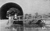
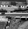
Some brilliant pictures coming up in this thread. I especially like the one of Stratford Road bridge in #27 from Phil. This must have been taken from the north side of the weir and is just as I remember it when the river was not in flood, with shingle banks that us kids called "islands".

I'm not sure how many of these bridges had official opening ceremonies which give us a bit more information and enable us to put dates to them, but I'm slowly searching through the newspaper archives and live in hope!

Maurice
 
!!!!!!!!!!!!!!!!!!!!!!!!!!!!!!!!!!!!!!!!!!!!!!!!!!!!!!!!!!!!!!!!!!!!!!!!!!!!!!!!!!!!!!!!!!!!!!!!.jpgSorry Jim it's me confusing myself it's the other end of Fast Pitts Road by Millhouse Road was called Wash Mill , Hob Moor Road and Hob Moor Lane were different Roads in 1880 here's an 1880 map Hob Moor Lane started at the Yew Tree just before Yardley House is marked on the map and something I didn't know till recently Holder Road becomes Wash Lane at it's junction with Fast Pitts Road , I always thought it began at Hob Moor Road
 
The Aquaduct at Peterbrook Road, lived 1/2 mile away for 25 years .
My avitar is me going through there on one occassion when flooded.

Colin
 

Attachments

  • Peterbrook Road.jpg
    Peterbrook Road.jpg
    53.7 KB · Views: 42
Thanks Colin. I've searched in vain for details of the opening of the Formans Road bridge too, but the only thing I can come up with is a statement that the contract was completed in 1914. There doesn't seem to have been any sort of official opening ceremony.

Maurice
 
Another photo of The New Bridge, Stratford Rd, Sparkhill. Which looks to be pretty much soon after it was built.
You are correct. In a book I have on "Images of Hall Green" compiled by Michael Byrne, a postcard of this picture was posted on 18 October 1914. Dave
 
The wooden footbridge at Green Lane (later Green Road), Hall Green, was on the south side of the road. The metal and concrete bridge that replaced it was on the north side. I can only ever remember the bridge being on the north side (Late 1940s onwards). Phil has posted a photograph (#16) of the wooden bridge and in a book I have it says that it was taken in approximately 1930. Dave.
 
1940s for me too, Dave. And it was certainly a wooden bridge on the same side as the current steel bridge. On the other side were just two concrete posts with a chain between them. The Cole certainly used to carry a lot more water than it does today caused by many brooks draining into it. Those brooks have now disappeared due to first wells and later drainage being installed.

Maurice
 
In the 1040's. at Golden Hillock Road School, we had no playing field, so we played all our "Home" games of cricket and football at Cole Bank Road Playing Field, and I seem to remember the River Cole ran somewhere along the side of the playing field. Eddie.
 
I live in Bacons End and we have 2 bridges over the Cole to each side of our estate.

Bacons End bridge, Chester Road, this is a formerly medieval bridge remodelled in 1700s and again in 1925, and also the Coleshill hall bridge on the
Birmingham road between Bacons End and Coleshill, the river then flows to Coleshill under the narrow bridge at the bottom of the High street.

Incidently, the Cole joins the Blythe in Coleshill close to Hams hall, this flows into the Tame, which flows into the Trent which flows to the Humber and the north sea, long way for the Pooh sticks to go,LOL.
 
Alberta:

Again no official opening for Bacon's End bridge and all I can find around 1925 are AA reports that the bridge is under reconstruction.

Maurice
 
Maurice there have been tests in the past that date the stonework and there are historical documents of the bridge being used in 1764 as part of Bacons Farm.
The name Bacons End dates back to the 1400s when the land was owned by a John Bacon,in later years people believed it was called after a pig farm butnalthough I believe there was one here about 60 years ago it didn't give the area its name. Alberta
 
Thanks for the info, Alberta. I'm not familiar with that area at all, never having had occasion to go there. Although born in Aston, I am essentially a South Brummie boy!

Maurice
 
Re Bacons End Bridge, I have two photos, one showing the bridge in the distance circa 1920's, and the other, I have'nt a clue to be honest, it does'nt look at all familiar to me even though it says Bacons End and I only live just up the road from there. I have never heard of a Johnny Warners bridge.
 

Attachments

  • Bacons End bridge.jpg
    Bacons End bridge.jpg
    29.5 KB · Views: 50
  • bacons end bridge c1920s.jpg
    bacons end bridge c1920s.jpg
    40.7 KB · Views: 51
Hi,

So which bridge is this, - the second picture says Chester Road Bacons End,
so is this the bridge on the Stonebridge Road, or the one in Cooks Lane?

Kind regards

Dave
 
JohnnyWarners bridge is the one over the Chester road just past the traffic island by the Labour club.
In his history of Bacons End,Bill Dargue says that it was called johnny warner bridge around the time it was remodelled in 1925.
No explanation why but perhaps it was the farmer who owned the land at the time.
 
Last edited:
Thanks for the explanation Alberta, but I am still no wiser, I just can't visualise it at all. Which way are we looking, towards Stonebridge or towards Castle Bromwich? As for Johnny Warner, I have never heard of him and I have lived around this area for the last 60 years.
 
A very poor photo of what looks to be the bridge over the Cole at Warwick Rd Greet, in this photo it looks half built. Another photo shows the bridge some good few years later from the other direction.
 

Attachments

  • Greet Warwick Rd (3).jpg
    Greet Warwick Rd (3).jpg
    67.2 KB · Views: 42
  • Greet Warwick Rd.jpg
    Greet Warwick Rd.jpg
    38.8 KB · Views: 41
Hi Phil,

Should be able to confirm the first one from the company name on the roof, but I just can't visualise the second one, though it is quite blurred, but good to have them anyway.

Maurice
 
Maurice

The first photo is cropped from a larger photo, and the building with the name on the roof was later to become Brook Tool Ltd. It's actually the place where I had my first job at 15. I think I lasted about 3 months before I quit, I was never keen on working for slave labour rates. The blurred photo is correct also as the buildings on the left by the tree are the shops on Warwick Rd at the bottom of Weston Lane.
 
Neither can I Terry, the road over the bridge would have to have been levelled and whichever way you look the land goes uphill today and the field in the distance is at a higher level.
As for JohnnyWarner, I had never heard of him or the bridge being called that in my 50 years in the area until I read the history of Bacons End.
 
Last edited:
Hi Alberta,

Many thanks for the info, I thought it must have been that one.

Do you remember the remains of the farm that used to be between the garage at Bacon's End
and down a bit toward the Labour Club. I wonder if that was Warner's Farm.

Kind regards

Dave
 
Hi Phil,

Should be able to confirm the first one from the company name on the roof, but I just can't visualise the second one, though it is quite blurred, but good to have them anyway.

Maurice
Acocks Green History Soc. web site well worth checking out. Quite a bit of info with regard to fords and mills on the Cole
 
Wooden bridge over the Cole at Shirley, drawn in the nineteenth century by Samuel Rostill Lines
From wikipedia
 

Attachments

  • 1280px-Lines_family_sketchbook_-_River_cole.jpg
    1280px-Lines_family_sketchbook_-_River_cole.jpg
    226.2 KB · Views: 32
Hi Alberta,

Many thanks for the info, I thought it must have been that one.

Do you remember the remains of the farm that used to be between the garage at Bacon's End
and down a bit toward the Labour Club. I wonder if that was Warner's Farm.

Kind regards

Dave

Dave I have posted this before, but it probably got lost, sorry for going off topic.

Well blow me, I have just noticed Warners Bridge mentioned on this pic, and I have had it for some years, (wake up)
 

Attachments

  • bacons end farm.jpg
    bacons end farm.jpg
    960.8 KB · Views: 48
Last edited:
Hi Terry,

That's probably the farm I'm thinking of. Can't say that I recognise any of it, but I do
remember some very delapidated farm buildings there, - must be over 40 years ago,
and speaking to an old guy who lived there.

That pushes the name back a few years then!

Kind regards

Dave
 
Dave,I live in the cluster of houses between the garage on Bacons end Island and the labour club, ironically all roads named after bridges Clopton,Newby,Tyne,Tay and Runcorn.

My house was built in 1969,46 years ago,,,I lived further up the road at that time but I don't remember what was here before the houses were built
 
Back
Top