• Welcome to this forum . We are a worldwide group with a common interest in Birmingham and its history. While here, please follow a few simple rules. We ask that you respect other members, thank those who have helped you and please keep your contributions on-topic with the thread.

    We do hope you enjoy your visit. BHF Admin Team

Aston Parkland, Moors and Land

Vivienne14

Kentish Brummie Moderator
Staff member
Aston Hall (built 1618-1635) once stood in 327 acres of land. As many owners of manors and halls, the land surrounding their houses provided them with opportunities for pastimes such as hunting sports. A small portion was usually cultivated and planted as formal and vegetable gardens around the house. Eventually, in the majority of cases, land would be sold for development of housing and industry.

In the case of Aston Hall it’s land contained forests, woods, moors and farmland. (Doubtless the parliamentary damaged wood staircase in the Hall was made from local wood).

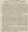
This advert of 1855 refers to the removal of Aston Park trees and underwood/fallage to make way for road building. One wooded area known as “Barton’s Wood” was to have 300 trees removed. Must have been a significant wooded area. Some of Barton Wood was close to the Walsall turnpike road.
8A80599D-1F98-488E-A9AC-7D142E04A009.jpeg
In 1853 there was also a plot/road named Barton’s Bank.

6CD1A02E-7D7F-4A9E-B1BE-D50A312028ED.jpeg

Barton features clearly in the land references, so what do we know about Barton and the connection to Aston Hall ? The Midlands Pubs site gives us clues:

Source of extract below:

F7837131-ED1E-4958-925C-1003ACEF22D9.jpeg


Do Barton’s Wood and/or Barton’s Bank (before it became a road) show up on any early maps please ? If the memory of the elderly Victorian person in the Midlands Pubs extract is correct, part of Barton’s Wood could have been where the Barton’s Arms stands today. Are the Aston Hall ‘Moors’ marked anywhere ? And does ‘Keepers Clump’ appear anywhere ?
Viv.
 
Last edited:
After some rummaging I’ve now found Barton’s Wood (red dot) marked on an 1830s map. It was to the west of Aston Hall (near Lozells Lane on the map). I think Barton’s Wood possibly reached as far as today’s A42 (Birchfield Road, Aston High Street/Newtown). This just illustrates how enormous the parkland was in past times. Can we place the Barton’s Arms on this old map (its not marked) ? Would it have been south of my red dot where the roads fork (my yellow dot, right at the edge of Barton’s Wood ?

Viv.


58CE92F4-4E3E-443A-92F5-1D348F2E434E.jpeg
 
Post 2, Yellow dot would be close to the High Street and Park Lane junction, if you follow the road down to the next junction that is where the Barton Arms would be built, I can also make out Barton Street and Potters Lane.
 
On Lyn’s map, I think the Barton’s Wood area - near Lozells Lane c1758 - looks like it was called Barton’s Chase. If it was, a ‘chase’ this would have been by definition an unenclosed area of land where wild animals were preserved to be hunted. I wondered what animals would have been kept in woodland like Barton’s Wood and with a specific purpose on the Aston Hall estate ? Wild boar perhaps ?

The other map reference is Keepers Oak - was this the former name for Keepers Clump ? The use of the word ‘clump’ suggests to me an area that had been cleared of trees perhaps. This might have been the forerunner to creating the Aston Grounds site. Viv.
 
Potter’s Farm next to the Park wall marked on Lyn's map was held in/went by the name of Potter for a considerable time. By 1855 it was being referred to as Potter’s ‘Old Farm’. In 1866 the Birmingham Steam Laundry had taken over and built on a portion of land near the old farm (referring in the article to the old farm building as Potter’s Farm and the ‘manor farm-house’).

The later road of Potters Lane must have taken its name from this old farm.

I wonder if these buildings on the 1830s map (below my red dot) are where the farm buildings once stood ? It would have been a substantial farm if described as the ‘manor farm-house’. If looks likely it was relatively close to the Barton’s Arms pub site and the farm would have been there when the first pub existed. (And of course as a reminder we have Potter’s Lane which runs alongside the pub today).

Can we pinpoint the Birmingham Steam Laundry on a map after 1866 (if there is a map) ? Viv
9148783F-F5A1-4B5E-BDB0-4D6E1A8BA3C6.jpeg
Source of all newspaper extracts: British Newspaper Archive
 

Attachments

  • 0B50E2C6-1E93-4177-BC4F-08844702B8A6.jpeg
    0B50E2C6-1E93-4177-BC4F-08844702B8A6.jpeg
    327.9 KB · Views: 9
  • B773076D-D9CE-44CB-8E39-3A4F74668079.jpeg
    B773076D-D9CE-44CB-8E39-3A4F74668079.jpeg
    97.8 KB · Views: 7
  • D49749F5-EF89-428D-8FC4-03BBF5D9C0A0.jpeg
    D49749F5-EF89-428D-8FC4-03BBF5D9C0A0.jpeg
    149.2 KB · Views: 7
  • 2B4B354C-C5BA-4779-85A5-E01A1F940F11.jpeg
    2B4B354C-C5BA-4779-85A5-E01A1F940F11.jpeg
    135.3 KB · Views: 8
Last edited:
think your red dot is about right viv...i believe the original bartons arms pub was on the same spot give or take..i have this 1758 map that maybe of interest on this thread

View attachment 176983
I notice on the map that there's a river and a mill by the name of Bourn, I only know the Bourne Brook over the other side of Birmingham - therefore would that have later been known as the Hockley Brook?
 
Here is the tithe map of 1845. all the land with the purple dots was occupied by Richard Potter, though owned by
Jeffery Berrington Lowe & Kelynge Greenway & Mary Greaves & Richard Greaves. The area of the green indicator was owned by Catharine Chatterway , and occupied by Charles Twiss.

TITHE MAP OF 1845 AROUND BARTON ARMS SITE.jpg
 
Last edited:
I notice on the map that there's a river and a mill by the name of Bourn, I only know the Bourne Brook over the other side of Birmingham - therefore would that have later been known as the Hockley Brook?
This may explain - from Bill Dargue’s origins of street names:

Aston Brook, also known as Hockley Brook and, nearer its source as The Bourn or River Bourn, runs from Hockley east-west to join the Rea and Tame; it was culverted from the 19th century and is only visible in one or two places including its confluence near Spaghetti Junction. Aston Brook Mill was a fulling mill from at least 1532 until the late 18th century when it became a corn mill operating until c1914. The millpool was in the Pool Street/ Phillips Street area. Lane B6
 
Last edited:
According to Alan Godfrey (Maps), when the Hall was acquired by Whitehead & Greenway (Warwick bankers) it was subsequently rented to James Watt Jnr in 1819, Watt didn’t rent the entire 329 acres of the parkland: Watt rented 136 acres and, 123 acres plus the Home Farm were let to Samuel Potter, a farmer. Richard Potter who was renting the plots marked on Mike’s tithe map (1845) in post #9 must have been a relation of Samuel Potter.

Viv
 
Last edited:
I was just wondering if Potters Hill in Aston was connected to the family and, yes, it was!
 
Back
Top