-
Welcome to this forum . We are a worldwide group with a common interest in Birmingham and its history. While here, please follow a few simple rules. We ask that you respect other members, thank those who have helped you and please keep your contributions on-topic with the thread.
We do hope you enjoy your visit. BHF Admin Team
You are using an out of date browser. It may not display this or other websites correctly.
You should upgrade or use an alternative browser.
You should upgrade or use an alternative browser.
Newhall Street
- Thread starter Dave M
- Start date
S
Stitcher
Guest
Pedrocut
Master Barmmie
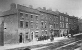
Assuming that the lowest point of Newhall Street is at the crossroads with Charlotte Street, which way are we looking?
Pedrocut
Master Barmmie
Yes I think that’s right. Looking again there are two two dips in Newhall Street. This one looking down to Cornwall Street.
https://earth.app.goo.gl/epQ9
https://earth.app.goo.gl/epQ9
A Sparks
master brummie
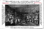
Interesting!This was the Colmore Sale Rooms and Auction Mart at #3 Newhall Street, Viv
View attachment 176069Source: British Newspaper Archive
I see the owner lived in Birchfield, the Victorian houses in that road are still there.
Thanks ASparks I’ve just had a look. Most of the road seems to be terraced villas with name plaques still on the buildings. I suspect Holly Bank would have been where Salisbury Road joined Birchfield Road. I think at some point Birchfield Road was widened and consequently several houses were probably removed in Salisbury Road. Perhaps it was one of those. With a name like Holly Bank it sounds to me like a detached house too. All guesswork though. Viv.
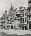
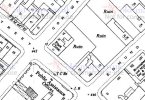
This photo was on a site trying to identify unknown photos. It was identified as 35-37 Newhall St, architects Newton and Cheatle, and constructed with materials from Gibbs and Canning terracotta manufacturers . It was destroyed by bombing during the war I am not certain whether it also includes at least another building next to 35-37, but this is arguable and not clear. 1950s map below after bombing


