-
Welcome to this forum . We are a worldwide group with a common interest in Birmingham and its history. While here, please follow a few simple rules. We ask that you respect other members, thank those who have helped you and please keep your contributions on-topic with the thread.
We do hope you enjoy your visit. BHF Admin Team
You are using an out of date browser. It may not display this or other websites correctly.
You should upgrade or use an alternative browser.
You should upgrade or use an alternative browser.
Where is it, Birmingham #9
- Thread starter Pedrocut
- Start date

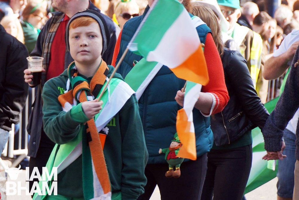
Power cut ! Ha ha. No image! Viv.
Something Irish ? Viv.
They’re carrying hurling sticks. Viv.
Late 60s, and probably in the City Centre. But what is the occasion ?View attachment 148792
looking at the mens coats pedro maybe late 50s they look like hurling sticks to me..ladies are wearing green sashes
Could be a St. Patrick's Parade, but where in the city centre ?
And what team?
yes it could be pedro...looking at the buildings for clues
Is the Parade usually Digbeth ? Doesn’t look like Digbeth though. Looks more like Broad Street to me. But there again ..... Viv.
Is the Parade usually Digbeth ? Doesn’t look like Digbeth though. Looks more like Broad Street to me. But there again ..... Viv.
this one is difficult viv but great as it gives us something to do
Pedrocut
Master Barmmie
Just looking at this year's cancelation of the Parade, it says that it started in 1952. Maybe this was from the early days ?
 www.iambirmingham.co.uk
.
www.iambirmingham.co.uk
.
Coronavirus: St. Patrick's Day parade cancelled in Birmingham | I Am Birmingham
Organisers have confirmed this Sunday's St. Patrick's Day parade in Birmingham has been cancelled amid coronavirus concerns. The Birmingham St. Patrick's D
www.iambirmingham.co.uk
Can anyone identify the hurling team’s kit ? Viv.

Radiorails
master brummie
The colours suggest Wexford.
Rather a lot of them. From 1962 Kellys;
Civic Radio Services Ltd. radio & television dlrs. (office),
7/8 Easy row 1 (Midland 31211); 12/14 High st 8
(East 1620); 796 Stratford rd n (Springfield 2028);
288 Stratford rd. Sparkbrook 11 (Victoria 3942); 2272
Coventry xd1 26 {Sheldon 4819); 213 New John street
west 19 (Northern 4671); 53 'Lozells rd 19 (Northern
0252); 126 High st 23, (Brdington 0112); 2 Livery st 3
(Central 2540); 6 Albert st 4 (Midand 6801); 59
Warwick rd. Olton (Acocks Green 2642); 803 Warwick
rd 11 (Acocks Green 1118); 267 Coventry rd 10 (Victoria
4474); 867 Bristol road south 31 ^(Priory 5363);
service dept. Records & accessories, 1 Easy row 1 (Midland
546.7) & 156 High st 17 (Harborne 4234) & 38 Cape
hill 41. Smethwick 2767
St Patrick’s day parade sashes are often green with a yellow flash or stripe. Is the band Clive Fox Band ? Viv.

Radiorails
master brummie
I thought Slieve Fox. (Mountain Fox I think.)
That building behind the pipers is a well known place, featured in posts on BHF I believe.
That building behind the pipers is a well known place, featured in posts on BHF I believe.

pjmburns
master brummie
Wexford were champions in 1955, 1956, 1960 and 1968. So might have either come for the parade or been represented.The colours suggest Wexford.
Pedrocut
Master Barmmie
Some of the pictures he took were quite remarkable for someone who had been right handed. He didn’t use a tripod, but would find things on which to lean to steady the arm.
Here is one he took of the Rotunda under constructio.

 www.ipernity.com
Here is one he took of the Rotunda under constructio.
The building of the Rotunda (around 1964) - Old Birmingham
By Pedrocut. A scan of a slide taken by my late uncle. The Rotunda was completed in 1965.
www.ipernity.com
Pedrocut
Master Barmmie
Here are a few from Devon in the 60s. (Click to enlarge). The slides are dirty and take a bit of cleaning up, but the quality you seem to get from old slides are sometimes amazing...

sospiri
GONE BUT NOT FORGOTTEN
Pedro,
Yes, I remember the Golden Hind replica from the early 60s, but I gather that there has been at least one more since then.
Memories of a somewhat disastrous holiday with my late brother-in-law and his wife, Their tastes were the exact opposite of my wife and I and in my experience those sort of family holidays later in life rarely work out.
Maurice
Radiorails
master brummie
No it is the same Golden Hind, built upwards from a barge (Thames I believe). It has had a couple of fires, which I attended and has been superficially changed over the years. It has only moved one - it went down the coast to Dartmouth where it sank alongside the river wall. Just the masts showing above the water line.
However there is another sea worthy Golden Hinde (note the 'e') which is at Southwark, London.
I think that ship was the one I saw one day - quote by chance - sail to the entrance of the inner harbour at Brixham, where the replica vessel lies, and fired a cannon then set sail back into Torbay (area of water named long before the place name).
I guess the cannon shot was a one-upmanship statement by the Golden Hinde which, I gather is a faithful replica and seaworthy. There have been many changes since the 1960's in Brixham, bit most places in the photos are quite recogniseable.
pjmburns
master brummie
At the moment the only "Civic" I can find on a corner is on the corner of Edmund Street and Easy Row. It is in the 1960 phone book and on the 1955 map but had gone by mid 1960s. Problem is I can't remember the area well enough to know. Could the "older" building be the building marked on the map as University of Birmingham? So photo taken looking down Edmund Street as the parade turned onto Easy Row?
Just a suggestion.

Just a suggestion.